Etymology
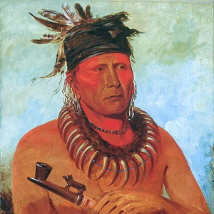
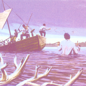
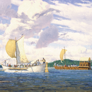
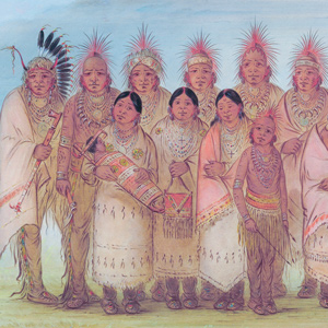
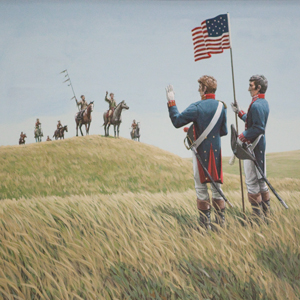
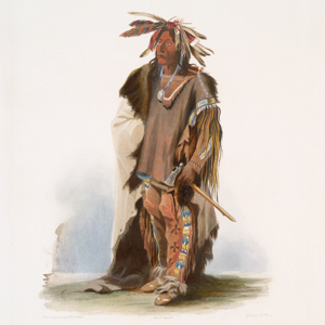
Addressing the Otos and Missouris at Council Bluffs
32″ x 36″ oil on canvas
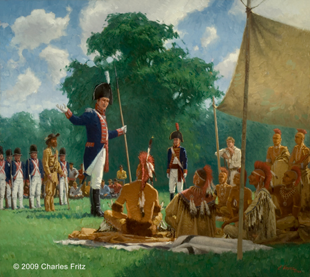
© 2009 by Charles Fritz. Used by permission.
Jesuit missionary Jacques Gravier (1651–1708), considered to be a qualified linguist, recorded in his 1700 Dictionary of the [Algonquian] Illinois Language, that the name Missouria was derived from the Illinois word meaning ‘dugout canoe‘ which soon became to French speakers Missouria, ‘people having dugout canoes‘. A more recent interpretation refines the meaning as ‘big boat’.[1]Douglas R. Parks, Handbook of North American Indians: Plains Vol. 13, ed. Raymond J. DeMallie (Washington, D.C.: Smithsonian Institution, 2001), 461. See also The Jesuit Relations and Allied … Continue reading
War-doke-tar-tar is the captains’ spelling of the Otoe’s name for themselves. The name is often associated with watúhtana, ‘to copulate’, a meaning reinforced in popular stories. That etymology is somewhat alluring, but it has no historical basis other than folk tales. In reality, the origin of the people’s name is obscure.[2]Parks, 460.
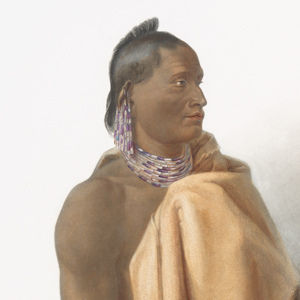
At the time of the expedition, the nation from which the Missouri River derived its name were so reduced by smallpox and attacks from primarily the Sauks and Foxes, that they had abandoned their villages and merged with other tribes—Kansas, Osages, but primarily, the Otoes. After the merge began in the mid-1790s, the Missouria maintained their distinct identity by practicing their own clan system and customs. Today the two tribes are formally recognized as the Otoe–Missouria Tribe.
Bourgmont’s Paris Delegation
In 1725, French explorer Étienne de Veniard, Sieur de Bourgmont (1679–1734) escorted a delegation to Paris which included two Missouria chiefs, one Otoe chief, and Bourgmont’s Missouria wife. Perhaps to avoid scandal or jealousy from his French wife, Jacqueline Bouvet des Bordeaux, he had his Missouria wife baptized and then married to his co-worker, one Sergeant Dubois. In the five years prior, Bourgmont was commissioned a captain, appointed “Commander of the Missouri River,” and charged with building Fort Orleans at the mouth of the Grand River near the Missouria village Utz.[3]“Étienne de Veniard, Sieur de Bourgmont,” Wikipedia, https://en.wikipedia.org/wiki/%C3%89tienne_de_Veniard,_Sieur_de_Bourgmont, accessed 17 January 2021. The expedition noted the abandoned village as they passed on 13 June 1804. Two days later, they passed another abandoned Missouria village known today as Gumbo Point.[4]Marjorie M. Schweitzer, Handbook of North American Indians: Plains Vol. 13, 447–48.
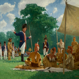
First Council
The Lewis and Clark Expedition’s first council was with the Otoes and Missourias. Elaborate preparations preceded. In Philadelphia, Lewis started buying Indian presents. He also brought commissions, sometimes called paroles, presentation flags, and government–issued peace medals. In St. Louis, more Indian gifts were purchased, and in late April 1804, Cahokia–based merchant and fur trader John Hay helped organize and pack the diplomatic presents likely into bundles designated for specific nations. The speech was likely written previously.
The Otoe finally arrived at the expedition’s camp near present-day Fort Calhoun, Nebraska, as the sun set on 2 August 1804. The next day, the council commenced. The people were informed of the change in government and asked to abandon their allegiance and trade relationships with the Spanish and English. Chiefs were designated, given American medals and commissions, and the people were asked to be at peace with other tribes. Technological power, such as Lewis’s air gun, were demonstrated. The formula was repeated many times as the expedition traveled through the Upper Louisiana Territory.
Tradition vs Assimilation
After several treaties, land cessions, and reservations, the Otoe-Missouria split into two factions: those seeking to maintain traditional life ways and those seeking to assimilate with white society. The assimilationists had aligned with Quaker missionaries and as such were called the Quaker Band. The traditionalists were called the Coyote Band—not to be confused with the Coyote clan. The two bands would eventually rejoin as one people only to see their reservation divided into individual allotments as authorized by the Dawes Severalty Act of 1887 with later amendments. The Burke Act of 1906 authorized the Department of Interior to issue fee simple patents encourating Native American allotment owners to sell to whites. Just four years later, 78 of the 514 Otoe-Missouria allotments had been sold—15 percent.[5]Schweitzer, 457; “Dawes Act,” Wikipedia, https://en.wikipedia.org/wiki/Dawes_Act, accessed 17 January 2021.
Today, the Otoe-Missouria Nation is headquartered in Red Rock, Oklahoma with tribal jurisdiction in parts of Noble and Kay County. The tribe maintains seven secretive clans and traditional ceremonies and beliefs such as the sacred circle found in the dance ground and drum, praying to Wakanda and the four directions, and the funeral ritual and feast. They are also systematically reviving their language.[6]Otoe–Missouria Tribe of Indians, Wikipedia, https://en.wikipedia.org/wiki/Otoe%E2%80%93Missouria_Tribe_of_Indians, accessed 17 January 2021; Schweitzer, 458; “Otoe–Missouria Tribe,” … Continue reading
Selected Pages and Encounters
Too Né’s Delegation
by Joseph A. Mussulman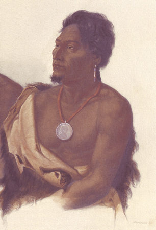
A delegation of chiefs from the Arikara, Ponca, Omaha, Otoe, Iowa, and Missouria nations sailed down the Missouri with Corporal Warfington on the expedition’s keelboat in the spring of 1805. Early in January, 1806, President Jefferson greeted them in Washington City with a formal speech.
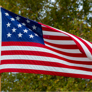
Flag Presentations
by Joseph A. Mussulman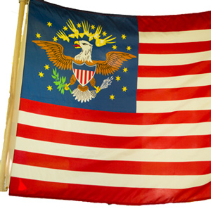
Lewis and Clark usually distributed flags at councils with the chiefs and headmen of the tribes they encountered—one flag for each tribe or independent band.
April 22, 1804
Our Missouria Indian
In St. Louis, the captains work with Pierre Chouteau‘s recently arrived delegation of Osage Indians. An undated note says that the captains have decided not to bring aboard a Missouria man who has been staying at Camp River Dubois.
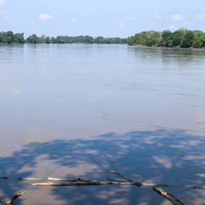
June 13, 1804
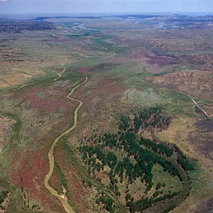
The mouth of the Grand
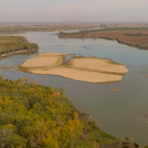
The enlisted men and engagés move the boats nine miles up the Missouri passing sandbars, shoals, and an abandoned Missouria village. They camp at the mouth of the Grand River where Clark and Lewis climb a hill for the view and make lunar observations late into the night.
June 15, 1804
Malta Bend hazards
All day, the enlisted men and engagés struggle to move the boats around the Missouri River hazards. Submerged logs and crumbling banks add to the danger. They make 12¼ miles camping near abandoned Osage and Missouria villages at present Malta Bend.
July 5, 1804
Seaman's chase
Heading up the Missouri, the current turns the boats around three times, and Lewis’s dog, Seaman, drives some beavers from their house. They pass an old fort and Missouria village before encamping near the present Bluffwoods Conservation Area in Missouri.
July 11, 1804
Entering Nebraska
In present Nebraska, the enlisted men and engagés move the boats just six miles before camping on an island at the mouth of the Big Nemaha River. Sgt. Floyd says they will rest a day or two because “the men is all Sick”.
Elsewhere, an Osage delegation organized in part by the captains arrives in Washington City.
July 14, 1804
A sudden storm
Below present Langdon, Missouri, the expedition encounters a sudden storm, and the enlisted men and engagés must jump into the water to save the boats. When an elk is wounded, Lewis’s dog, Seaman, joins the chase. Before stopping for the day, they pass an old Otoe and Pawnee trading post.
July 20, 1804
Prairie clovers
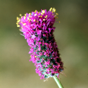
Moving along the present Nebraska-Iowa border, the expedition passes Water-which-Cries and Waubonsie creeks. Lead hunter George Drouillard is sick, so Sgt. Pryor and Pvt. Joseph Field hunt on shore this day. Lewis collects specimens of purple prairie clover and white prairie clover—both lost, and Clark describes the boils affecting several of the enlisted men.
July 21, 1804
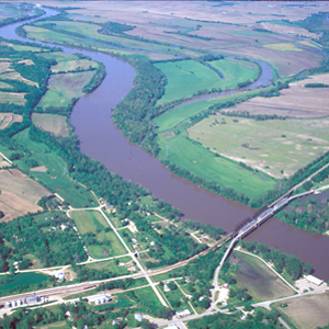
Passing the Platte
At midday, the expedition arrives at the mouth of the Platte where they remark on the sandy river’s effect on the Missouri. Before continuing, the captains take a pirogue one mile up the Platte and confirm that the river cannot be navigated with boats or canoes.
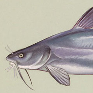
July 22, 1804
White Catfish Camp
Near present Bellevue, Nebraska, the expedition sets up a camp that Lewis would later call White Catfish Camp. The captains find a shady place near to rest and arrange a council with the Otoes, and Lewis describes his astronomical instruments.
Omaha-Council Bluffs
Nobody home
by Joseph A. Mussulman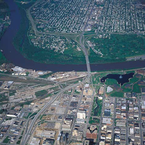
On 23 July 1804, the captains sent Drouillard and Cruzatte to an Otoe Indian village to invite the chiefs to come hear of the change of national allegiance from Spain to the United States and to learn “the wishes of our Government to Cultivate friendship with them.”
July 23, 1804
In search of Otoes
At White Catfish Camp near present Bellevue, Nebraska, an American flag is hoisted as a signal for the Otoes to visit. George Drouillard and Pvt. Cruzatte are in sent in search of them with an invitation to council. At camp, everyone is engaged with various tasks.
July 25, 1804
Empty Otoe village
Near present Bellevue, Nebraska, George Drouillard and Pierre Cruzatte return to White Catfish Camp without finding any Otoes or Pawnees. Finding the Otoe village empty, they had continued their search as far as the Elkhorn River.
July 27, 1804
Leaving White Catfish Camp
At White Catfish Camp, the enlisted men and engagés load the boats, and they proceed to present Lewis and Clark Landing in Omaha, Nebraska. Clark investigates mounds and an old Otoe village and returns after dark. A knee is cut, mosquitoes rage, and Lewis adds several plant specimens to his collection—now lost.
July 28, 1804
Old Iowa village
The expedition leaves present Omaha, Nebraska and passes an old Iowa village on the opposite side of the river. While out hunting, Drouillard meets a Missouria man who lives with the Otoes, and he brings the man to the evening’s camp west of Crescent, Iowa. The visitor tells the captains that most of the Otoes are away hunting buffalo.
August 1, 1804
A botanist's field day
At present Fort Atkinson, Nebraska, Clark prepares a peace pipe anticipating that the Otoes will soon arrive for a council. Two men search for lost horses and others search for the Otoes.
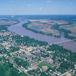
August 3, 1804
The Otoe council
Most of the day is spent exchanging speeches, gifts, and knowledge with the Otoes and Missourias on Council Bluff at present Fort Atkinson, Nebraska. Then, the boats travel six miles up the Missouri.
August 17, 1804
Otoe chiefs and a deserter
At Fish Camp near present Homer, Nebraska Pvt. Labiche informs the captains that three Otoe chiefs and the deserter Pvt. Reed will soon arrive. A prairie fire is set as a signal to any nearby Indians.
August 18, 1804
Trial and punishment
At Fish Camp near present Homer, Nebraska, Drouillard’s party returns with deserter Pvt. Reed and some Otoes. At the ensuing trial, Reed is found guilty and sentenced to run a gauntlet four times. The Otoes witnessing the punishment ask for mercy. To celebrate Lewis’s birthday, the enlisted men are given an extra gill of whiskey.
August 19, 1804
Otoe's council, Floyd's illness
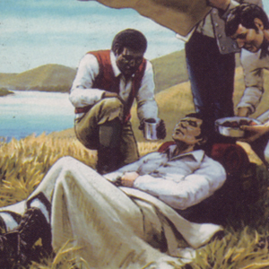
During a council at Fish Camp near present Homer, Nebraska, speeches with the Otoes are exchanged, but they appear dissatisfied with their gifts. Sgt. Floyd becomes seriously ill requiring urgent care.
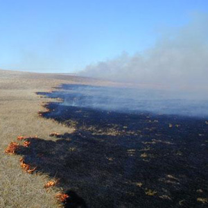
August 24, 1804
Bluffs on fire
On their way to the Vermillion River, the expedition passes a burning bluff that some call the Ionia Volcano. They express curiosity about a small mound—present Spirit Mound—that the Indians fear.
Spirit Mound
An elevation of devilish spirits
by Joseph A. Mussulman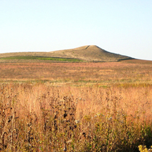
The visit to this prairie hill was among the more bizarre sidelights of the whole expedition, but evidently it was not entirely unexpected. Seventy-six years earlier, explorer Pierre La Véndrye called the place the “Dwelling of the Spirits.”
August 31, 1804
Yankton speeches
The council with the Yankton Sioux continues with many of them giving speeches while Clark and Sgt. Ordway take notes. Trader Pierre Dorion is assigned a mission to make peace with the region’s Nations.
May 20, 1805
"Sâh-câ-gar me-âh or bird woman's River"
The captains name a creek Blowing Fly after the blowflies that often congregate on raw meat and open wounds. At the mouth of the Musselshell, they explore and take celestial observations. A tributary of the Musselshell is named “Sâh-câ-gar me-âh [Sacagawea] or bird woman’s River”.
Elsewhere, the barge, that headed down the Missouri from Fort Mandan on 7 April 1805, arrives in St. Louis.
October 8, 1805
A canoe accident
On the Clearwater River, the paddlers navigate numerous rapids and pick up guides Twisted Hair and Tetoharsky. After a canoe accident at Colter’s Creek—present Potlatch River—travel abruptly stops.
January 4, 1806
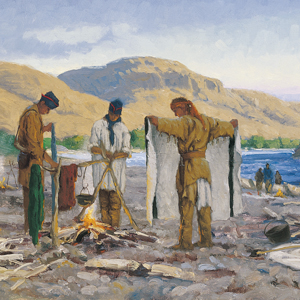
Across the Clatsop Plain
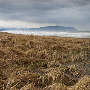
Sgt. Gass and Pvt. Shannon travel through the marshes and dunes of the Clatsop Plain on their way to the salt makers’ camp. At Fort Clatsop, Lewis describes Clatsop views on material goods.
September 16, 1806
A young trader
Moving down the Missouri, they question a young trader—likely Joseph Robidoux Jr.—who lacks a properly signed license. They end the day near present Waverly, Missouri 52 miles closer to home.
September 20, 1806
La Charrette welcome
After 68 miles of hard paddling, the expedition arrives at the French settlement of La Charrette. They fire three rounds, and the villagers return the welcome. They enjoy their first beef since leaving.
Notes
| ↑1 | Douglas R. Parks, Handbook of North American Indians: Plains Vol. 13, ed. Raymond J. DeMallie (Washington, D.C.: Smithsonian Institution, 2001), 461. See also The Jesuit Relations and Allied Documents: Travels and Explorations of the Jesuit Missionaries in New France, 1610–1791, Reuben Gold Thwaites, ed. (Cleveland: Burrows Brothers Company, 1899), 263; Jacques Gravier, Dictionary of the [Algonquian] Illinois Language, held by the Watkinson Library, Hartford, Illinois, also available at archive.org; Michael McCafferty, “On the birthday and etymology of the placename Missouri,” Names, 51:31–45 in William Bright, Native American Placenames of the United States (Norman: University of Oklahoma Press, 2004), 290. |
|---|---|
| ↑2 | Parks, 460. |
| ↑3 | “Étienne de Veniard, Sieur de Bourgmont,” Wikipedia, https://en.wikipedia.org/wiki/%C3%89tienne_de_Veniard,_Sieur_de_Bourgmont, accessed 17 January 2021. |
| ↑4 | Marjorie M. Schweitzer, Handbook of North American Indians: Plains Vol. 13, 447–48. |
| ↑5 | Schweitzer, 457; “Dawes Act,” Wikipedia, https://en.wikipedia.org/wiki/Dawes_Act, accessed 17 January 2021. |
| ↑6 | Otoe–Missouria Tribe of Indians, Wikipedia, https://en.wikipedia.org/wiki/Otoe%E2%80%93Missouria_Tribe_of_Indians, accessed 17 January 2021; Schweitzer, 458; “Otoe–Missouria Tribe,” https://www.omtribe.org, accessed on 18 January 2021. |
Experience the Lewis and Clark Trail
The Lewis and Clark Trail Experience—our sister site at lewisandclark.travel—connects the world to people and places on the Lewis and Clark Trail.
![]()
Discover More
- The Lewis and Clark Expedition: Day by Day by Gary E. Moulton (University of Nebraska Press, 2018). The story in prose, 14 May 1804–23 September 1806.
- The Lewis and Clark Journals: An American Epic of Discovery (abridged) by Gary E. Moulton (University of Nebraska Press, 2003). Selected journal excerpts, 14 May 1804–23 September 1806.
- The Lewis and Clark Journals. by Gary E. Moulton (University of Nebraska Press, 1983–2001). The complete story in 13 volumes.
This site is provided as a public service by the
![]()
Lewis and Clark Trail Alliance
with additional funding from the following:

