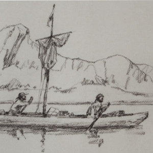
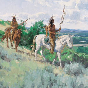
Absaroka Scouts, Elk River
10″ x 18″ oil on board
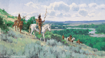
© 2009 by Charles Fritz. Used by permission.
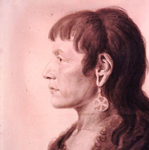
In the list of names and descriptions of North American tribes that Lewis and Clark compiled at Fort Mandan, they called the people living along the Yellowstone River, “as usially Spelt and pronounc’d” by the English—and in Clark’s idiosyncratic spelling—”Ravin nation.” Clark wrote the “primitive” name phonetically as Arp-Sar-co-gah, and gave the nickname that “generally obtained among the Canadian Traders as “Cor beaus” (i.e., corbeaux, French for “crows” or “ravens”). But the people called themselves Apsáalooke , sometimes heard as Absarokas, or “Children of the Large-beaked Bird.” Various early white travelers transcribed or defined the name differently, but the Apsáalooke maintain it refers to the raven. Naturally, the Plains Sign Language gesture for them is the flapping the arms like wings.[1]Douglas R. Parks, Handbook of North American Indians: Plains Vol. 13, ed. Raymond J. DeMallie (Washington, D.C.: Smithsonian Institution, 2001), 715.
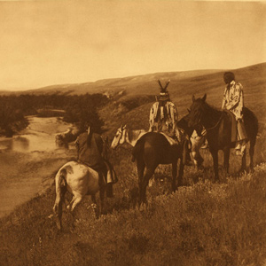
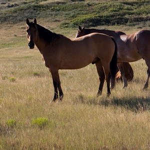
Starting in the late 1600s, perhaps earlier, the Apsáalooke began a gradual process of separation with the Hidatsas. The Mountain Apsáalooke and Awatixa Hidatsa share a common ancestry as do the River Apsáalooke with the Hidatsa proper.[2]Fred W. Voget, Handbook of North American Indians: Plains Vol. 13, 695. At the time of the expedition, the two nations maintained annual visits, and Toussaint Charbonneau and his wife, Sacagawea, would likely have known, and be known by, many Apsáalooke individuals. During the expedition, no one would see any Apsáalooke People, but those people certainly noticed the expedition passing through their lands.
While exploring the Yellowstone, the travelers did see signs of the Apsáalooke. When horses starting disappearing during the night at Yellowstone Canoe Camp, unseen Apsáalooke thieves were suspected. Clark’s speech imploring the return of his horses never found its intended audience. In a final encounter, the remaining horses were stolen from Sgt. Nathaniel Pryor‘s small group who were charged with taking them to the Knife River Villages as currency in a bold diplomatic plan.
In the “Estimate of the Eastern Indians,” Clark explains the role the Apsáalooke played in trade between the Shoshones, who traded with the Spanish, and the Knife River Villages and Hidatsas, who traded with the North West and Hudson’s Bay companies:
These people are divided into four bands, called by themselves A-hâh’-âr-ro’-pit-no-pah, Noo’-ta, Pa-rees-car, and E-hârt’-sâr. They annually visit the Mandans, Minetares [Hidatsas], and Ahwahhaways [Iowas], to whom they barter horses, mules, leather lodges, and many articles of Indian apparel, for which they receive, in return, guns, ammunition, axes, kettles, awls, and other European manufactures. When they return to their country, they are in turn visited by the Paunch and Snake Indians, to whom they barter most of the articles they have obtained from the nations on the Missouri, for horses and mules, of which those nations have a greater abundance than themselves. They also obtain from the Snake Indians, bridle-bits and blankets, and some other articles which those Indians purchase from the Spaniards. The bridle-bits and blankets I have seen in the possession of the Mandans and Minetares.[3]Moulton, Journals, 3:428.
Today, the Apsáalooke have one federally recognized tribe, the Apsáalooke Nation—or Crow Tribe—of Montana, and many of the people’s ways and language, including their horse culture, are relatively well-preserved.
Selected Pages and Encounters
Montana’s Indian Country
Changes after the expedition
by Rick Newby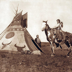
Beginning with the Fort Laramie Treaty of 1851, the U.S. government set the vast area north of the Missouri (approximately 20 million acres) aside as the “Blackfeet Hunting Ground” for the Blackfeet and other tribes—Cree, Assiniboine, Gros Ventre, and Sioux.
August 30, 1804
Yankton council and dance
At a council with the Yankton Sioux, Lewis delivers a speech, gifts given, and a peace pipe passed. Clark learns about the Akicita Society, and Sgt. Ordway finds their musical instruments interesting.
August 31, 1804
Yankton speeches
The council with the Yankton Sioux continues with many of them giving speeches while Clark and Sgt. Ordway take notes. Trader Pierre Dorion is assigned a mission to make peace with the region’s Nations.
October 12, 1804
Trading with the Arikara
At an Arikara village, the morning is spent parleying and trading. At 1 pm, the expedition heads up the Missouri River and encamps near present Shaw Creek Recreation Area in South Dakota.
November 12, 1804
Mandan history lesson
Sheheke and his wife—likely Yellow Corn—visit the Fort Mandan construction site. She brings 100 pounds of meat, and he tells the Mandan creation story. He also describes the Hidatsa and Crow Nations.
March 8, 1805
Rocky Mountain Indians
Greasy Head, a Hidatsa, and an Arikara man inform Clark about the Rocky Mountain Indians They also tell of the rescue of a kidnapped daughter.
August 13, 1805
Shoshone diplomacy
In the Lemhi River valley, Shoshone and Lewis diplomacy includes greetings, a flag presentation, a pipe ceremony, and revelry late into the night. Clark takes bearings from what is now called Clark’s Lookout.
May 11, 1806
Council at Lawyer Creek
Four major Nez Perce chiefs assemble at Lawyer Creek near Kamiah, Idaho and are added to the ongoing council. Progress is slow as the translated words must move between five different languages. The captains demonstrate the air gun and magnets and give medical aid to several applicants.
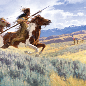
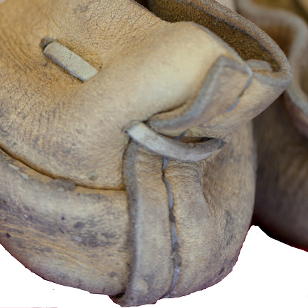
Stolen Horses
Apsáalooke horse culture
by Joseph A. Mussulman, Robert N. Bergantino
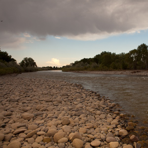
Pryor and six privates had successfully driven forty-one horses all the way to the Yellowstone Valley, apparently without any trouble. Then, smoke on the horizon. Twenty-four horses stolen on the twentieth. Seventeen taken on the twenty-fifth.
July 17, 1806
Signs of danger
The expedition is split into four detachments separated by over 200 miles. On the plains north of the Great Falls of the Missouri, Lewis and his small group see a wounded bison, a sign that Indian hunters may be near.
On the Yellowstone River, Clark and his group scout for timber to make dugouts and see an “Indian fort” used by traveling war parties. He camps near present Reed Point, Montana.
Sgt. Ordway leads the paddlers down the Missouri navigating Pine Tree Rapids and passing Tower Rock. At the White Bear Islands, Sgt. Gass and his detail wait for the arrival of Ordway and the canoes.
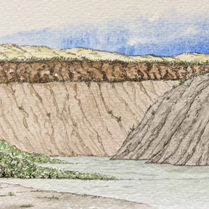
Apsáalooke (Crow) Signs
Smoke signals a discovery
by Joseph A. Mussulman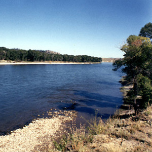
“This smoke must be raisd. by the Crow Indians in that direction as a Signal for us, or other bands. I think it most probable that they have discovered our trail.”
July 18, 1806
Smoke signals
Today, the expedition travels in five different groups separated by 200 miles. Moving down the Yellowstone River near present Columbus, Montana, Charbonneau is thrown from his horse, and Pvt. Gibson seriously wounds his thigh. They see distant smoke signals, and Clark suspects that some Apsáalooke (Crows) have discovered them.
Lewis and his small group reach the Marias River at Dugout Coulee. They see one continual herd of bison 12 miles wide, and Lewis takes turns as night guard—a rarity for a captain.
Sgt. Ordway and his paddlers nearly reach the Great Falls of the Missouri—just a day away. Meanwhile, Sgt. Gass and three men travel to the Lower Portage Camp where they take some tobacco from a cache. The rest of his men remain at the White Bear Islands.
July 19, 1806
Clark's canoe camp
Today, two detachments merge, while the other two move in different directions. Lewis and three others head up the Marias River hoping to find a northern tributary, but the creek running from Tower Mountain appears too small to extend the boundaries of the Louisiana Territory.
Moving down the Yellowstone, Clark and his group finally reach cottonwood trees large enough for making canoes. They establish a canoe camp near present Laurel, Montana and attend to Pvt. Gibson who was seriously wounded yesterday.
Sgt. Ordway and his nine paddlers reach the upper portage camp above the Great Falls of the Missouri where Sgt. Gass and his detachment have been waiting. They beach the dugouts in preparation for the portage around the falls.
July 21, 1806
Missing horses
On this day, the expedition is split into three detachments separated by 200 miles. At Clark’s Yellowstone canoe camp near present Laurel, Montana, the group wakes to find several horses are missing—likely stolen by Apsáalooke (Crows). Pvt. Gibson’s wound is healing, and one dugout canoe is nearly ready.
On the Marias River, Lewis and his small group turn up Cut Bank Creek hoping its source is above the 50th parallel. With no trees present, they make a fire from buffalo dung.
Above the Great Falls of the Missouri, Sgts. Gass and Ordway delay the portage while a search is made for missing horses. They are plagued by mosquitoes and gnats.
July 22, 1806
Lewis's great disappointment
Today, the expedition is in three groups separated by 200 miles. At Camp Disappointment on Cut Bank Creek, Lewis determines that the Marias River watershed does not go any farther north. They stop to hunt and make celestial observations.
At his Yellowstone canoe camp near present Laurel, Montana, Clark’s group searches for missing horses. They are not found, and Apsáalooke (Crow) horse thieves are suspected.
At the Great Falls of the Missouri, the portage around the falls has a bad start.
Clark’s Apsáalooke (Crow) Speech
A speech never given
by Joseph A. Mussulman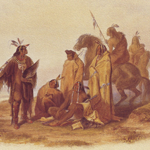
While stinging from having so many of his horses stolen, Clark wrote a speech to the Crow Indians imploring them to return the booty. After all, he needed those horses to complete the captain’s bold diplomatic plan.
July 23, 1806
Blackfeet and Apsáalooke near
The expedition travels in three groups separated by 200 miles. Due to clouds at Camp Disappointment, Lewis cannot make celestial observations. He is surprised to see Columbian ground squirrels east of the Continental Divide, and Drouillard sees signs that the Blackfeet are near.
On the Yellowstone, Clark’s group finishes two dugout canoes and begins making paddles and poles. They find signs that Apsáalooke (Crows) are trying to steal their remaining horses, and Sgt. Pryor is given his orders to take them to the Knife River Villages.
Sgts. Gass and Ordway lead the portage of the canoes around the Great Falls of the Missouri. After multiple breakdowns, they get two across Box Elder Creek and camp. Pvt. Weiser suffers a bad cut on his leg.
July 24, 1806
Pryor's mission begins
With the departure of Sgt. Pryor, the expedition is divided into four detachments. On the Yellowstone River, Clark’s new dugouts are launched. Above present Billings, they meet with Sgt. Pryor and help him take swim horses across the river. The boats continue down a rapid river making 70 miles for the day.
After crossing the Yellowstone, Pryor with three enlisted men and all the horses start out on an Indian road leading to the Knife River Villages.
At Camp Disappointment near present Cutbank, Montana, Lewis is unable to take the desired celestial observations and has a meal of pigeon, cous root, and buffalo grease.
At the Great Falls of the Missouri, Sgts. Ordway and Gass oversee the portage of the dugout canoes around the falls. One canoe is taken to the Lower Portage Camp.
Apsáalooke Country
by Joseph A. Mussulman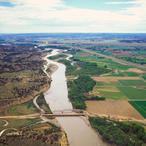
The Crow People called themselves Apsáalooke, sometimes heard as Absarokas or Absalookas, or “Children of the Large-beaked Bird.” Various early white travelers transcribed or defined the name differently, but the Apsáalooke maintain it refers to the raven. One of the oldest and most famous landmarks on Lewis and Clark’s route, now known officially, but erroneously, as Pompeys Pillar or, among the Apsáalooke, Iish-biia ah-naac’he’.
August 18, 1806
A Mandan history lesson
Despite windy conditions, the expedition makes forty miles down the Missouri River. Chief Sheheke (Big White) tells Clark his people’s history. Near the Heart River, he tells the Mandan Creation Story.
Notes
Experience the Lewis and Clark Trail
The Lewis and Clark Trail Experience—our sister site at lewisandclark.travel—connects the world to people and places on the Lewis and Clark Trail.
![]()
Discover More
- The Lewis and Clark Expedition: Day by Day by Gary E. Moulton (University of Nebraska Press, 2018). The story in prose, 14 May 1804–23 September 1806.
- The Lewis and Clark Journals: An American Epic of Discovery (abridged) by Gary E. Moulton (University of Nebraska Press, 2003). Selected journal excerpts, 14 May 1804–23 September 1806.
- The Lewis and Clark Journals. by Gary E. Moulton (University of Nebraska Press, 1983–2001). The complete story in 13 volumes.
This site is provided as a public service by the
![]()
Lewis and Clark Trail Alliance
with additional funding from the following:

