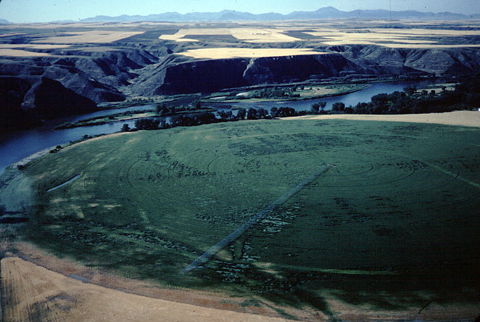
At the mouth of the Marias River, the captains would need to make an important decision. Which river fork should they follow? Their viewpoint is called today, Decision Point.
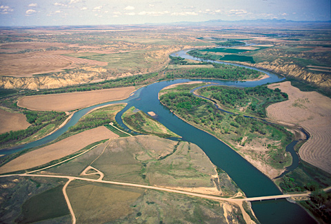
The two captains “strolled out to the top of the hights in the fork of these rivers,” from which they had “an extensive and most inchanting view.” Their vantage point was at the center of the photo, where the land seems to be touching a melon-shaped slice of island, but is actually about a hundred feet above the river. The loop pinned to the gravel road that leads to the bridge over the Missouri is the parking lot of a State Park, from which a trail leads along the highland—the “top of the hights” where Lewis and Clark stood.
Lewis admitted that the deeper waters of the north fork (entering from left in this photo) “run in the same boiling and roling manner which has uniformly characterized the Missouri throughout it’s whole course so far; its waters are of a whitish brown colour very thick and terbid, also characteristic of the Missouri.” Nevertheless, he was unconvinced that that was the true Missouri. The rest of the party, however, “with very few exceptions,” agreed with their chief waterman, Pierre Cruzatte: The north fork was the one to follow.
Late in the evening of Sunday, 2 June 1805, the Corps of Discovery’s six canoes “came too on the Lard. [larboard; their left] side in a handsome bottom of small cottonwood timber opposite to the entrance of a very considerable river.” That would have been on the point at right of center in this view, although back then it might have been a mile or so downstream.
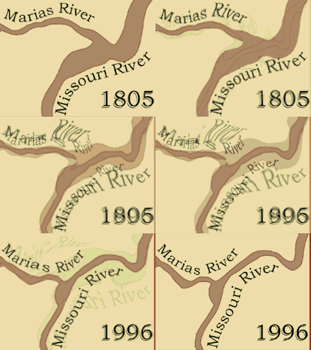
For hundreds of thousands of years these two rivers have periodically re-negotiated their meeting-place, contentiously changing their minds and their beds every few years, leaving traces of their arguments mingled in writhing ghostly contours on the broad, sandy floodplain pictured above. However, between 1890 and 1958, nine dams built on the Missouri beginning at Great Falls, 54 miles upstream, took much of the fight out of the Missouri, and pretty well quieted those old riverine disputes. Finally, in 1970 Tiber Dam, inserted eighty miles up the Marias, restrained, calmed, and nearly cleared Miss Wood’s River. Nevertheless, the true course of the Missouri can be confounding even from the air. Photographer Jim Wark admitted he flew up the north fork some twenty miles before realizing it was the Marias.
A Very Considerable River
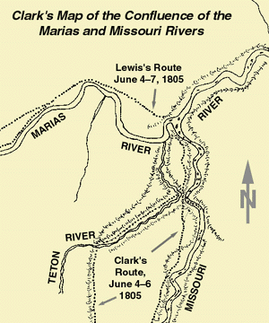
On the morning of 3 June 1805, camp was moved across the Missouri to the point on the south side of Maria’s River. Clark calculated the widths of the two rivers. First he measured a distance between two objects or stakes on the near shore; the distance had to be long enough to make a “strong” angle to the opposite shore (generally between 30 and 60 degrees). Clark then took a bearing between the two objects on the near shore and a bearing to a convenient object (tree, rock, etc.) on the far shore. He then went to the opposite end of the baseline and shot a bearing from there to the object on the far shore. That done, he made a scale drawing and determined the width of the river by measuring the scaled plot at right angles to the near-shore baseline, with allowances for mud flats, islands, or sand bars. He calculated that the left fork was 362 yards wide. The right fork, which Lewis was soon to name Maria’s River, was 200 yards wide, or 55.2% of the Missouri’s span.
The year 1805 was near the end of the Little Ice Age, a period of cooler, wetter weather that affected the Northwest beginning in the 1400s, and came to a close around 1850. The two rivers probably were near flood stage following a winter of comparatively deep snow.
Hydrogeologist Robert Bergantino, of the Montana Bureau of Mines and Geology, has scaled the widths of the two rivers by a means that Lewis would have envied. Using the most recent United States Geological Survey map, made from aerial photos taken in the late summer of 1952, Professor Bergantino plotted a series of five different measurements on each river beginning about 1/4 mile upstream from the junction. The resultant average for the Marias was 95, which was 54.2% of the average for the Missouri, 175 yards.
Although water levels on the Missouri River have been controlled for many years to prevent major flooding, and despite the impacts that irrigation and other human interference have imposed on the two rivers, their proportionate widths are almost exactly the same today as they were in 1805.
A Most ‘inchanting’ View
Before noon, Lewis wrote:
. . . Capt. C & myself stroled out to the top of the hights in the fork of these rivers from whence we had an extensive and most inchanting view; the country in every derection around us was one vast plain in which innumerable herds of Buffalow were seen attended by their shepperds the wolves; the solatary antelope which now had their young were distributed over it’s face; some herds of Elk were also seen; the verdure perfectly cloathed the ground.
The Viewpoint of the Marias River Decision
Southward they thought they discerned two mountain ranges, one behind the other, and they figured the ranges’ bearings—generally from southeast to northwest. They were almost right.
Actually there are three ranges in that direction. The nearest are the Highwood Mountains, roughly 35 miles distant. About 20 miles south of them are the Little Belt Mountains. Still farther south—and overlapping them, from Lewis and Clark’s perspective—are the Big Belt Mountains, whose peaks reach up to 9,200 feet. The northwest end of the Big Belt range is intersected by the Missouri River, flowing between the cliffs that Lewis would, 46 days in the unforeseeable future, name the “gates of the rocky mountains.”
It is difficult for most viewers today to separate the three ranges when seeing them from the explorers’ point of view, much less to estimate their bearings or distances, without at least referring to an ordinary highway map. Yet despite the captains’ misreading of the land we must admire their skill in interpreting the topography along their route, when the nearest they could come to an aerial perspective was from the highest point in the vicinity that they had the time to climb.
There are ninety different named mountain ranges in the present states of Montana and Idaho together, and one can imagine how hard it would be to tell one from another at ground level, even today. Some are well over a hundred miles long; others, such as the Moccasins, consist of just a couple of undistinguished buttes rising a little above the plain.
The captains observed that the south fork was clearer and more rapid than the north fork, and its bottom was “composed of round and flat smooth stones like most rivers issueing from a mountainous country.” They needed to reach the Rocky Mountains, where they expected to find Sacagawea‘s tribe and get horses from them, and the south fork seemed more likely to lead them in that direction. Nevertheless, just to be sure, they decided to spend a few days reconnoitering both rivers. Meanwhile, Lewis named the north fork for his cousin, Maria Wood.
Handsome Situation
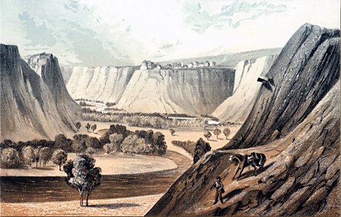
The Marias River
by John Mix Stanley (1814–1872)
Special Collections, K. Ross Toole Archives, The University of Montana, Missoula
Chromolithograph from Reports of Explorations and Surveys, to Ascertain the Most Practicable and Economical Route for a Railroad from the Mississippi River to the Pacific Ocean (1855-1861), Vol. 12, Plate 26.
On the height at center the artist has imagined a fort or trading post such as Lewis and Clark recommended for the mouth of the Marias. Fort Piegan—named for the Piegan tribe of the Blackfeet Nation, whom the traders hoped to attract—was built there in the winter of 1831 by James Kipp of John Jacob Astor’s American Fur Company, to tap into the regional Indian trade, but it lasted less than a year before Blood Indian warriors burned it down. The following year the manager of Astor’s Upper Missouri Outfit, headquartered at Fort Union, sent an experienced trader, Jacob Berger, to establish a new satellite post eight miles up the Missouri from the mouth of the Marias. Berger named it Fort McKenzie in honor of his boss, Kenneth McKenzie. Despite the accidental arrival of a devastating smallpox epidemic in 1837, the post thrived until 1844, when an ugly incident precipitated by the new management, Francois Chardon and his lieutenant, Alexander Harvey, made it necessary to abandon the place in early April. Sometime after that its structures were burned by unknown persons.
It must have been the morning of 3 June 1805, as they stood on the point west of Maria’s River, looking over the land, that the two captains agreed the promontory opposite them would make “a proper and handsome situation” for a trading post. On his sketch-map of the vicinity, Clark made note of it for future reference.
But why did they even bother with the thought, since they had no evidence that any Indians—at least none they had talked to—seemed to know of the place? Simply because they were routinely observant, and in topographic terms alone this appeared to be a prime location.
Thirteen months later, Lewis was to capitalize on the idea. Returning to Maria’s River for asecond and more extensive look, he and his three companions had an “interview” one evening with eight Piegan men. That was 195 miles upstream on the south fork of the Marias, now known as the Two Medicine River. On the defensive, but still in possession of his diplomatic savvy, he allowed himself the advantage of a couple of little white lies.
I told these people . . . that I had come in surch of them in order to prevail on them to be at peace with their neighbours particularly those on the West side of the mountains and to engage them to come and trade with me when the establishment is made at the entrance of this river.
The first attempt to build a post at the mouth of the Marias was made in 1831, at the height of the fur-trade era. The last attempt was made in 1866, when Missouri River commerce was at its peak.
Celestial Observations
The Lewis and Clark Expedition was a business trip. For more than 300 years European explorers and, lately, American traders, had been steadily pushing the boundaries of the known world outward into the previously unknown. Within those new boundaries they found other peoples, which meant new places to sell things, and new goods their own customers at home might like to buy. Thus businessmen engaged in trade beyond the boundaries of their own countries began to think globally. Accordingly, they needed to be able to identify new places with certainty, and to know a place meant to know its location by the numbers—by its address on the global grid. That is why Thomas Jefferson instructed Lewis:
Beginning at the mouth of the Missouri, you will take careful observations of latitude & longitude, at all remarkeable points on the river, & especially at the mouths of rivers, at rapids, at islands, and other places & objects distinguished by such natural marks & characters of a durable kind, as that they may with certainty be recognised hereafter.
So Lewis was given a gigantic task, and he worked at it diligently, looking for answers from the sky, night and day.
In 1803, when preparations for the expedition were under way, only a very few locations on their projected route between St. Louis and the Pacific Ocean were known, in the new sense. In 1792 the Boston trading-ship captain Robert Gray (1755-1806) determined the latitude (46 degrees, 39 minutes North) and longitude of the mouth of the Columbia River, as well as points along the lower Columbia River, including today’s Portland, Oregon. The following year the Canadian fur trader David Thompson did the same for the Mandan Villages: 47 degrees and some minutes North latitude; 101 degrees and some minutes West longitude. The rest of the Northwest was, cartographically speaking, afloat somewhere in terrestrial space.
The mouth of the river Lewis called Maria’s was one of those “remarkable points,” all the more so because of its potential as a trading-post site. He figured it was at 47 degrees, 46 minutes, 50.2 seconds North, which is about nine miles south of where it “really” was. His error is partly attributable to his assumption that the earth is a perfect sphere, whereas actually there is about a 27-mile difference between equatorial and polar circumference, and the length of a degree varies correspondingly.[1]For a deeper analysis, see Marias River Observations, by Robert N. Bergantino.
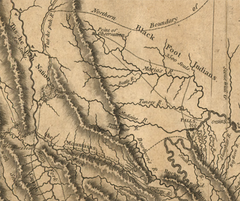
Clark’s 1814 Map
Miss Wood’s Own River
Detail from Clark’s 1814 map
To see labels, point to the map.
American Philosophical Society, Philadelphia.
All in all, this 1814 visualization of the region between the mouth of the Marias River and the Rocky Mountain Front is less accurate than it might have been had Clark himself ever set foot on the land. Only the course of Maria’s River is reasonably true. But Lewis, who explored its basin extensively, had been dead five years before this map reached its final draft, which may explain how Clark came to show the Marias, the Medicine (Sun River) and the Dearborn River, as having their sources deep within the mountains, rather than on the steep east face of the Rocky Mountain Front. The route of Lewis’s 1806 shortcut from Travelers’ Rest to the Great Falls of the Missouri is correct until it reaches the east side of the mountains. From there it traces an Indian road rather than Lewis’s track. The Skishaquaw (Shishequaw) River —which doesn’t really qualify as a river, but is a very respectable creek—waters the base of the landmark Lewis identified by name as he and his small contingent marched northward along the Old North Trail.
Finally, notice the line marking the “Northern Boundary of LOUISIANA.” Whatever became of Lewis’s intuition that the Milk River valley would define this part of the Missouri river Basin’s northern boundary? That was a really good guess. Unfortunately, he didn’t have time to confirm it, so, when it came to finishing his comprehensive map of the western part of Louisiana, he relied on his own guess as to where it began, which was that the Milk flowed nearly due south from a source up near the Assinniboin River. And that guess was wrong!
Nevertheless, when one compares this conception with the map Nicholas King prepared for the explorers from the most reliable sources then known, which resulted in a simple articulation of empty spaces, it is clear that Clark’s effort, for all its faults, represented a quantum leap in the visualization of this corner of the High Plains.
Decision Point is a High Potential Historic Site along the Lewis and Clark National Historic Trail managed by the U.S. National Park Service. The site is open to the public and managed by the Bureau of Land Management.—ed.
Notes
| ↑1 | For a deeper analysis, see Marias River Observations, by Robert N. Bergantino. |
|---|
Experience the Lewis and Clark Trail
The Lewis and Clark Trail Experience—our sister site at lewisandclark.travel—connects the world to people and places on the Lewis and Clark Trail.
Discover More
- The Lewis and Clark Expedition: Day by Day by Gary E. Moulton (University of Nebraska Press, 2018). The story in prose, 14 May 1804–23 September 1806.
- The Lewis and Clark Journals: An American Epic of Discovery (abridged) by Gary E. Moulton (University of Nebraska Press, 2003). Selected journal excerpts, 14 May 1804–23 September 1806.
- The Lewis and Clark Journals. by Gary E. Moulton (University of Nebraska Press, 1983–2001). The complete story in 13 volumes.
