From atop Decision Point, the view of the Missouri and swollen Marias River confuses everyone as to which is the main river. To help the captains decide, scouts are sent up each river. Camp is moved to the north side of the Missouri, and many of the enlisted men recover from having to tow the boats the past few days.
Which is the Main River?
by Yellowstone Public Radio[1]Originally aired weekdays by Yellowstone Public Radio during the Bicentennial observance of 2003-2006. Narrated by Hal Hansen. Scripts by Whit Hansen and Ed Jacobson. Produced by Leni Holliman. © … Continue reading
View from Decision Point
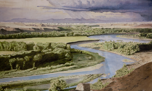
Interpretive sign at Decision Point. Photo and digital restoration of the heavily damaged sign by Kristopher K. Townsend.
“extensive and inchanting view”
Capt. C & myself stroled out to the top of the hights in the fork of these rivers from whence we had an extensive and most inchanting view; the country in every derection around us was one vast plain in which innumerable herds of Buffalow were seen attended by their shepperds the wolves; the solatary antelope which now had their young were distributed over it’s face; some herds of Elk were also seen; the verdure perfectly cloathed the ground, the weather was pleasent and fair;
—Meriwether Lewis
Which is the Main River?
An interesting question was now to be determined; which of these rivers was the Missouri . . . . accordingly we dispatched two light canoes with three men in each up those streams; we also sent out several small parties by land with instructions to penetrate the country as far as they conveniently can permiting themselves time to return this evening and indeavour if possible to discover the distant bearing of those rivers by ascending the rising grounds.
—Meriwether Lewis
Moving Camp
This morning early we passed over and formed a camp on the point formed by the junction of the two large rivers. here in the course of the day I continued my observations as are above stated.
—Meriwether Lewis
Bruised Feet
Those who have remained at camp today have been busily engaged in dressing skins for cloathing, notwithstanding that many of them have their feet so mangled and bruised with the stones and rough ground over which they passed barefoot, that they can scarcely walk or stand; at least it is with great pain they do either.
—Meriwether Lewis
Other Sightings
Weather Diary
State of the thermometer at rise
Weather Wind at State of the thermometer at 4 OC. P.M. Weather Wind at 4 OC. P. M. State of river 46 [above 0] fair S W 60 [above 0] fair S W Cought the 1st White Chub, and a fish resembling the Hickory Shad in the Clear Stream
—Meriwether Lewis and William Clark[2]To assist the reader, the editor of this web page has omitted the date column, merged the “State of the river” columns, and spelled out some abbreviations.
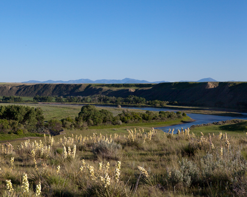
Three Decision Point Views
Highwood Mountains from Decision Point
to the South we saw a range of lofty mountains which we supposed to be a continuation of the S. Mountains, streching themselves from S. E. to N. W. terminating abbrubtly about S. West from us; these were partially covered with snow; behind these Mountains and at a great distance, a second and more lofty range of mountains appeared to strech across the country in the same direction with the others, reaching from West, to the N of N. W., where their snowey tops lost themselves beneath the horizon. this last range was perfectly covered with snow.
—Meriwether Lewis
© 28 June 2013 by Kristopher K. Townsend. Permission to use granted under the Creative Commons Attribution-Share Alike 4.0 International license.
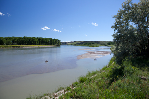
Teton (left) and Marias (right) Rivers
They came down this little river and found it a boald runing stream of about 40 yds. wide containg much timber in it’s bottom, consisting of the narrow and wide leafed cottonwood with some birch and box alder undrgrowth willows rosebushes currents &c.
—Meriwether Lewis
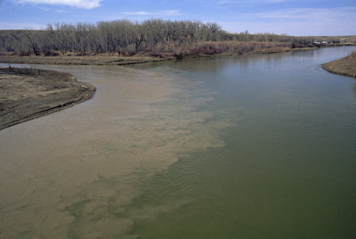
Missouri (left) and Marias (right) Confluence
the South fork is perfectly transparent runds very rappid but with a smoth unriffled surface it’s bottom composed of round and flat smooth stones like most rivers issuing from a mountainous country.
—Meriwether Lewis
© 28 June 2013 by Kristopher K. Townsend. Permission to use granted under the Creative Commons Attribution-Share Alike 4.0 International license.
Above: The gray stream of water on the right is from the Marias.
Experience the Lewis and Clark Trail
The Lewis and Clark Trail Experience—our sister site at lewisandclark.travel—connects the world to people and places on the Lewis and Clark Trail.
Plan a trip related to June 3, 1805:


Decision Point is a High Potential Historic Site along the Lewis and Clark National Historic Trail managed by the U.S. National Park Service. The site is open to the public and managed by the Bureau of Land Management.
Notes
| ↑1 | Originally aired weekdays by Yellowstone Public Radio during the Bicentennial observance of 2003-2006. Narrated by Hal Hansen. Scripts by Whit Hansen and Ed Jacobson. Produced by Leni Holliman. © 2003 by Yellowstone Public Radio. |
|---|---|
| ↑2 | To assist the reader, the editor of this web page has omitted the date column, merged the “State of the river” columns, and spelled out some abbreviations. |

