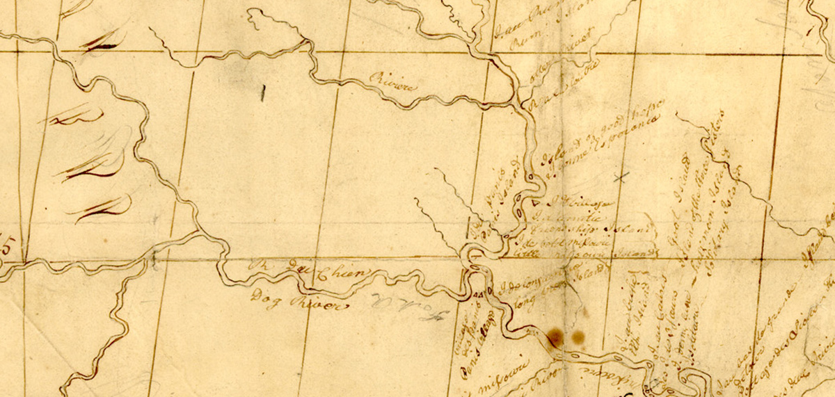
Mackay and Evans Map (Cheyenne River Detail)
Courtesy http://memory.loc.gov/gmd/gmd412/g4127/g4127m/ct000583.sid.
“Map of Missouri River and Vicinity from St. Charles to the Mandan Villages of North Dakota made by James Mackay (1759-1822) with the assistance of John Evans (1770-1799).” This detail shows Missouri River roughly between the Platte and Kansas Rivers.
In January 1796, James Mackay of the Commercial Company for the Discovery of the Nations of the Upper Missouri, a Spanish enterprise commonly called the Missouri Company, made a voyage up the Missouri River, accompanied by James Evans (1770-1799). The most important material outcome of their expedition was a remarkably precise and detailed map of the Missouri River from St. Charles to the Mandan villages, which quickly was recognized as the most accurate made up to that time. Mackay, who had turned back at Fort Charles, the trading post he built on the Missouri somewhere between the mouths of the Platte and Niobrara Rivers, drew the final version. It included many of the early French names of the Missouri’s tributaries. Thomas Jefferson sent a copy of it to Meriwether Lewis in 1803. It was one of the most valuable tools the captains had.
Related Pages
Trail Graffiti
by Joseph A. Mussulman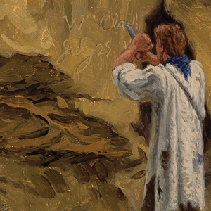
Members of the Lewis and Clark expedition carved, burned, or painted their names or initials and the dates when they did so, more than fourteen times according to the journals. They were practicing what had long been European explorers’ legitimate means for claiming dominion over other people’s land.
December 28, 1803
Mackay and Evans journals
At Wood River, Clark reports “nothing remarkable to day”. Elsewhere, Lewis tells President Jefferson that he has a census of Louisiana and journals and maps from explorers John Evans and James Mackay.
September 14, 1804
Pronghorn and jackrabbit
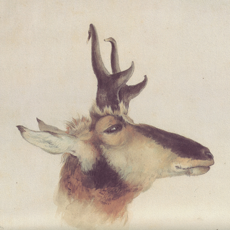
As the men move the boats up the Missouri below present Oacoma, South Dakota, Clark kills a pronghorn, and Pvt. Shields kills a white-tailed jackrabbit. In his natural history notes, Lewis describes each.
Fur Trade after the Expedition
by W. Raymond Wood
The Louisiana Purchase and the lure of its beaver population led to a veritable flood of traders and trappers moving toward the Upper Missouri and the Northern Rocky Mountains and the slow abandonment of the overland trade in the United States by Canadian and British interests.
August 4, 1804
Moses Reed is missing
The expedition travels fifteen miles up the Missouri and encamps southwest of present Modale, Iowa. The captains record yesterday’s speech to the Otoes, and Pvt. Moses Reed—who had headed back to the previous night’s camp to retrieve his knife— does not return as expected. Lewis collects a specimen of snow-on-the-mountain, and they pass an old trading house where Pvt. Cruzatte had worked.
Mapping the Falls
by Joseph A. Mussulman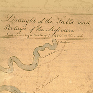
The falls of the Missouri comprised the most remarkable of all the “remarkeable points” that Clark described and mapped in conscientious obedience to an order from Thomas Jefferson to take observations “with great pains & accuracy.”
January 10, 1804
Icy river crossing
Pvt. J. Field passes between sheets of ice to cross the Mississippi. Clark comments on the maps and information obtained from trader James Mackay who recently made a surveying trip up the Missouri River.
Lewis’s Branding Iron
by Joseph A. Mussulman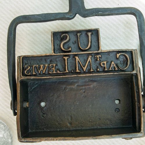
Lewis may have had this branding iron custom-made before he left the East, perhaps at Harpers Ferry, although there is no mention of it in existing records. Such tools commonly were used for marking wooden packing crates and barrels, and on leather bags, until the early 20th century.
Lost Hunters
by Joseph A. Mussulman
Every hunter, after following the land instead of the river, had to somehow end his day within sight or sound of the party’s camp at a location which no one could have known in advance. They were not always successful.
Missouri River Fur Trade
by Joseph A. Mussulman, W. Raymond Wood
The Corps of Discovery had been, as James Ronda phrased it, “only the latest in a long series of traders and travelers” to visit the tribes living along the Missouri. The Mandans had been visited in 1738 by la Vérendrye from his base on the Assiniboine River.
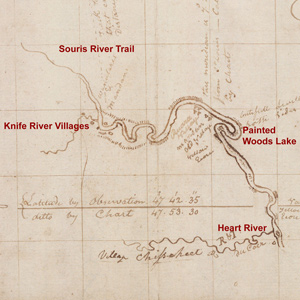
Clark’s Fort Mandan Maps
by Joseph A. Mussulman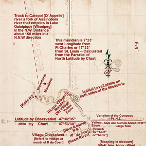
While wintering over at Fort Mandan, Clark made a series of maps based on Indian information and previous traders such as John Evans and François Larocque.
June 13, 1805
"sublimely grand specticle"
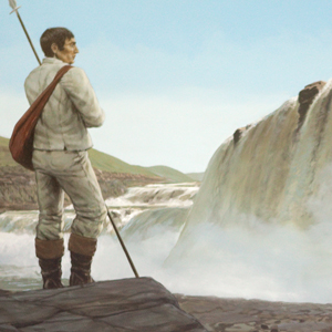
Lewis reaches the Grand Fall of Missouri and marvels at its ‘sublimely grand spectacle’. Several miles downriver, Clark gives Sacagawea a dose of salts as a purgative and the enlisted men move the boats 13 miles up the river.
Near the mouth of the Ohio at Fort Massac, General James Wilkinson has questions about the delegation of Native Peoples who recently arrived aboard the expedition’s barge (keelboat).
Experience the Lewis and Clark Trail
The Lewis and Clark Trail Experience—our sister site at lewisandclark.travel—connects the world to people and places on the Lewis and Clark Trail.
![]()
Discover More
- The Lewis and Clark Expedition: Day by Day by Gary E. Moulton (University of Nebraska Press, 2018). The story in prose, 14 May 1804–23 September 1806.
- The Lewis and Clark Journals: An American Epic of Discovery (abridged) by Gary E. Moulton (University of Nebraska Press, 2003). Selected journal excerpts, 14 May 1804–23 September 1806.
- The Lewis and Clark Journals. by Gary E. Moulton (University of Nebraska Press, 1983–2001). The complete story in 13 volumes.
This site is provided as a public service by the
![]()
Lewis and Clark Trail Alliance
with additional funding from the following:

