Jim Wark
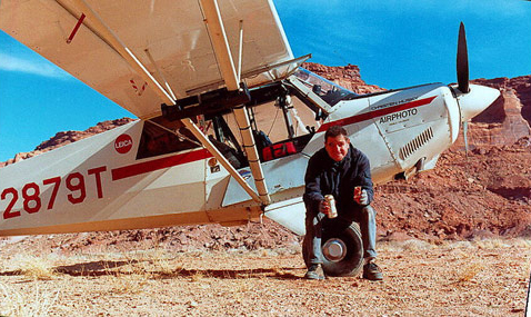
© 2000 Airphoto
I am an aviator, a mining engineer and a photographer, in that order. Or maybe it’s the other way around. My life’s work has been in aviation and earth sciences, and combining these interests with an inherited instinct for photography has fulfilled my deepest ambition. My Christen Husky airplane has prowled North and Central America, from the Arctic shores of Alaska to the tropical jungles of Costa Rica, and from the remote and harsh Ungava Peninsula of Labrador to the balmy Island of Granada.
On the Morning of Friday, May 14, 1999, I began my westward retracing of the Lewis and Clark route from St. Louis to the Pacific Ocean in my Christen A-1 Husky, a single-engine, high-wing, bush-type airplane. The day marked the 195th anniversary of the departure of the Corps of Discovery from this point. I had spent five months planning and plotting the route, and I had entered geographic coordinates of known Corps of Discovery campsites and points of interest into the airplane’s Global Positioning System (GPS). I also entered many potential camping sites. The nights spent camping with my airplane are treasured times, and I put much thought into selecting locations.
The National Park Service reckons the distance of the Lewis and Clark Trail at 3,700 miles. My GPS flight plan showed 2,473 miles. The point-to-point traverse of the GPS-planned route eliminated many miles of river and trail meandering, so the distances are not necessarily at odds. The trip took seven flying days, with eighty hours of flight time. For Lewis and Clark, the time in actual travel was twelve months. In 2001, at the urging of Dr. Mussulman, I flew the eastern portion of the Lewis and Clark route, as well as all the principal side journeys.
My trips over the Lewis and Clark Trail produced a total of 3,182 images, all of which were shot with Leica 35mm cameras and Fuji Velvia film. As has been the case with nearly all of my aerial photos, the heights at which the pictures were shot varied from 500 to 3000 feet, with most taken between 1000 and 1500 feet. The average person’s view of the earth from six miles high in a commercial airliner, or even from one mile up in a small plane, bears no resemblance whatsoever to the experience of flying alone, low and slow, over the incredible, changing texture of the earth below. It is touching the face of the land and sensing its texture, habitations and geology. It is a close encounter with weather and terrain as a single element.
My single-engine airplane is loaded with a large collection of cameras, lenses, camping equipment and provisions capable of sustaining an adventure of several weeks. The only replenishments needed are aviation fuel and fresh water. Nights are spent sleeping under the wing—or sometimes on the well-worn couch of a friendly small-airport manager. A normal working day is eight hours of flying, resulting in 300 to 400 photos per day. There are times when fair weather prevails for weeks at a time. At other times, low clouds and storms have kept me grounded for several days at one camp or another.
There are countless opportunities to capture images from the air of human activity and achievement, but the biggest rush comes from nature: A special light, a dramatic cloud, an unusual expression of geology, a craggy peak, a reflecting lake, a splendid palate of texture and color. A juxtaposition of any of these things, including human activity, is what makes aerial photography a unique experience for the photographer and for those who view it.
Jim Wark was the 2006 recipient of the first annual Epson Professional Photographers’ award. In March 2007, two of his photos were among 103 chosen from 9,968 world-wide entries for the San Diego Lyceum’s 2007 “Art of Photography” exhibition.
To date, Jim’s published works are:
- A Field Guide to Sprawl, with text by Dolores Hayden (128 pages, 75 aerial photos), $24.
- America, Flying High, with text by the photographer (650 pages, 600 aerial photos), $25.
- Colorado: An Aerial Geographer of the Highest State, with text by Tom Huber (140 pages, 110 aerial photos), $45.
- Discovering Lewis & Clark From the Air, with text by Joseph Mussulman (261 pages, 111 aerial photos), $25 hardcover; $22 paper.
All are available direct from the photographer. To order, email [email protected], or call 719.545.1051. Add $5 for postage.
See also Jim’s on-line Airphoto North America gallery, containing almost 10,000 images selected from his 100,000-image stock library.
Featured Photographs by Jim Wark
The Lewis and Clark River
Coast Range winter
by Joseph A. Mussulman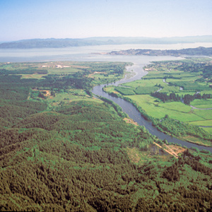
During their time at the coast, the Corps saw only six sunny days; the rest brought clouds, fog, rain, and a little snow. Fifty-three were partly clear. That’s a normal winter on the west slopes of the Coast Range.
The Salt Works by Air
Seaside, Oregon
by Joseph A. Mussulman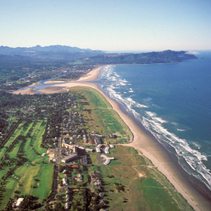
Here they built an oven of stones and, day and night for a month and a half, scooped perhaps 1,400 gallons of water from the surf, boiling it down to about twenty-eight gallons of salt.
Over Tillamook Head
Clark's point of view
by Joseph A. Mussulman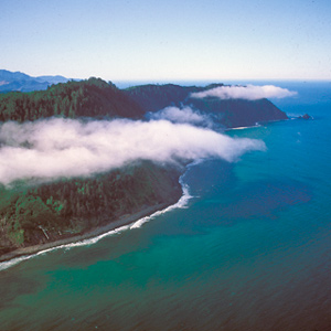
After passing the salt works and continuing along the “round Slippery Stones under a high hill,” Clark related, “my guide made a Sudin halt, pointed to the top of the mountain and uttered the word Pe Shack which means bad, and made Signs that we . . . must pass over that mountain.
Ecola
Whale tale
by Joseph A. Mussulman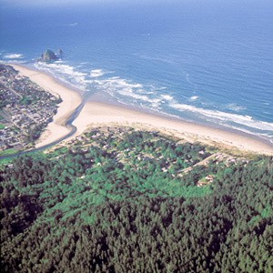
By the time Clark and his party got to present-day Cannon Beach, Oregon, on 8 January 1806, the locals had picked the dead whale’s 105-foot-long carcass clean.
Long Camp Observations
25 May–9 June 1806
by Robert N. Bergantino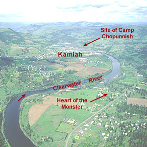
An analysis of Lewis’s celestial observations made during their stay at Long Camp near present-day Kamiah, Idaho.
The Salmon and Snake Villages
Side trip
by Joseph A. Mussulman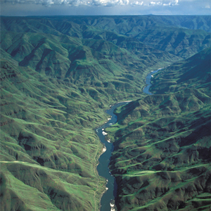
When the captains saw Nez Perces with several fresh chinook salmon, “fat and fine,” which the Indians said came from “Lewis’s River,” known today as the Salmon River, they dispatched Sgt. John Ordway and two privates to buy some.
Ordway’s Fishing Trip
No mere half day
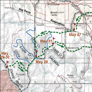
On 27 May 1806, Sergeant John Ordway, accompanied by Privates Frazer and Weiser, left Long Camp under orders to ride over to “the East branch of the Salmon River. The spring run of chinooks had not yet appeared on the Clearwater, so the three were to buy some fresh fish.
Rocky Point Views
One last view
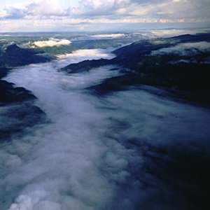
They crossed over the peak without pausing for one last view of “those tremendious mountanes . . . in passing of which,” Clark would assert two days later, “we have experienced Cold and hunger of which I shall ever remember.”
Passing Hell’s Gate
Up the Blackfoot River
by Joseph A. Mussulman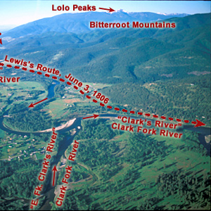
The continuation of the Northern Nez Perce Trail led from their camp at Travelers’ Rest to the plains near the Great Falls of the Missouri, saving hundreds of miles from the expedition’s 1805 route.
Seaman’s Creek
Clues to his name
by Joseph A. Mussulman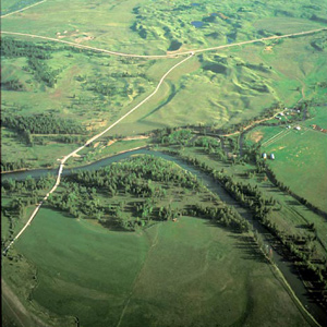
Twenty-eight and one-half miles upriver from their camp of 4 July 1806 the Indian road crossed a stream Lewis named after William Werner. At mile 31, they camped near the mouth of a stream the captain named after his dog, Seaman.
The Blackfoot River by Air
Prairie of the knobs
by Joseph A. Mussulman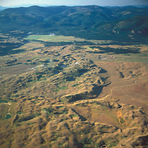
On 6 July 1806, Lewis’s eleven-man party had broken camp at the mouth of a Blackfoot River tributary they named Seamans Creek, after, and headed on up the river along the “road” that Indians living in the Rocky Mountains called the Cokahlahrishkit—the Road to the Buffalo.
Lewis and Clark Pass by Air
Dividing ridge
by Joseph A. Mussulman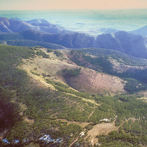
Lewis and Clark Pass is six miles north of Rogers Pass, where Montana Highway 200 crosses the Continental Divide. The concept of the continental divide, and the term itself, would emerge only after another fifty years of western exploration.
Lewis and Clark Pass
A shorter way
by Joseph A. Mussulman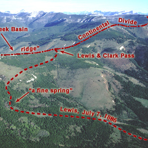
Sergeant Gass recorded that on 7 July 1806, Lewis’s detachment took a three-hour lunch break and then proceeded four miles, “when we came to the dividing ridge between the waters of the Missouri and Columbia.”
The Dearborn River Crossing
Along the Old North Trail
by Joseph A. Mussulman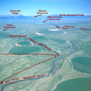
Shortly after crossing the Dearborn River, Lewis saw that the Indian road “continued along the foot of the mountain to the West of north” so he and his men cut northeast across the “tolerably level” plain toward the Sun River.
Down the Sun River
Through the "Battle Hills"
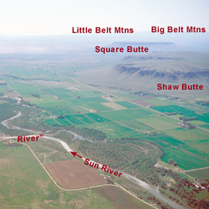
Meriwether Lewis has tempted fate and his “chapter of accidents” again by re-entering the domain of the people he had repeatedly been advised to steer clear of—the Blackfeet, Siksikas, Atsinas, and Assiniboines.
Return to the Portage
Lewis's hiatus
by Joseph A. Mussulman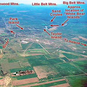
One can almost feel the thrill of wakening to a clear early-summer dawn at this powerful place on the pregnant plains where the Medicine meets the Missouri. Here began a five-day hiatus in Lewis’s master plan for his junket to find the boundary of British-held Canada.
Bozeman Pass
Of great service
by Joseph A. Mussulman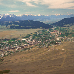
Clark reported, “the indian woman who has been of great Service to me as a pilot through this Country recommends a gap in the mountain more South which I shall cross.” This was one of the few times Sacagawea acted as the guide.
Yellowstone Canoe Camp by Air
Horse thieves
by Joseph A. Mussulman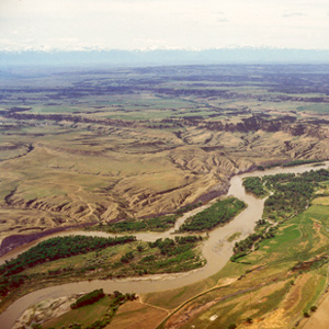
Clark’s party made camp at today’s Park City, Montana, and settled in to build the new canoes and attend to other business. While a few of the men took turns with the three axes they had along, some of the rest, being nearly naked, made elk- and deer-skin clothing.
Yellowstone Canoe Camp
by Joseph A. Mussulman
One week and a hundred miles after starting down the Yellowstone River, Clark finally found cottonwood trees large enough for building canoes. That night some Indians made off with half their horses.
Camp Disappointment
The northernmost extent
by Joseph A. Mussulman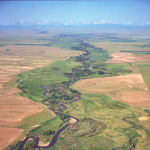
In 1806, Lewis, Drouillard, Joe Field, and Reubin Field made a second excursion up the Marias, this time on horseback. The four men reached the northernmost point of the Expedition’s exploration on 22 July 1806, camping on the south side of today’s Cut Bank Creek.
Pryor Creek
Ill-fated mission
by Joseph A. Mussulman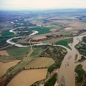
The stream Clark named for Nathaniel Pryor meanders from its montane sources in the mountain range that now bears Pryor’s name to join the Yellowstone River in the area where Pryor began his ill-fated diplomatic mission.
Apsáalooke Country
by Joseph A. Mussulman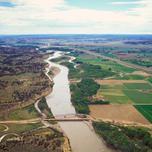
The Crow People called themselves Apsáalooke, sometimes heard as Absarokas or Absalookas, or “Children of the Large-beaked Bird.” Various early white travelers transcribed or defined the name differently, but the Apsáalooke maintain it refers to the raven. One of the oldest and most famous landmarks on Lewis and Clark’s route, now known officially, but erroneously, as Pompeys Pillar or, among the Apsáalooke, Iish-biia ah-naac’he’.
Pompeys Pillar
Pompy's Tower
by Joseph A. Mussulman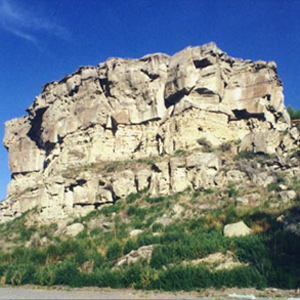
On 25 July 1806, Clark and his contingent of nine men, plus York, Toussaint Charbonneau, Sacagawea, and little Jean Baptiste, arrived at “a remarkable rock Situated in an extensive bottom, on the Star[boar]d. [south] Side of the river.”
Fight on the Two Medicine
An "accedental interview"
by Joseph A. Mussulman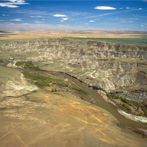
The Indians invited the Americans to share a campsite that night. At daybreak, despite the soldiers’ watchfulness, the Indians tried to steal the Americans’ guns and horses. That immediately erupted into a skirmish.
The Lower Yellowstone
A promising location
by Joseph A. Mussulman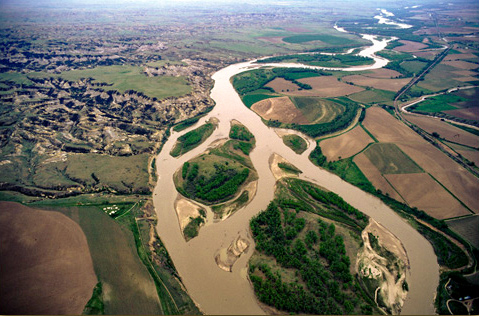
On 30 July 1806 Clark and his party camped near the mouth of the War har sah, or Powder River. He summarized the Yellowstone’s attractions, directing most of his attention toward opportunities for immediate expansion of the fur trade.
St. Louis by Air
The western gate
by Joseph A. Mussulman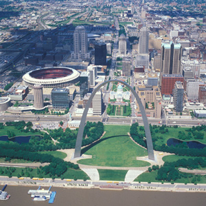
The expedition arrived on 7 December 1803, witnessed the transfer of Louisiana from Spain to the United States, and metaphorically passed through its western gate on 14 May 1804. They would not return until 23 September 1806.
Bighorn Sheep Encounters
by Joseph A. Mussulman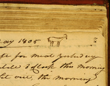
During a reconnaissance assignment eight miles up the Yellowstone River on 26 April 1805, Joseph Field became the first member of the Corps to glimpse a live bighorn sheep.
Experience the Lewis and Clark Trail
The Lewis and Clark Trail Experience—our sister site at lewisandclark.travel—connects the world to people and places on the Lewis and Clark Trail.
Discover More
- The Lewis and Clark Expedition: Day by Day by Gary E. Moulton (University of Nebraska Press, 2018). The story in prose, 14 May 1804–23 September 1806.
- The Lewis and Clark Journals: An American Epic of Discovery (abridged) by Gary E. Moulton (University of Nebraska Press, 2003). Selected journal excerpts, 14 May 1804–23 September 1806.
- The Lewis and Clark Journals. by Gary E. Moulton (University of Nebraska Press, 1983–2001). The complete story in 13 volumes.
This site is provided as a public service by the
Lewis and Clark Trail Alliance
with additional funding from the following: