Jim Wark
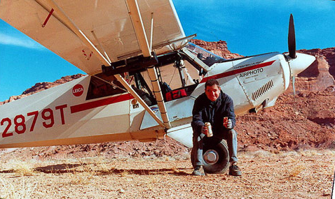
© 2000 Airphoto
I am an aviator, a mining engineer and a photographer, in that order. Or maybe it’s the other way around. My life’s work has been in aviation and earth sciences, and combining these interests with an inherited instinct for photography has fulfilled my deepest ambition. My Christen Husky airplane has prowled North and Central America, from the Arctic shores of Alaska to the tropical jungles of Costa Rica, and from the remote and harsh Ungava Peninsula of Labrador to the balmy Island of Granada.
On the Morning of Friday, May 14, 1999, I began my westward retracing of the Lewis and Clark route from St. Louis to the Pacific Ocean in my Christen A-1 Husky, a single-engine, high-wing, bush-type airplane. The day marked the 195th anniversary of the departure of the Corps of Discovery from this point. I had spent five months planning and plotting the route, and I had entered geographic coordinates of known Corps of Discovery campsites and points of interest into the airplane’s Global Positioning System (GPS). I also entered many potential camping sites. The nights spent camping with my airplane are treasured times, and I put much thought into selecting locations.
The National Park Service reckons the distance of the Lewis and Clark Trail at 3,700 miles. My GPS flight plan showed 2,473 miles. The point-to-point traverse of the GPS-planned route eliminated many miles of river and trail meandering, so the distances are not necessarily at odds. The trip took seven flying days, with eighty hours of flight time. For Lewis and Clark, the time in actual travel was twelve months. In 2001, at the urging of Dr. Mussulman, I flew the eastern portion of the Lewis and Clark route, as well as all the principal side journeys.
My trips over the Lewis and Clark Trail produced a total of 3,182 images, all of which were shot with Leica 35mm cameras and Fuji Velvia film. As has been the case with nearly all of my aerial photos, the heights at which the pictures were shot varied from 500 to 3000 feet, with most taken between 1000 and 1500 feet. The average person’s view of the earth from six miles high in a commercial airliner, or even from one mile up in a small plane, bears no resemblance whatsoever to the experience of flying alone, low and slow, over the incredible, changing texture of the earth below. It is touching the face of the land and sensing its texture, habitations and geology. It is a close encounter with weather and terrain as a single element.
My single-engine airplane is loaded with a large collection of cameras, lenses, camping equipment and provisions capable of sustaining an adventure of several weeks. The only replenishments needed are aviation fuel and fresh water. Nights are spent sleeping under the wing—or sometimes on the well-worn couch of a friendly small-airport manager. A normal working day is eight hours of flying, resulting in 300 to 400 photos per day. There are times when fair weather prevails for weeks at a time. At other times, low clouds and storms have kept me grounded for several days at one camp or another.
There are countless opportunities to capture images from the air of human activity and achievement, but the biggest rush comes from nature: A special light, a dramatic cloud, an unusual expression of geology, a craggy peak, a reflecting lake, a splendid palate of texture and color. A juxtaposition of any of these things, including human activity, is what makes aerial photography a unique experience for the photographer and for those who view it.
Jim Wark was the 2006 recipient of the first annual Epson Professional Photographers’ award. In March 2007, two of his photos were among 103 chosen from 9,968 world-wide entries for the San Diego Lyceum’s 2007 “Art of Photography” exhibition.
To date, Jim’s published works are:
- A Field Guide to Sprawl, with text by Dolores Hayden (128 pages, 75 aerial photos), $24.
- America, Flying High, with text by the photographer (650 pages, 600 aerial photos), $25.
- Colorado: An Aerial Geographer of the Highest State, with text by Tom Huber (140 pages, 110 aerial photos), $45.
- Discovering Lewis & Clark From the Air, with text by Joseph Mussulman (261 pages, 111 aerial photos), $25 hardcover; $22 paper.
All are available direct from the photographer. To order, email [email protected], or call 719.545.1051. Add $5 for postage.
See also Jim’s on-line Airphoto North America gallery, containing almost 10,000 images selected from his 100,000-image stock library.
Featured Photographs by Jim Wark
The Sun River by Air
"Curious adventures"
by Joseph A. Mussulman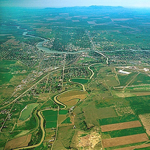
The day’s “succession of curious adventures wore the impression on my mind of inchantment,” he mused. “It now seemed to me that all the beasts of the neighbourhood had made a league to distroy me.”
Rainbow Falls by Air
"Pleasingly beautifull"
by Joseph A. Mussulman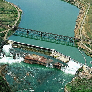
After briefly contemplating the Crooked Falls on 14 June 1805, Lewis followed the sound of “a tremendious roaring” to “one of the most beautifull objects in nature,” a fifty-foot-high cascade “with an edge as regular and as straight as if formed by art.”
Crooked Falls by Air
A "thousand conjectures"
by Joseph A. Mussulman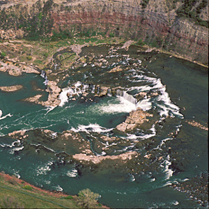
After passing “one continued rappid and three small cascades of abut for or five feet each,” Lewis “arrived at a fall of about 19 feet,” which he suitably named “the crooked falls” and proceeded to describe its geometry.
Lower Portage Camp
Good news, bad news
by Joseph A. Mussulman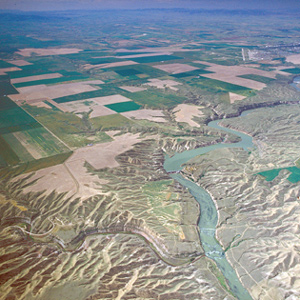
By the evening of 15 June 1805, Clark had gotten the canoes and the white perogue as close to the Great Falls as possible, and the next afternoon Lewis joined him at the “lower portage camp,” a mile below the mouth of Belt Creek.
Tower Rock
First Gate of the Rocky Mountains
by Joseph A. Mussulman, Robert N. Bergantino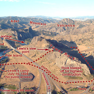
“at this place there is a large rock of 400 feet high wich stands immediately in the gap which the missouri makes on it’s passage from the mountains.”
Oxbow Bend
Land and water
by Joseph A. Mussulman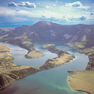
On 19 July 1805, Lewis ‘doubled’ around Oxbow Bend, then 30 feet lower and maybe one-fourth as wide as it is today. Behind the river’s curve, an ancient landmark on the Indian Old North Trail, still stands out.
Gates of the Mountains
The second gate
by Joseph A. Mussulman, Robert N. Bergantino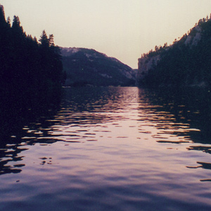
Late in the day on 19 July 1805, Lewis and his party entered a canyon between “the most remarkable clifts that we have yet seen.” They seemed to rise “from the waters edge on either side perpendicularly to the hight of 1200 feet.”
Three Forks of the Missouri
Essential geographic point
by Joseph A. Mussulman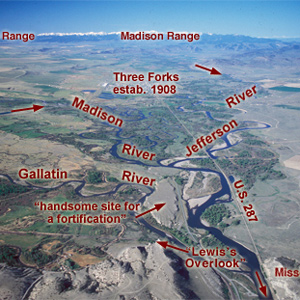
Lewis and his canoes slowly approached the forks, “the current still so rapid that the men are in a continual state of their utmost exertion to get on, and they begin to weaken fast from this continual state of violent exertion.” He described the “extensive and beatifull plains and meadows.”
The Headwaters by Air
Essential point
by Joseph A. Mussulman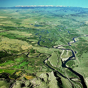
Upon the Corps’s arrival at this confluence on 25 July 1805, Lewis quickly recognized it as “an essential point in the geography of this western part of the Continent.”
The Jefferson River
Third gap
by Joseph A. Mussulman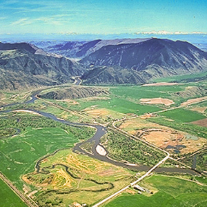
On the first of August 1805, Clark and the expedition’s flotilla of eight dugout canoes pushed up the Jefferson River through “a verrey high mountain which jutted its tremendious Clifts on either Side for 9 Miles, the rocks ragide.”
The Jefferson Canyon
The fourth mountain gate
by Joseph A. Mussulman, Robert N. Bergantino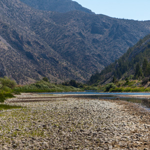
On 1 August 1805, Clark and the expedition’s flotilla of eight dugout canoes pushed up the Jefferson River through “a verrey high mountain which jutted its tremendious Clifts on either Side for 9 Miles, the rocks ragide.” They emerged into a “wide exte[n]sive vallie.”
The Tobacco Root Mountains
Beautiful prairies
by Joseph A. Mussulman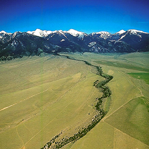
“We proceeded on and passed a large beautiful bottom,” wrote Pvt. Joseph Whitehouse on 2 August 1805, “and Prairies lying on both sides of the River.” On each side of the valley, Sergeant Gass observed, “there is a high range of mountains . . . with some spots of snow on their tops.”
The Beaverhead River
Home ground
by Joseph A. Mussulman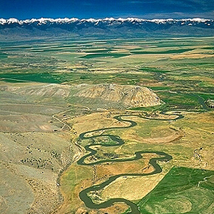
With what satisfaction and relief Lewis must have written, on 8 August 1805: “The Indian woman [Sacagawea] recognized the point of a high plain to our right which she informed us was not very distant from the summer retreat of her nation.”
Fortunate Camp
Western road
by Joseph A. Mussulman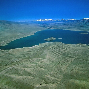
Today the confluence of the Beaverhead River and Horse Prairie Creek is submerged at left of the large island (photo center) in Clark Canyon reservoir, beneath eighty feet of water when the reservoir is full.
Across the Great Divide
Over Lemhi Pass
by Joseph A. Mussulman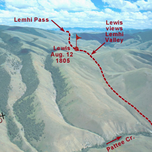
Below the summit of today’s Lemhi Pass, Lewis said that he had reached “the most distant fountain of the waters of the mighty Missouri in surch of which we have spent so many toilsome days and wristless nights.”
Lemhi Pass by Air
Division point
by Joseph A. Mussulman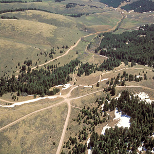
The gravel road winding parallels Trail Creek, which is lined by low willows. It corresponds roughly to the Indian road that Lewis, Drouillard, Shields, and McNeal followed westward from the forks of the Beaverhead River.
The Lemhi Valley
Hospitable people
by Joseph A. Mussulman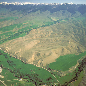
Lewis and his four companions crossed over the dividing ridge on the west side of the upper Missouri River basin and the Columbia drainage, then descended a dusty, well-traveled Indian road for some miles down into a “handsome little valley” among the sources of the Columbia River basin.
Meeting the Shoshones
by Joseph A. Mussulman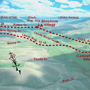
A few more Shoshones came in sight. Making all the benevolent signs and sounds he could think of, pondering ways to bring the wary Indians within talking distance, Lewis finally touched the hand of an elderly woman, and the spark of international friendship was struck.
The Shoshone Fish Weirs
by Joseph A. Mussulman, Steve F. Russell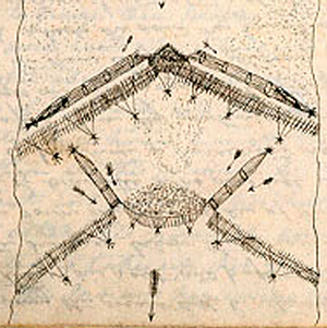
Clark visits a Shoshone camp on the west bank of the Lemhi River near today’s Salmon City, where he and his men are fed on “Sammon boiled, and dried Choke Cher[rie]s,” and taken on a sight-seeing trip to the nearby permanent fishing weirs.
The Salmon River
A river of no return
by Joseph A. Mussulman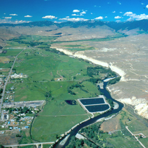
On the 23 August 1805, the centuries-old fantasy of a “water route across the continent for the purposes of commerce” dissolved in the roar of an unimaginable torrent–one of the most dangerous, unforgiving rivers in North America, that would later be called “The River of No Return.”
Leaving the Lemhi Valley
Detour at Tower Creek
by Joseph A. Mussulman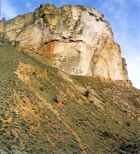
The Salmon winds tortuously through a seven-mile-long canyon where the vertical walls at that time crowded the riverbanks so tightly in several places that Clark and his party were compelled to clamber over “four mountains verry Steap high & rockey.”
The Lost Trail Divide
Leaving the Indian road
by Joseph A. Mussulman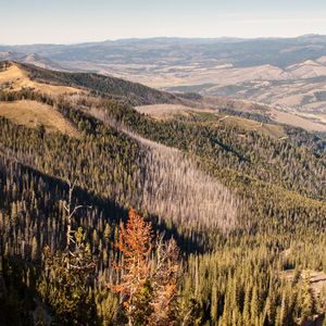
Continuing north up the North Fork Salmon River, they leave a good Indian road and must cut their own trail. Were they lost? Sergeant Gass’s laconic remark gives us a hint: “This was not the creek our guide wished to have come upon.”
Travelers’ Rest
Hub of the west
by Joseph A. Mussulman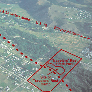
In the afternoon of 9 September 1805 they turned westward at a creek they dubbed Travelers’ Rest, today known as Lolo Creek. They stopped at a gathering place that Indians had been using for that same purpose for thousands of years.
Travelers’ Rest by Air
Turning point
by Joseph A. Mussulman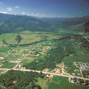
For three days the Corps rested here, gathering strength for the arduous 150-mile trek across the Bitterroot Mountains. The campsite was about two-thirds down in the photo, among the cottonwoods that shelter Lolo Creek.
Travelers’ Rest Creek
Today's Lolo Creek in Montana
by Joseph A. Mussulman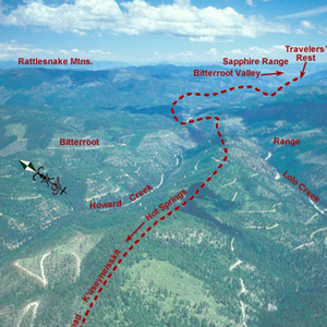
At 3 o’clock in the afternoon, 11 September 1805, Toby led the Corps of Discovery out of Travelers’ Rest camp toward the Bitterroot Mountain barrier.
Lolo Hot Springs
"beautiful to see"
by Joseph A. Mussulman
“These Springs are very beautiful to See, and we think them to be as good to bathe in &c. as any other ever yet found in the United States,” avowed Private Joe Whitehouse.
Packer Meadows
"A pretty little plain"
by Joseph A. Mussulman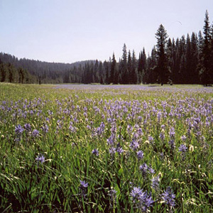
Lewis acknowledged it was “a pretty little plain of about 50 acres plentifully stocked with quawmash” and “one of the principal stages or encampments of the indians”
Climbing Wendover Ridge
Leaving the Lochsa
by Joseph A. Mussulman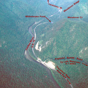
“Several horses Sliped and roled down Steep hills which hurt them verry much The one which Carried my desk & Small trunk Turned over & roled down a mountain for 40 yards & lodged against a tree, broke the Desk…”
The Bitterroots by Air
"Tremendious Mountanes"
by Joseph A. Mussulman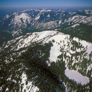
“I have been wet and as cold in every part as I ever was in my life,” Clark complained. “Indeed I was at one time fearfull my feet would freeze in the thin mockersons which I wore.”
Snowbank Camp to Lonesome Cove
Tough going
by Joseph A. Mussulman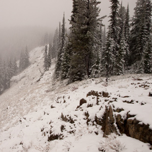
Although none of the journalists mentioned it, the very presence of last winter’s snow on those mountains in late September must have aroused the feeling that crossing the Rockies was going to be even tougher than they had figured.
A ‘Sinque’ Hole
Below the Smoking Place
by Joseph A. Mussulman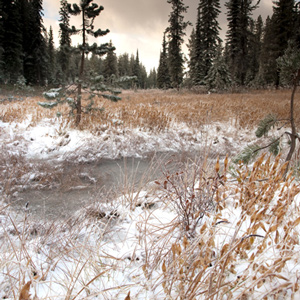
Private Whitehouse reported: “Camped at a Small branch on the mountain near a round deep Sinque hole full of water.”
Hungery Creek
And a return to Bald Mountain
by Joseph A. Mussulman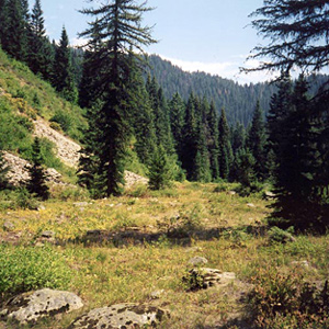
By the evening of 17 September 1805, their seventh sleep west of Travelers’ Rest, it was obvious to the captains that the Indians’ assurance that they could cross the mountains in six days was false, whereas the prediction that they would find no game there was all too true.
Weippe Prairie by Air
"Tryumph"
by Joseph A. Mussulman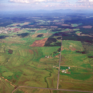
For countless generations, Weippe Prairie (prounouced WEE-yipe), like Travelers’ Rest, was a major node in the transportation, trade, and social networks of the Rocky Mountain West.
Eldorado Creek
Full Stomachs to Pheasant Camp
by Joseph A. Mussulman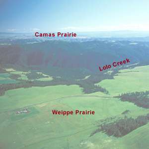
“we killed a few Pheasants, and I killd a prarie woolf [coyote] which together with the ballance of our horse beef and some crawfish which we obtained in the creek enabled us to make one more hearty meal.
Clearwater Canoe Camp by Air
by Joseph A. Mussulman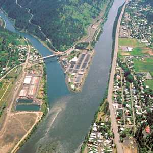
Still sick and exhausted from their recent crossing of the Bitterroot Mountains, Lewis, Clark, and their crew arrived on 26 September 1805, at what they called Canoe Camp, on the Clearwater River.
Colter’s Creek
Today's Potlatch River
by Joseph A. Mussulman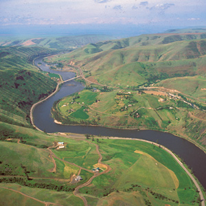
At 3 p.m. on 7 October 1805, the Corps loaded their five new dugout canoes–four large ones plus a small one “to look ahead”–and set out down the Clearwater River toward the Columbia and the Pacific beyond.
Meeting the Snake
Water color
by Joseph A. Mussulman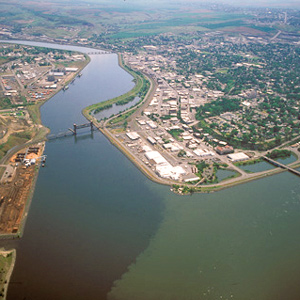
The Corps’ four-day trip to this point from Canoe Camp on the Clearwater in their five crowded dugouts was a taste of things to come.
Tucannon and Palouse Rivers
"rugid rocks"
by Joseph A. Mussulman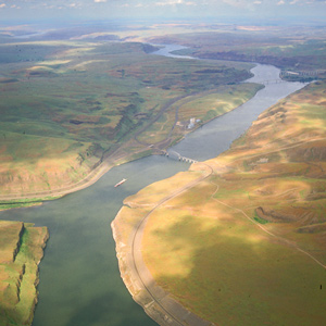
Now they entered a four-mile-long torrent, its climax a “narrows or narrow rapid” through which a channel 25 yards wide was confined between “rugid rocks” for a solid mile and a half.
Snake River Rapids
"Stuk fast"
by Joseph A. Mussulman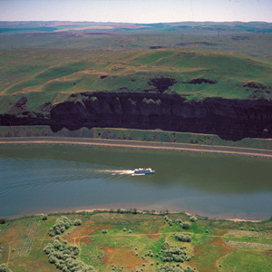
The boating didn’t improve on 14 October 1805. At the head of a particularly bad three-mile-long rapid, three canoes “Stuk fast for some time . . . and one Struk a rock in the worst part.”
Meeting the Columbia
A welcoming fanfare
by Joseph A. Mussulman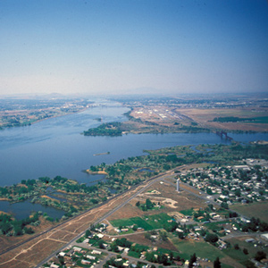
In the afternoon of 16 October 1805, the expedition portaged around “the last bad rapid as the Indians Sign to us”–the last on the Snake River, that is–and soon arrived at the “Great River of the West,” the Columbia.
Columbia River near Blalock
Greatest chief
by Joseph A. Mussulman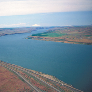
This scene’s most arresting feature is still the “high mountain of emence hight covered with Snow” on the photo’s horizon. Clark mistook it for Mount St. Helens. The Indians called the mountain Pahtoe. Since 1838 it has been known as Mount Adams.
Miller Island
River of the falls
by Joseph A. Mussulman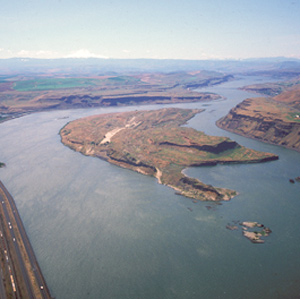
Near the west end of the island, they passed a sizeable tributary local Indians called To war ne hi ooks. The journalists left us no hint that the word they heard as Towarnehiooks was a Chinookan expression meaning “enemies.”
The Dalles
Through the Narrows
by Joseph A. Mussulman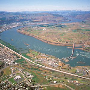
There really was no need for him to have been on the defensive. Pierre Cruzatte cast a spell over the assembled Indians with his fiddle, which was much more effective than any pompous diplomatic talk.
Beacon Rock by Air
Tidewater mark
by Joseph A. Mussulman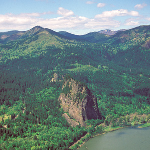
On 31 October 1805, Clark first saw this “remarkable high detached rock,” the eroded core of an ancient volcano, which he estimated stood eight hundred feet above the riverbank and was four hundred yards in circumference.
Columbia River Dams
The rough places plain
by Joseph A. Mussulman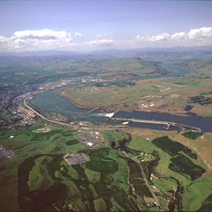
Bonneville Dam, was the first dam to be built on the Columbia River. The slackwater pool it impounds, called Lake Bonneville, eliminated the Cascades as a barrier to commercial shipping, and provided a deep, navigable channel for barges and tugs.
Ridgefield National Wildlife Refuge
Horrid noise
by Joseph A. Mussulman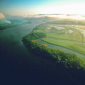
On the night of 4 November 1805 the expedition camped near a pond now called Post Office Lake. The next morning a weary, groggy Clark complained that he “could not Sleep for the noise” made by the numerous waterfowl.
The Columbia River Estuary
"Great joy"
by Joseph A. Mussulman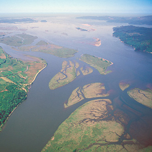
When the sky cleared briefly at about noon on 7 November 1805, a rising cheer may have startled the myriad waterfowl in the area, for Clark wrote, “we are in view of the opening of the Ocian, which Creates great joy.”
Point Ellice
"blustering point"
by Joseph A. Mussulman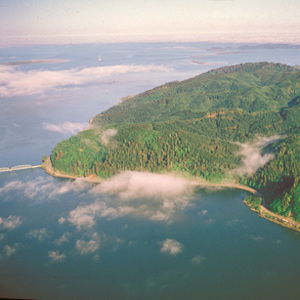
It was “the most disagreeable time I have experienced,” Clark grumbled on 15 November 1805. “Confined on a tempiest Coast wet, where I can neither get out to hunt, return to a better Situation, or proceed on”
Cape Disappointment
"This Emence Ocian"
by Joseph A. Mussulman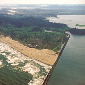
Private Whitehouse thought his captains had named Cape Disappointment “on account of not finding Vessells there,” but it had received the name years earlier.
Long Beach
Mementos
by Joseph A. Mussulman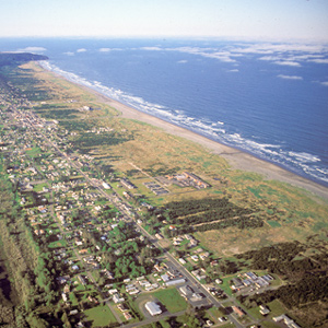
Clark’s party continued north along the beach for four miles, to the vicinity of today’s Long Beach, Washington. Here Clark memorialized their first visit to the Pacific Ocean by marking his name and the date on a small pine tree.
Experience the Lewis and Clark Trail
The Lewis and Clark Trail Experience—our sister site at lewisandclark.travel—connects the world to people and places on the Lewis and Clark Trail.
Discover More
- The Lewis and Clark Expedition: Day by Day by Gary E. Moulton (University of Nebraska Press, 2018). The story in prose, 14 May 1804–23 September 1806.
- The Lewis and Clark Journals: An American Epic of Discovery (abridged) by Gary E. Moulton (University of Nebraska Press, 2003). Selected journal excerpts, 14 May 1804–23 September 1806.
- The Lewis and Clark Journals. by Gary E. Moulton (University of Nebraska Press, 1983–2001). The complete story in 13 volumes.
This site is provided as a public service by the

Lewis and Clark Trail Alliance
with additional funding from the following: