Marias River Return
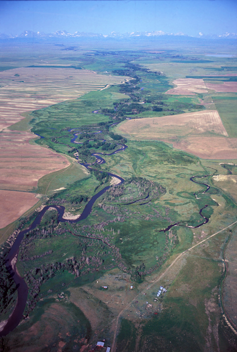
Cut Bank Creek, like the Two Medicine River, flows from the billion-year-old Precambrian Belt rocks, 2,000 feet thick, that comprise the mountains known since the 1890s as the Lewis Range. The mountains to right of center are in today’s Glacier National Park. The supposed site of Lewis’s camp on 22-25 July 1806, is on the left (south) side of the creek, left of center in the photo.
In 1806, with George Drouillard, Joe Field, and Reubin Field, Meriwether Lewis made a second excursion up the Marias, this time on horseback. The four men reached the northernmost point of the Expedition’s exploration on 22 July 1806, camping on the south side of today’s Cut Bank Creek about twelve miles northeast of present Browning, and six miles north of U.S. Highway 2. They had “arrived at a clump of large cottonwood trees in a beautifull and extensive bottom of the river about 10 miles below the foot of the rocky mountains where this river enters them.”
as I could see from hence very distinctly where the river entered the mountains and the bearing of this point being S of West I thought it unnecessary to proceed further.
Their camp was 232 river miles, or 152 parallel land miles, from the mouth of the Marias River. They were about 20 land miles from the point where Cut Bank Creek enters the mountains, and 44 river-miles from the ultimate source of the creek at Pitimaken Lake, 1,500 feet below the Continental Divide, in Glacier National Park.
Drouillard’s Route
From their camp on the north fork of the Marias River, now called Cut Bank Creek, Lewis dispatched George Drouilliard and Joseph Field to hunt. Reubin stayed with the captain.
I directed Drewyer who went up the river to observe it’s bearings and the point at which it entered the mountains, …this he did and on his return I observed the point at which the river entered to bear S 50 [degrees] W. distant about ten miles the river making a considerable bend to the West just above us.
That cinched it. The Marias did not originate north of the 50th parallel. Besides, neither hunter had any success, and provisions were low. They just managed to get by on one small trout, a few passenger pigeons, and a little mush of biscuitroot. “As if the fates were against me,” Lewis complained, his watch stopped. Nevertheless, he stayed where he was for two more days, hoping to make observations from which to determine the latitude and longitude of the place he was to dub “Camp Disappointment.”
Disappointing Observations
Marias River Country and the “Golden Triangle”
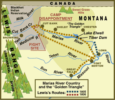
For more, see The Golden Triangle.
Camp Disappointment, Lewis knew, was another point that needed to have its whereabouts defined by its latitude and longitude. That, besides the opportunity to rest men and horses, was the reason he took the considerable risk that went with hanging around in Blackfeet Indian territory for three days. He hoped to find that Maria’s River had its sources north of the treaty boundary of Louisiana, which was 49 degrees, 37 minutes north latitude. That, if true, would mean that the Louisiana Purchase actually gave to the United States some land within the purported boundary of British ownership.
Cloudy skies prevented him from making all the celestial observations he needed, although he made one which, had he completed the calculations, would have told him he was camped at about 48 degrees, 41 minutes North latitude (a little over one mile north of the place we have deduced his camp actually was). One minute at that latitude is roughly equal to 1.15 miles, so he would have known that he was still about 91 miles south of his target.
Based on his estimate of the distance he had traveled north of the Missouri River, however, and the lay of the land around his camp, Lewis was reasonably sure of his approximate location.
And that—as disappointing as it was—was all he needed to know.
Tempting Fate
In the meantime, practical necessity required the identification of natural features that anyone could recognize on the ground. Meriwether Lewis was hoping that he could prove the headwaters of the Marias River would serve that purpose. On 22 July he and his companions camped on the south side of present Cut Bank Creek about 12 miles northeast of present Browning, Montana, and four miles north of U.S. Highway 2 (off today’s Meriwether Road), on the Blackfeet Indian Reservation. From his own calculations, and a reconnaissance by Drouillard, he concluded correctly that the Marias would not fill the bill.
Still, he thought it “more than probable” that the Milk River would. Ironically, he wasn’t aware that when he looked over the ridge a few miles north of camp and saw what he took to be the Saskatchewan River, he was actually looking at the Milk, which rises just a few miles north of the headwaters of Cut Bank Creek, flows northward into Canada, then turns southeast to join the Missouri River near present Fort Peck Dam. For three days Lewis tried making the necessary astronomical observations to determine the latitude of his camp, but inclement weather prevented him from completing them. Today, if we have guessed correctly where his camp was, we can say it was at 48 degrees, 39 minutes north latitude.
Although the grazing was good for their horses, food for the men was scant for the first two days, until Drouilliard brought in a buck deer late on the third. In the meantime they got by on passenger-pigeon meat, with some mush made of cous roots they had brought with them. They caught but one small trout in the creek, not realizing they had camped near a blue heron rookery, which kept the fish population low.[1]Wilbur Werner, ” . . . one small trout,” We Proceeded On, Vol. 13, No. 4.
On the 25th Lewis lamented that “as if the fates were against me my chronometer from some unknown cause stoped today.” On the 26th they awakened to “rain as usual.” At 9:00 a.m., Lewis wrote, “we set out biding a lasting adieu to this place which I now call camp disappointment.”
During their hunting and exploring jaunts they found evidence that Indians had recently camped in the vicinity. In that regard, “the fates” had more to reveal. The very next day they would encounter eight Peigan Indians, sup and parley with them cordially, and waken the next morning to a hand-to-hand conflict that would become the darkest blemish on the Expedition’s record.
Further Reading
Dava Sobel, Longitude: The True Story of a Lone Genius Who Solved the Greatest Scientific Problem of His Time (New York: Walker and Company, 1995).
Robert E. Lange, “Meriwether Lewis’s ‘Camp Disappointment’,” We Proceeded On, Vol. 3, No. 1.


Camp Disappointment is a High Potential Historic Site along the Lewis and Clark National Historic Trail managed by the U.S. National Park Service. The site is on private property within the Blackfeet Indian Reservation—ed.
Notes
| ↑1 | Wilbur Werner, ” . . . one small trout,” We Proceeded On, Vol. 13, No. 4. |
|---|
Experience the Lewis and Clark Trail
The Lewis and Clark Trail Experience—our sister site at lewisandclark.travel—connects the world to people and places on the Lewis and Clark Trail.
![]()
Discover More
- The Lewis and Clark Expedition: Day by Day by Gary E. Moulton (University of Nebraska Press, 2018). The story in prose, 14 May 1804–23 September 1806.
- The Lewis and Clark Journals: An American Epic of Discovery (abridged) by Gary E. Moulton (University of Nebraska Press, 2003). Selected journal excerpts, 14 May 1804–23 September 1806.
- The Lewis and Clark Journals. by Gary E. Moulton (University of Nebraska Press, 1983–2001). The complete story in 13 volumes.
This site is provided as a public service by the
![]()
Lewis and Clark Trail Alliance
with additional funding from the following:

