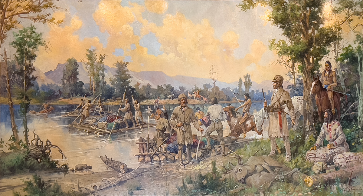
“Lewis Party Crossing the Clark Fork, July 3, 1806”
by Edgar S. Paxson (1914)
Oil on linen, 5½’ by 10′, commissioned for the Missoula County Courthouse, Missoula County Art Collection, Missoula Art Museum. © 2023 by Kristopher K. Townsend. Permission to use granted under the Creative Commons Attribution-Share Alike 4.0 International license.
Leaving Travelers’ Rest
At Travelers’ Rest on the morning of 3 July 1806, the captains divided the Corps of Discovery into two detachments. Clark would command the larger one, heading back to Fortunate Camp, then downriver to the Three Forks of the Missouri, there to divide again, with Ordway and a small detail taking the canoes down to White Bear Islands, and Clark leading the rest down the Yellowstone, to rendezvous with Lewis’s contingent about the first of August.
George Drouillard, Sergeant Patrick Gass, and Privates Joseph and Reubin Field, Robert Frazer, Silas Goodrich, Hugh McNeal, John Thompson, and William Werner went with Lewis. Their outfit numbered 17 horses plus five Nez Perce guides and their mounts. And Lewis’s dog, Seaman, of course. Their immediate mission was to explore the shortcut between Travelers’ Rest and the Great Falls of the Missouri that the Mandan Chief Sheheke, had first told the captains about in the winter of 1805, and their Lemhi Shoshone guide Toby had mentioned the following September:
as we had no other means of passing the river we busied ourselves collecting dry timber for the purpose of constructing rafts; timber being scarce we found considerable difficulty in procuring as much as made three small rafts. we arrived at 11 A. M. and had our rafts completed by 3 P. M. when we dined and began to take over our baggage which we effected in the course of 3 hours the rafts being obliged to return several times. the Indians swam over their horses and drew over their baggage in little basons of deer skins which they constructed in a very few minutes for that purpose.
Paxton’s Rendition
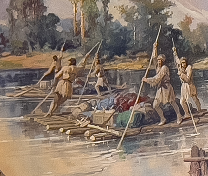
Edgar Paxson Knew Rivers [Detail]
© 2023 by Kristopher K. Townsend. Permission to use granted under the Creative Commons Attribution-Share Alike 4.0 International license.
The postures of the three men poling the nearer raft reflect the difficulty of propelling the unwieldy watercraft, and the teamwork required to keep it under control in the river’s continually shifting dynamics. The two men at right are on the side closer to the shore, where the current is relatively slow. The man at the corner of the raft, with his left elbow close to his body and his inner right thigh supporting his pole for leverage, is pushing across the current with a short strong stroke. The man ahead of him, with both arms extended, is trying to counteract the force of the current, which is sweeping the raft downstream at between three and four miles per hour—the speed of a fast walk. The third man is evidently near the main channel where the river focuses its maximum velocity. He is leaning his whole weight into his pole to keep the raft from being spun around by the current.
Those three X-shaped objects among the nondescript baggage on the raft are typical of sawbuck pack saddles.
Edgar S. Paxson shows Lewis, his nine-man detachment, and their Nez Perce guides starting across the Clark Fork River two miles below its confluence with the Bitterroot, and nearly opposite the site of Missoula. For the sake of the drama inherent in the events of 3 and 4 July 1806, Paxson has rearranged the documented sequence of events. The clouds in the northeast sky are tinged with the colors of approaching sunset, by which time all the men actually had finished crossing the river.
A few of Lewis’s men are loading the third raft on the south bank, while others are pushing the first two rafts toward the north shore. Here, where the Indians had recommended they cross, it was “rapid and 150 yds. wide.” With every crossing they unavoidably drifted farther downstream. Lewis recounted the climactic episode of the day:
I remained myself with two men who could scarcely swim untill the last; by this time the raft by passing so frequently had fallen a considerable distance down the river to a rapid and difficult part of it crouded with several small Islands and willow bars which were not overflown; with these men I set out on the raft and was soon hurried down with the current a mile and a half before we made shore, on our approach to the shore the raft sunk and I was drawn off the raft by a bush and swam on shore the two men remained on the raft and fortunately effected a landing at some little distance below. I wet the chronometer by this accedent which I had placed in my fob as I conceived for greater security.
Meanwhile the Indians, Lewis explained, “swam over their horses and drew over their baggage in little basons of deer skins which they constructed in a very few minutes for that purpose.” The five Nez Perce men who guided the Corps back across the Bitterroots and had intended to accompany them to the Falls of the Missouri are seen on the near and far shores and in the water. Paxson compressed time in this scene by including a sixth Indian who had pursued the Corps across the mountains and caught up with Lewis on 4 July at the camp on Grant Creek. That morning all six Nez Perce, perhaps having decided Lewis’s contingent was too small for adequate defense against hostile Blackfeet Indians, assured them the road would be easy to follow from there on, and turned back.
Lewis complained that timber was so scarce they could barely find enough to build three small rafts, probably binding the logs and crosspieces together with strips of willow bark. It is therefore unlikely that they looked anything like the large and well-pegged structures Paxson imagined. Yet verisimilitude is not necessarily a criterion in art—even in historical art. Too much truth can spoil the story.
Nez Perce Arrival and Departure
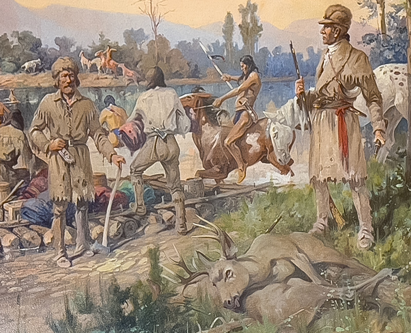
Lewis Issues an Order [Detail]
© 2023 by Kristopher K. Townsend. Permission to use granted under the Creative Commons Attribution-Share Alike 4.0 International license.
Captain Lewis, wearing the red sash that indicates his rank, and with his partially collapsed spyglass in his left hand, is ordering one of his men to give the Indians some of the meat from the mule deer the hunters have shot. Journal entries by both Lewis and Gass indicate the hunters shot three deer after the crossing was complete. Furthermore, in reality the hunters would have field-dressed them where they fell, to avoid attracting scavengers and vermin into their camp. But Paxson has discreetly chosen not to offend his more sensitive viewers.
The Indian on horseback at extreme right may be the one who showed up at 6:00 a.m.—actually the next morning, July 4—who had followed the Corps across the Bitterroots, hoping to join them on their trip to the Falls of the Missouri:
he proved to be the same young man who had first attempted to pass the rocky mountains early in June last when we lay on the Kooskooske and was obliged to relinquish the enterprize in consequence of the debth and softness of the snow.
The figure facing us at left may have been meant to represent Sergeant Patrick Gass, although he closely resembles George Drouillard in the other mural. Here, Drouillard may be the man seated at lower right, his decorated shirt suggesting his Shawnee Indian mother’s heritage. Behind Lewis is the “excellent horse” one of the Nez Perce guides had given Lewis on 26 June 1806, “for the good council we had given himself and nation and also to assure us of his attachment to the white men.”[1]Lewis mentioned these details on 1 July 1806. Back on 13 May 1806, two Nez Perce youths had presented Lewis with “a most elligant mare.”
On the morning of the fourth all six Nez Perce men announced their decision to turn back, pay a visit to some Salish friends downriver, then head home the way they came. While betraying “every emmotion of unfeigned regret at seperating from us,” those “affectionate people,” perhaps fearing that Lewis’s little detachment would be no match for the Blackfeet and other Pahkees—Shoshone for “enemies,” including Arapahoes, Atsinas, and Assiniboines—warned the Americans that they were doomed. Lewis, undaunted, reassured himself with his new discovery:
it is worthy of remark that these people were about to return by the same pass by which they had conducted us through the difficult part of the Rocky Mountains. . . . a circumstance which to my mind furnishes sufficient evidence that there is not so near or so good a rout to the plains of Columbia by land along that river as that which we came. . . . all the nations also on the west side of the mountain with whom we are acquainted inhabiting the waters of Lewis’s river & who visit the plains of the Missouri pass by this rout.[2]Upon arrival at Travelers’ Rest in September 1805, Lewis had considered following Clark’s River to the Columbia, but dismissed the idea because Toby couldn’t vouch for it as a … Continue reading
Somehow, perhaps combining what he had learned about the geography of the Rockies from Sheheke back at Fort Mandan two winters before, he also concluded that “the several war routs of the Minetarees which fall into this vally of Clark’s river concenter at traveller’s rest beyond which point they have never yet dared to venture in pursuit of the nations beyond the mountains.”
Artist Edgar Paxson introduced imaginary mountain ridges on the horizons in both murals, suggesting the craggy peaks of the Bitterroot Range some miles to the south of these locations rather than the low, smooth slopes actually seen from water level near the place where Lewis crossed, and at Travelers’ Rest. His purpose, no doubt, was to suggest the grandeur of the wilderness setting in which all these fleeting human dramas took place.
History Repeated
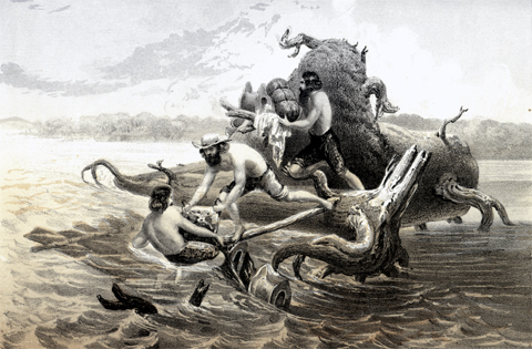
By Gustavus Sohon (1825–1903)
The next official government expedition to cross the Clark Fork River near Missoula had an experience similar to Lewis’s on 5 May 1854, as illustrated by Gustavus Sohon, one of two artists who accompanied Isaac Stevens’s Railroad Survey. The three victims are struggling to get their baggage to the relative safety of the huge root-wad of a tree on which their raft has been swamped. The objects that resemble hats may be riding saddles, although there is no accounting for the unusual design. The forked black objects at lower left that look like legs are limbs of another partially submerged snag.[3]Isaac I. Stevens, Governor of Washington Territory, Narrative and Final Report of Explorations for a Route for a Pacific Railroad near the Forth-seventh and Forty-ninth Parallels of North Latitude, … Continue reading
Notes
| ↑1 | Lewis mentioned these details on 1 July 1806. |
|---|---|
| ↑2 | Upon arrival at Travelers’ Rest in September 1805, Lewis had considered following Clark’s River to the Columbia, but dismissed the idea because Toby couldn’t vouch for it as a practical route, but mainly because he surmised that a major waterfall somewhere downriver explained the absence of salmon thereabouts. Had the captains decided to proceed by that route, it would have taken them twice as long to reach the Pacific Ocean as it did by following the Indian road across the Bitterroot Mountains. |
| ↑3 | Isaac I. Stevens, Governor of Washington Territory, Narrative and Final Report of Explorations for a Route for a Pacific Railroad near the Forth-seventh and Forty-ninth Parallels of North Latitude, from St. Paul to Puget Sound (12 vols, Washington, D.C., 1855), Vol. 11, Book 1, Plate 65. |
Experience the Lewis and Clark Trail
The Lewis and Clark Trail Experience—our sister site at lewisandclark.travel—connects the world to people and places on the Lewis and Clark Trail.
Discover More
- The Lewis and Clark Expedition: Day by Day by Gary E. Moulton (University of Nebraska Press, 2018). The story in prose, 14 May 1804–23 September 1806.
- The Lewis and Clark Journals: An American Epic of Discovery (abridged) by Gary E. Moulton (University of Nebraska Press, 2003). Selected journal excerpts, 14 May 1804–23 September 1806.
- The Lewis and Clark Journals. by Gary E. Moulton (University of Nebraska Press, 1983–2001). The complete story in 13 volumes.


