A day or two after Christmas, 25 December 1805, the captains were informed by some Indians that a whale had died on the beach near a Tillamook village southwest of the fort. Captain Lewis was eager to go and see it, but high wind delayed his trip. On 3 January 1806 some Clatsop Indians brought foodstuffs to sell to the Americans: “some roots buries and three dogs also a small quantity of fresh blubber.” It was finally Clark who, on 6 January 1806, left with 12 men in two canoes out of Youngs Bay and up the comparatively placid Skipanon River,[1]Charbonneau and Sacagawea—presumably carrying baby Jean Baptiste Charbonneau—also went along. “The Indian woman was very importunate to be permitted to go,” wrote Lewis, “and … Continue reading then by land to the saltmakers’ camp, and over Tillamook Head.
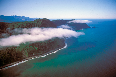
Clark’s Point of View
Tillamook Head and “Clark’s Point of View”
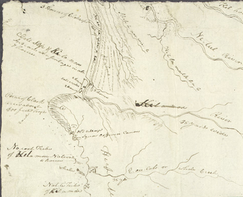
To see labels, point to the image.
Yale Collection of Western Americana, Beinecke Rare Book and Manuscript Library. Full size, 10-3/4″ by 5-7/8″.
“Point of Clark view about 800 feet high”: In the “Fort Clatsop Miscellany” (Moulton, Vol. 6, p. 460), the journalist has noted: “the most projicted part of the Mountain of Clarks point of view of 1000 feet above the leavel of the water.” The highest point on Tillamook Head is exactly 1136 feet above mean sea level.
On his side trip to Cape Disappointment from Station Camp in November 1805, William Clark observed “a high point of a Mountn.” about 30 miles to the southwest. Later, Lewis took the liberty of naming it “Clark’s Mountain and point of view.” Eventually it was to be called Tillamook Head, after the Indians who lived nearby, who themselves called it Nah-se-u’-su.
On 7 January 1806, after passing the salt works and continuing along the “round Slippery Stones under a high hill,” Clark related, “my guide made a Sudin halt, pointed to the top of the mountain and uttered the word Pe Shack which means bad, and made Signs that we . . . must pass over that mountain. I hesitated a moment & view this emence mountain the top of which was obscured in the clouds and the assent appeared to be almost perpindecular.”
After two hours of “labour and fatigue,” at one point drawing themselves up by bushes and roots, they reached the summit of Bald Mountain. As they climbed over the 1,136-foot headland, Clark paused at a scenic viewpoint some 650 precipitous feet above the surf:
from this point I beheld the grandest and most pleasing prospects which my eyes ever surveyed, in my frount a boundless Ocean; . . . the Seas rageing with emence wave and brakeing with great force from the rocks of Cape Disappointment as far as I coud See to the N. W. . . . the nitches and points of high land which forms this Corse for a long ways aded to the inoumerable rocks of emence Sise out at a great distance from the Shore and against which the Seas brak with great force gives this Coast a most romantic appearance.
Clark’s Point of View
360° Panorama View
Photography by Allan McMakin.
This panorama was photographed from the promontory on which Clark may have stood. Called Bird Point today, it has eroded considerably since then by wind and rain. Indeed, Clark noted that even at that time the headland was “slipping from the Sides of the high hills, in emence masses; fifty or a hundred acres at a time give way and a great proportion of an instant precipitated into the Ocean.”
Just out of sight to the south (left) in the panorama is Ecola Creek, where the whale’s remains were. In 1846 the schooner Shark sank nearby, and a portion of her deck bearing a small cannon washed ashore in that vicinity. The community of Cannon Beach, now a resort center, began in 1891. A short distance offshore is 235-foot Haystack Rock, also out of the camera’s view.
The larger of the two rocks in the ocean at northwest by north is Tillamook Rock, on which a lighthouse stood from 1880 until 1957. In 1980 the lighthouse was turned into a columbarium—a repository for the ashes of cremated bodies.
Just north of the Head, out of view, was the Clatsop Indian village called Ne-co-tat, near the mouth of the Necanicum River where the Corps’ saltmaking contingent set up their camp and stone oven. In the early 1870s a hotel and resort called Seaside House was built there. During the first half of the 20th century the Spokane, Portland and Seattle Railway brought vacationers from Portland and points east.
The mouth of the Columbia River is northward beyond the point of Tillamook Head.
Further Reading
Glen Kirkpatrick, “The Rediscovery of Clark’s Point of View,” We Proceeded On, Vol. 25, No. 1 (February 1999), 28-31.
Ecola Creek / Cannon Beach is a High Potential Historic Site along the Lewis and Clark National Historic Trail managed by the U.S. National Park Service. “North of Ecola Creek is Les Shirley Park, with restored wetlands and interpretive wayside exhibits commemorating the Corps of Discovery. South of Ecola Creek is Ne Cus’ Park, encompassing the Ecola Creek Village archeological site.”—ed.
Notes
| ↑1 | Charbonneau and Sacagawea—presumably carrying baby Jean Baptiste Charbonneau—also went along. “The Indian woman was very importunate to be permitted to go,” wrote Lewis, “and was therefore indulged; she observed that she had traveled a long way with us to see the great waters, and that now that monstrous fish was also to be seen, she thought it very hard she could not be premitted to see either (she had never yet been to the Ocean).” |
|---|
Experience the Lewis and Clark Trail
The Lewis and Clark Trail Experience—our sister site at lewisandclark.travel—connects the world to people and places on the Lewis and Clark Trail.
Discover More
- The Lewis and Clark Expedition: Day by Day by Gary E. Moulton (University of Nebraska Press, 2018). The story in prose, 14 May 1804–23 September 1806.
- The Lewis and Clark Journals: An American Epic of Discovery (abridged) by Gary E. Moulton (University of Nebraska Press, 2003). Selected journal excerpts, 14 May 1804–23 September 1806.
- The Lewis and Clark Journals. by Gary E. Moulton (University of Nebraska Press, 1983–2001). The complete story in 13 volumes.


