On the Marias River, Lewis can see the divide between the Marias and South Saskatchewan, and his hopes for extending the boundaries of the Louisiana Territory dim.
On the Yellowstone River, Clark has the men start two new dugout canoes. He rests his horses before they are sent to the Knife River Indian Villages with hopes that Hugh Heney will accept a commission.
Above the Great Falls of the Missouri, Sgt. Ordway‘s squad rests having paddled the past several days. Sgt. Gass‘s squad makes final preparations for portaging the dugouts.
A Little Geology Lesson
by Yellowstone Public Radio[1]Originally aired weekdays by Yellowstone Public Radio during the Bicentennial observance of 2003-2006. Narrated by Hal Hansen. Scripts by Whit Hansen and Ed Jacobson. Produced by Leni Holliman. © … Continue reading
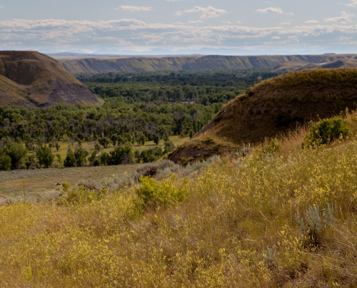
Marias River Bottom
South of Shelby, Montana, 21 July 2011. © Kristopher K. Townsend. Permission to use granted under the Creative Commons Attribution-Share Alike 4.0 International license.
Lewis’s Hopes Dim
Bluffs and Bottoms
the bluffs of the river are about 200 feet high, steep irregular and formed of earth which readily desolves with water, slips and precipitates itself into the river . . . . the soil of the river bottom is fertile and well timbered
—Meriwether Lewis
Fewer Buffalo, More Elk
we have seen fewer buffaloe today than usual, though more Elk and not less wolves and Antelopes [pronghorns] also some mule deer; this speceis of deer seems most prevalent in this quarter.
—Meriwether Lewis
Marias River Hopes Dim
from the apparent decent of the country to the North and above the broken mountains I am induced to beleive that the South branch of the Suskashawan receives a part of it’s waters from the plain even to the borders of this river
—Meriwether Lewis
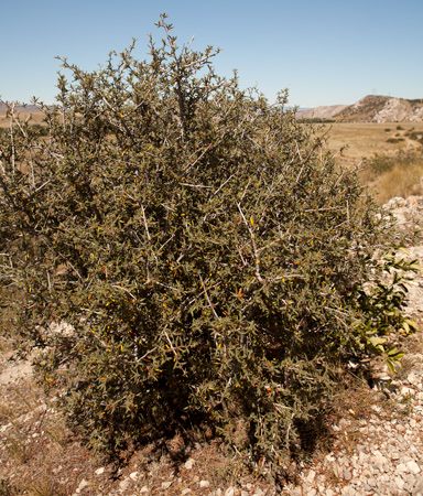
Greasewood
Sarcobatus vermiculatus
Missouri River Headwaters, 23 July 2013. © Kristopher K. Townsend. Permission to use granted under the Creative Commons Attribution-Share Alike 4.0 International license.
Greasewood Specimen
A Small branchy Shrub from the plains of Missouri—July 20th 1806.
—Meriwether Lewis[2]Sarcobatus vermiculatus. Moulton, ed. Herbarium, specimen 157.
Weather Diary (Lewis)
State of the weather at rise
Wind at rise
State of the weather at 4 P. M. Wind at 4 P. M. fair E fair N. —Meriwether Lewis
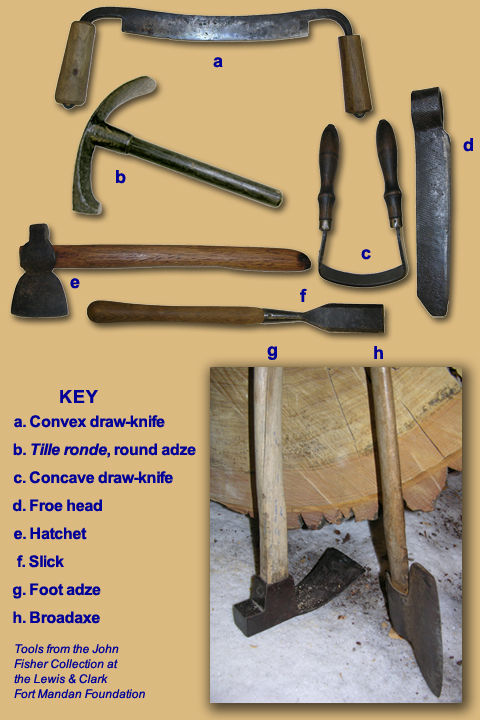
Canoe-carving Tools
Tools from the John W. Fisher Collection at the Lewis & Clark Fort Mandan Foundation
a. Convex draw-knife: Shaping blades of paddles
b. Tille ronde, round adze: Finishing inside of canoe hull
c. Concave draw-knife: Shaping throat, shaft and grip of canoe paddles
d. Froe head: Splitting planks for thwarts
e. Hatchet: Single-beveled hatchet for intermediate finishing of hulls
f. Slick: Removing bark from logs
g. Foot adze: Initial hollowing-out of hulls
h. Broadaxe: Single-beveled broadaxe for smoothing of outer hulls
Clark Starts Two Canoes
Wolves Ruin Labiche’s Elk
I also Sent Labech [Labiche] Shabono [Charbonneau] & hall [Hugh Hall] to Skin & some of the flesh of the Elk Labeech had killed last evening they returned with one Skin the wolves haveing eaten the most of the other four Elk.
—William Clark
Preparing Axes
I also Sent two men in Serch of wood Soutable for ax handles. they found some choke cherry which is the best wood which Can be precured in this Country.
—William Clark
Starting Two Canoes
had handles put in the 3 Axes and after Sharpening them with a file fell the two trees which I intended for the two Canoes. those trees appeared tolerably Sound and will make Canoes of 28 feet in length and about 16 or 18 inches deep and from 16 to 24 inches wide.
—William Clark
Resting Horses
The horses being fatigued and their feet very Sore, I Shall let them rest a fiew days. dureing which time the party intended for to take them by land to the Mandans will dress their Skins and make themselves Clothes to bare, as they are nearly naked.
—William Clark
Good Hunting
Shields killed a Deer & Buffalow & Shannon a faun and a Buffalow & York an Elk one of the buffalow was good meat. I had the best of him brought in and cut thin and Spread out to dry.
—William Clark
Weather Diary (Clark)
State of the weather at Sun rise Wind at Sun rise State of the weather at 4 P. M Wind at 4 P M. fair N E fair N E Sworms of grass hoppers have eaten the grass of the plains for many miles. The River Rochejhone [Yellowstone] falls about ½ an in in 24 hours and becoms much Clearer than above. The Grass hoppers are emencely noumerous and have distroyed every Species of grass from one to 10 Miles above on the river & a great distance back.
—William Clark[3]To assist the reader of this web page, the date column is omitted and some abbreviations have been spelled out.
Gass and Ordway Prepare Wagons
we conclude to lay here to day as the truck waggons are not fixed. Sergt. Gass went at putting in the tongues to the waggons. Some of the men are engaged dressing Skins . . . . towards evening we got up our 4 horses tackled them in the truck waggons found they would draw but were covred thick with Musquetoes and Small flyes &C.
—John Ordway
Hugh Heney’s Commission
This letter was from a draft written before dividing forces at Travelers Rest. Entirely in Clark’s hand, it is possible that only the location and date were while at the Yellowstone canoe camp.
Camp on the River Rochejhone East of the Rocky
Mountains July 20th 1806—a CopySir [Hugh Heney]
. . . . .
At present we have a commission to charge you with, which if executed, we have no doubt will tend to advance your private interest, while it will also promote those of the U. States in relation to the intercourse of her citizens with the Indian nations of the interior of North America. It is provailing on some of the most influensial Chiefs of those bands of Sioux who usially resort the borders of the Missouri to visit the Seat of Government, and to accompany them there yourself with us.
. . . . .
W. Clark Capt. &c.[4]Letters of the Lewis and Clark Expedition with Related Documents: 1783–1854, 2nd ed., ed. Donald Jackson (Urbana: University of Illinois Press, 1978), 309, 313.
Experience the Lewis and Clark Trail
The Lewis and Clark Trail Experience—our sister site at lewisandclark.travel—connects the world to people and places on the Lewis and Clark Trail.
Plan a trip related to July 20, 1806:
- Marias Museum of History and Art (Lewis)
- Billings, Montana (Clark)
- Three Forks to Billings Driving Tour (Clark)
- Lewis and Clark National Historic Trail Interpretive Center (Gass and Ordway)

Clark’s Canoe Camp on the Yellowstone is a High Potential Historic Site along the Lewis and Clark National Historic Trail managed by the U.S. National Park Service. The site is on private property.
The Great Falls Portage is a High Potential Historic Site along the Lewis and Clark National Historic Trail managed by the U.S. National Park Service. It includes Sulphur Springs (open to the public) and Lower Portage Camp site (private land), and the Upper Portage Camp Overlook.
Notes
| ↑1 | Originally aired weekdays by Yellowstone Public Radio during the Bicentennial observance of 2003-2006. Narrated by Hal Hansen. Scripts by Whit Hansen and Ed Jacobson. Produced by Leni Holliman. © 2003 by Yellowstone Public Radio. |
|---|---|
| ↑2 | Sarcobatus vermiculatus. Moulton, ed. Herbarium, specimen 157. |
| ↑3 | To assist the reader of this web page, the date column is omitted and some abbreviations have been spelled out. |
| ↑4 | Letters of the Lewis and Clark Expedition with Related Documents: 1783–1854, 2nd ed., ed. Donald Jackson (Urbana: University of Illinois Press, 1978), 309, 313. |


