© Michael Haynes, https://www.mhaynesart.com. Used with permission.
On 12 June 1805, Lewis leaves Decision Point at the mouth of the Marias to find the Great Falls of the Missouri. He finds them “truly magnifficent and sublimely grand”.
After traveling separate routes from Decision Point, Clark and Lewis reunite at what would become known as Lower Portage Camp. Clark leaves to survey a portage route, and Lewis attends to Sacagawea whose condition has become “Somewhat dangerous”.
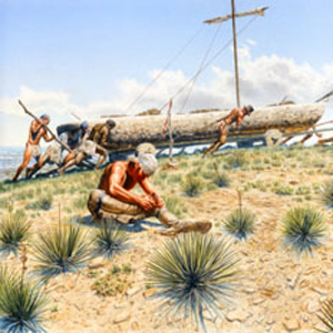
Wheels and trucks are built from cottonwood trees, and the dugouts are hauled two miles up Belt Creek. Lewis leads the first canoe overland to the White Bear Islands where he focuses on construction of the iron-framed boat.
Several trips are needed—as are several truck repairs—to get all the canoes and baggage to the upper portage camp. While site seeing during the last stage, Clark, Sacagawea, and Jean Baptiste are nearly swept away in a flash flood.
Celebrating the Fourth of July, they drink the last of whiskey. Then, due to a lack of pitch pine in the area, the cover of the iron-framed boat leaks too much water to be of practical use and is cached.
Clark moves a few miles up the river and his crew builds two more canoes so that they can continue up the Missouri.
The Blackfeet
by Kristopher K. Townsend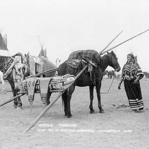
They commonly called themselves saokí•tap•ksi meaning ‘prairie people.’ The meaning ‘people with black feet’ comes from exonymns—the names given by other, external tribes. Historically, several related groups comprise the Blackfoot or Blackfeet people.
The Iron-framed Boat
"the Experiment"
by Mark W. Jordan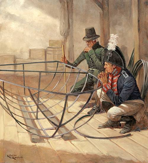
The explorers assembled the iron-framed boat in the early summer of 1805 at the Upper Portage Camp, upstream of the Great Falls. There Lewis and the men put together the frame. “We called her the Experiment,” wrote Sergeant Patrick Gass.
Synopsis Part 3
The Marias River to the Lemhi Valley
by Harry W. Fritz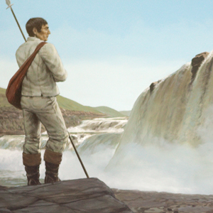
The captains were worried. The expedition was quickly running out of time and space: time to cross the Rockies before winter, and space to find the Shoshones, with their horses and guides. Another month of increasingly toilsome river travel would ensue.
Lewis’s Three Wishes
Pencil, pen, and camera obscura
by Joseph A. Mussulman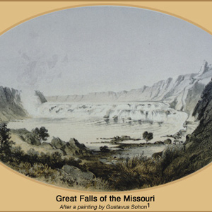
“I wished for the pencil of Salvator Rosa, or the pen of Thompson, that I might be enabled to give to the enlightened world some just idea of this truly magnifficent and sublimely grand object, which has from the commencement of time been concealed from the view of civilized man”
The Falls of the Missouri
by Joseph A. Mussulman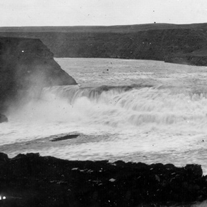
From Indian information the previous winter, the captains knew they would encounter a great falls in the Missouri River. What they found was a 14-mile-long series of waterfalls and rapids that drops 473 feet.
The Sun River by Air
"Curious adventures"
by Joseph A. Mussulman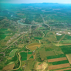
The day’s “succession of curious adventures wore the impression on my mind of inchantment,” he mused. “It now seemed to me that all the beasts of the neighbourhood had made a league to distroy me.”
Mapping the Falls
by Joseph A. Mussulman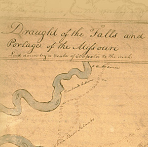
The falls of the Missouri comprised the most remarkable of all the “remarkeable points” that Clark described and mapped in conscientious obedience to an order from Thomas Jefferson to take observations “with great pains & accuracy.”
Lower Portage Camp
Good news, bad news
by Joseph A. Mussulman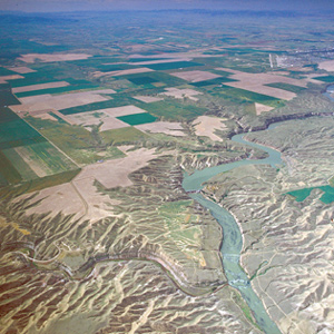
By the evening of 15 June 1805, Clark had gotten the canoes and the white perogue as close to the Great Falls as possible, and the next afternoon Lewis joined him at the “lower portage camp,” a mile below the mouth of Belt Creek.
Sulphur Springs
A cure for Sacagawea?
by David J. Peck, Joseph A. Mussulman
On his return to the mouth of the Marias, Lewis found Sacagawea gravely ill. He had his men cross the river “to procure the water of the Sulpher spring,” “the virtues of which,” Lewis asserted, “I now resolved to try on the Indian woman.”
Clark’s Portage Route Survey
Measuring the falls and portage
by Joseph A. Mussulman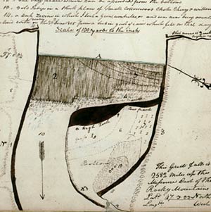
On 17 June 1805, Clark and five men set out to determine the best portage route around the Great Falls of the Missouri. On the way up the river, he stopped to also measure the fall of the river and to map the falls.
Giant Springs
by Joseph A. Mussulman, William O'Keefe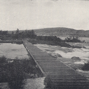
Clark and his five men “proceeded on up the river a little more than a mile to the largest fountain or Spring I ever Saw, and doubt if it is not the largest in American Known.”
The Portage Route
Around the Falls of the Missouri
by Joseph A. Mussulman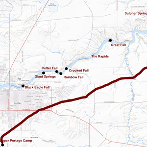
The shuttling of all the baggage and six canoes across the prairie to the upper portage camp opposite White Bear Islands began on 21 June 1805 and was completed on 2 July 1805. All in all, it was one of the most grueling undertakings on the entire expedition.
A Flash Flood
A narrow escape
by Joseph A. Mussulman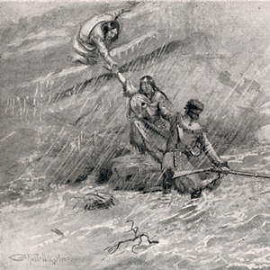
Of all the near-calamities the Corps of Discovery experienced, none was more dire than the one that occurred on 29 June 1805 in a normally dry ravine a short distance above the Great Fall. The principals were Charbonneau, Sacagawea, Jean Baptiste, York, and William Clark.
Unaccountable ‘Artillery’ of the Rockies
by Joseph A. Mussulman
Near the Great Falls, Lewis describes loud noises “resembling precisely the discharge of a piece of ordinance of 6 pounds at the distance of three miles.” Thunder didn’t seem likely as “It was perfectly calm, clear, and not a cloud to be seen.”
Square Butte
Lewis's Fort Mountain
by Joseph A. Mussulman
“This mountain has a singular appearance. it is situated in a level plain, it’s sides stand nearly at right angles with each other and are each about a mile in extent … from it’s figure we gave it the name of fort mountain.”
Illustrating the Great Fall
At the Falls of the Missouri
by Joseph A. Mussulman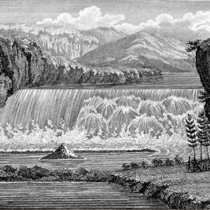
After Lewis’s preliminary sketch, later artists and photographers contributed to the visual documentation of the “sublimely grand” waterfall including Barralet, Gustavus Sohon, A. E. Mathews, and F. Jay Haynes.
Experience the Lewis and Clark Trail
The Lewis and Clark Trail Experience—our sister site at lewisandclark.travel—connects the world to people and places on the Lewis and Clark Trail.
![]()
Discover More
- The Lewis and Clark Expedition: Day by Day by Gary E. Moulton (University of Nebraska Press, 2018). The story in prose, 14 May 1804–23 September 1806.
- The Lewis and Clark Journals: An American Epic of Discovery (abridged) by Gary E. Moulton (University of Nebraska Press, 2003). Selected journal excerpts, 14 May 1804–23 September 1806.
- The Lewis and Clark Journals. by Gary E. Moulton (University of Nebraska Press, 1983–2001). The complete story in 13 volumes.
This site is provided as a public service by the
![]()
Lewis and Clark Trail Alliance
with additional funding from the following:

