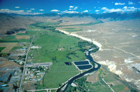
This view looks down the Salmon River almost directly north (5° east of true north) of the city of Salmon, Idaho. Clark himself could not see the confluence of the east and west forks of “Lewis’s River” (just out of the picture at bottom center) on his way past here on August 21, 1805. The road he was following was a mile or two to the east, on what is today called the Discovery Hills, but which he vaguely recalled as just “a point of high land.” (Ordway later recalled the same road as “eight miles without water.”) Clark looked back upstream when he reached the Salmon River at the mouth of “Sammon run,” now known as Carmen Creek. “The bottoms,” he wrote, “is wide & rich from some distance above the place I struck the east fork.” Those verdant bottoms have come to be called the “Big Flat”—an especially ironic expression in a country where much of the flat land is standing on end.
At Carmen Creek he noticed another road, which Toby told him led over the mountains toward the Missouri River.
Clark’s Can-do Spirit
Clark’s firm but quiet can-do spirit survived the arduous trip up and down the steep draws and ridges between Tower Creek and North Fork, and as if it had not boded ill after all, he continued around the bend of the river and entered the stretch that would test his will and his mettle as an officer.The south-facing slopes were sparsely timbered, and mainly surfaced with talus and scree. Travel over such terrain is dangerous enough in sturdy hiking or climbing shoes, but by now those men were all shod in soft-soled moccasins.
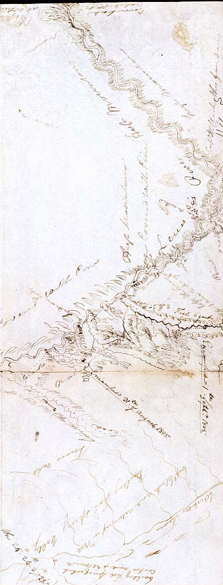
On 23 August 1805, Toby, the guide Clark had hired at the first Lemhi Shoshone camp, led Clark more than 25 miles down the Salmon River from the forks to a high point somewhere out of the lower right-hand corner of this photo. From there he directed Clark’s attention to the river “for about 20 miles lower & pointed out the dificulty.” He also pointed out a nearby road “which he Said went to a large river which run to the north on which was a Nation he called Tushapass [Tushepaws, i.e. Flathead or Salish].” It would have led over the ridge northward to the West Fork of the Bitterroot River. Toby even “made a map of it.”
Shoshone Confirmation
It seemed as if the old Shoshone took some pride in proving he and his friends had been right all along, and Clark was not above admitting it. “Those rapids which I had Seen,” Toby had assured him, “was Small & trifleing in comparrison to the rocks and rapids below, at no great distance & The Hills or mountains were not like those I had Seen but like the Side of a tree Streight up.” At one of the rapids Clark had seen:
the mountains Close so Clost as to prevent a possibility of a portage with great labour in Cutting down the Side of the hill removeing large rocks &c. &c. all the other may be passed by takeing every thing over Slipery rocks, and the Smaller ones Passed by letting down the Canoes empty with Cords, as running them would certainly be productive of the loss of Some Canoes.
Even on the stretch of the river he had seen so far there were five “shoals” that could not even be run with empty canoes, and portaging baggage with horses was clearly impossible.
In fact, just to hike down the canyon would have required them to cross the river at almost every bend, and the swiftness of the current made that too dangerous to contemplate. Even if Clark had been inclined to subject the men to those rigors, “those difficuelties and necessary precautions would delay us an emince time in which provisions would be necessary. (we have but little and nothing to be precured in this quarter except Choke Cheres & red haws not an animal of any kind to be seen.)”
So, on this river, on the 23rd of August, 1805, the centuries-old fantasy of a “water route across the continent for the purposes of commerce” dissolved in the roar of an unimaginable torrent–one of the most dangerous, unforgiving rivers in North America. Many years later, when its character became generally known, it would be called “The River of No Return.”
Clark carved his name on a pine tree and led his 11-man party back toward their camp of 21 August 1805 at the mouth of Carmen Creek. Given the ruggedness of the whole round trip, and the hazards of walking it in moccasins, accidents were bound to happen.”I Sliped & bruised my leg verry much on a rock,” he admitted.
Alternatives
Meriwether Lewis was still at Camp Fortunate, readying things for the portage across the divide, and still hoping that Cameahwait had exaggerated and that Clark and his men were already busy hewing canoes for the resumption of their riverine voyage. Actually, not certain where Lewis was on the 24th, or how soon they might be reunited and ready to proceed on, that day Clark wrote Lewis a letter outlining three alternatives for his consideration.
The first was to buy at least one horse for every man, extend Toby’s engagement as guide, and “proceed on by land to Some navagable part of the Columbia River.” The second was to divide the party in two, with–he still couldn’t let go of the fantasy–with “one part to attempt this deficuelt river with what provisions we had, and the remainder to pass by Land on hose back Depending on our gun &c for Provisions &c. and come together occasionally on the river.” The third was to send one party to “attempt” to cross the mountains on horseback, while the other would return to the Great Falls of the Missouri, collect the contents of the caches, follow the Indian route across the Rockies, and rendezvous with the canoes on the Columbia. Actually, his list may have been merely an exercise in tactical planning for himself to ponder as he organized his thoughts on paper. The first plan clearly was the most reasonable.
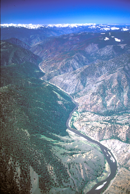
This view, taken in May of 2001, bears 240° TN, or nearly west-southwest. Although the Salmon River looks rather placid from 1,200 feet AGL (above ground level), its character at water level is suggested by the numerous places where cliffs had to be blasted back to make room for the road that etches the north (right) bank. There is even one spot where it was easier to climb over a low wooded ridge than to cut it away. The road was begun in 1933 by crews from the Civilian Conservation Corps. Their objective was to build a 150-mile water-level route from North Fork to the town of Riggins, Idaho, on the west side of the Salmon River Mountains. When the approach of World War II in 1939 forced construction to cease, 46 miles of it had been completed on the east end from North Fork and 27 miles upstream from Riggins on the west end. Both segments are still in use, chiefly for access to fishing sites and wilderness trailheads.[1]Cort Conley, Idaho for the Curious: A Guide (Cambridge, Idaho: Backeddy Books, 1982), 588–90.
River of No Return
The only populated spot on the eastern leg of the Salmon River Road is Shoup, a general store with two gas pumps and a post office situated 17 miles downriver from North Fork. Named for George H. Shoup (1836–1904), the first Territorial governor and the first governor elected after Idaho became a state in 1890. For a time Shoup was the center of a small but lively community of miners and their families. The brown-and-black area on the ridge west of Shoup and Spring Creek Canyon is the scar of the Sheepeater Fire of 1998.
For 180 of its total length of 425 free-flowing miles, the mainstem Salmon River is the principal attraction in a canyon that is 1000 feet deeper than the Grand Canyon of the Colorado. For the past 35 to 45 million years the main stem of the Salmon River has been slicing its way down through the 65-million-year-old granites of the Idaho Batholith. The river’s reputation for wildness is based on its speed: In steep drops separated by comparatively quiet pools, it drops an average of 12 feet per mile between North Fork and Riggins.
The River of No Return Wilderness was established in 1980, and later renamed in honor of Idaho’s Senator Frank Church (1924–1984), who had been a leader in securing passage of the Wilderness Act of 1964. At 2.3 million acres (3,594 square miles), this is the largest designated wilderness area in the lower 48 states. Its northern boundary is defined by the Magruder Road, which separates it from the 1,340,460-acre (2,095 square miles) Selway-Bitterroot Wilderness, which is the third-largest in the lower 48. The Salmon River, a major tributary of the Snake River, is the centerpiece of “The Frank.”
Floating the Salmon Today
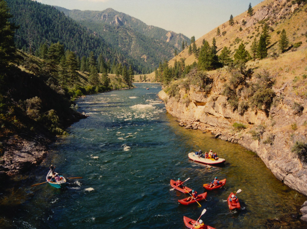
Salmon River above Shoup, Idaho
Roy Luck, Flicker, www.flickr.com/photos/royluck/6893683515/. Licensed under the Creative Commons Attribution-ShareAlike 2.0 Generic license.
Lewis and Clark were contemplating their Salmon River float trip during the best part of the year in terms of water level and weather conditions–just right for a family trip today. Their problem was their means of travel. The only kind of rivercraft they and their men had the skills, tools, and time to build were dugout canoes carved from green trees. To begin with, they needed straight, sound trunks a minimum of three feet in diameter for about 30 feet of their length. In the mountains they used ponderosa pines, the largest species that grew near the rivers. With the inside hollowed out and the ends tapered to a point for stability in the current, they have been said by some historians to have weighed well over a ton when dry and empty; crew and baggage could add another 1,500 to 2,000 pounds. With only a few inches of freeboard they readily shipped water in the rapids, and even in comparatively calm stretches when wind kicked up waves. Handling them required strength, skill, balance, and unremitting vigilance.
Today, given the proper equipment and qualified guides, a float on the Salmon is not work but play for thousands of people every year, mainly from late June through early September. Prime time for a high-adventure float is early spring, when the steepest standing waves push the upper limits of Class IV. A typical trip begins at Corn Creek, 47 miles by road below the settlement of North Fork, and ends 70 miles downriver at Long Tom Bar, a short distance above Riggins, Idaho.
For a century and a half the Salmon fully deserved its cognomen as “The River of No Return,” for it accommodated one-way traffic only. River commerce, which was a steady, high-volume business for many years, necessarily included the sale of the freight boat as lumber at the lower terminal, Lewiston, Idaho, at the mouth of the Snake River. But 20th-century technology would not be restrained, and so part of the law that established “The Frank” in the 1980s grandfathered jetboats on it, by permit, for the pleasure and convenience of recreationists who wish to, and can afford to, return after all.
Notes
| ↑1 | Cort Conley, Idaho for the Curious: A Guide (Cambridge, Idaho: Backeddy Books, 1982), 588–90. |
|---|
Experience the Lewis and Clark Trail
The Lewis and Clark Trail Experience—our sister site at lewisandclark.travel—connects the world to people and places on the Lewis and Clark Trail.
Discover More
- The Lewis and Clark Expedition: Day by Day by Gary E. Moulton (University of Nebraska Press, 2018). The story in prose, 14 May 1804–23 September 1806.
- The Lewis and Clark Journals: An American Epic of Discovery (abridged) by Gary E. Moulton (University of Nebraska Press, 2003). Selected journal excerpts, 14 May 1804–23 September 1806.
- The Lewis and Clark Journals. by Gary E. Moulton (University of Nebraska Press, 1983–2001). The complete story in 13 volumes.


