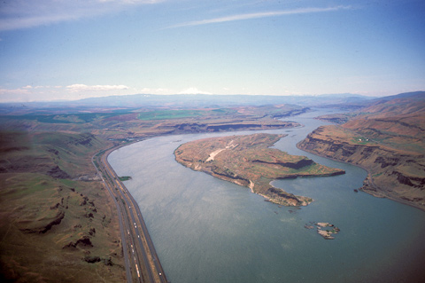
On the north (right) side of Miller Island, which Private Whitehouse described as “an Island of Rocks, which had towers of solid Rock on it,” the Columbia’s main channel was obstructed by “a very rough roaring rapid.” Thus on that day–22 October 1805–the Corps took the narrower south channel. The once rough, steep channels of the Columbia River now lie beneath the wind-ruffled waters of Lake Celilo, which begins at The Dalles Dam, ten miles downstream.
Near the west end of the island, they passed a sizeable tributary local Indians called To war ne hi ooks. The journalists left us no hint that the word they heard as Towarnehiooks was a Chinookan expression meaning “enemies,” but they did note that the Indians in this neighborhood stayed on the north side of the Columbia, from fear of the Paiutes who lived along that southern tributary. The explorers renamed it Clark’s River, but fur traders in the 1820s came to know it as the Riviere des Chutes–”River of the Falls.” Today, it’s abbreviated to “Deschutes.” The “chutes” that the river’s French name may have referred to were later called Celilo Falls, until they were submerged by the reservoir behind John Day Dam.
Headed upstream on 21 April 1806, most of the Corps camped on the north side of the river opposite the island’s west end. The men were somewhat scattered, most of the company leading the ten pack horses they had so far bought, the rest manning the two remaining canoes. While here, Lewis purchased one more horse “for a trifle”–the equivalent, he said, of ten shillings in Virginia currency.
Food was still scarce for native and traveler alike. So was firewood. Lewis characterized the local natives as “poor, dirty, proud, haughty, inhospitable, parsimonious and faithless in every rispect,” and he felt it advisable to treat them menacingly. Out of spite he ordered the spare paddles and poles to be burned in an evening bonfire–a vindictive gesture in this treeless desert where fuel wood was generally non-existent.
The ragged, steep channel of the native Columbia River is now hidden beneath the windy waters of Lake Celilo–the meaning of the word long-lost to memory–which extends from The Dalles Dam, two miles downstream beyond Miller Island, and John Day Dam, twenty miles behind the camera.
From Discovering Lewis & Clark from the Air
Photography by Jim Wark
Text by Joseph Mussulman
Reproduced by permission of Mountain Press
Experience the Lewis and Clark Trail
The Lewis and Clark Trail Experience—our sister site at lewisandclark.travel—connects the world to people and places on the Lewis and Clark Trail.
Discover More
- The Lewis and Clark Expedition: Day by Day by Gary E. Moulton (University of Nebraska Press, 2018). The story in prose, 14 May 1804–23 September 1806.
- The Lewis and Clark Journals: An American Epic of Discovery (abridged) by Gary E. Moulton (University of Nebraska Press, 2003). Selected journal excerpts, 14 May 1804–23 September 1806.
- The Lewis and Clark Journals. by Gary E. Moulton (University of Nebraska Press, 1983–2001). The complete story in 13 volumes.


