It is the flux, the fragility, the role of happenstance,
and the waywardness of human nature
in the handing-down of place-names
that make their study so worthy a subject.
Preserving Memories
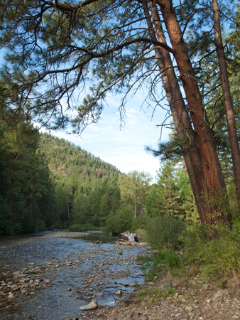
Lolo Creek (Montana)
© 10 September 2009 by Kristopher K. Townsend. Permission to use granted under the Creative Commons Attribution-Share Alike 4.0 International license.
On the map that General William Clark prepared for publication as a fold-out in The History of the Expedition (1814), he printed 148 place-names in the region that, since 1889, has constituted the state of Montana. Twenty of them were Indian names of rivers and creeks that Clark entered either in phonetic spellings or English translations. The remaining 128 names, all of which were chosen by the captains, fell into three categories. First, the individual members of the Corps of Discovery were memorialized, along with Lewis’s dog Seaman, some prominent political figures including their President, and three of the captains’ female friends–Judith, Maria, and “Marthey.”[2]Clark named the stream after the obscure but “Selibrated M. F” and immediately explained that her given name was “Marthey.” Lewis partially clarified Clark’s naming on … Continue reading Special events, situations and occurrences comprised the second group—Hungery Creek, Flattery Run [see The Portage Route]. Third and most numerous were places named for their own remarkable characteristics or associations–the Milk River and Shishequaw Mountain [Haystack Butte].[3]Ibid., 83.
There is another category that toponymists call “transfer names,” which are borrowed from a different place or time and applied to a new or remote place to preserve memories of previous experiences.[4]George R. Stewart, “A Classification of Place Names,” Names, vol. 2 (1954), 6, 9. This type of place-name appeared in the west with increasing frequency as settlers gathered into communities where they could share the social, political, religious or national loyalties that were their birthrights, towns in Montana such as Glasgow, Havre, Malta, Zurich, and the like. A transfer name was often more subtly created by the addition of “City” to any dedicatory name in order to emphasize the founders’ high hopes for futures comparable to those of older and larger communities back east. There was one possible example of a transfer name in Lewis and Clark’s gazetteer.
Lewis and Clark’s Montanan Names
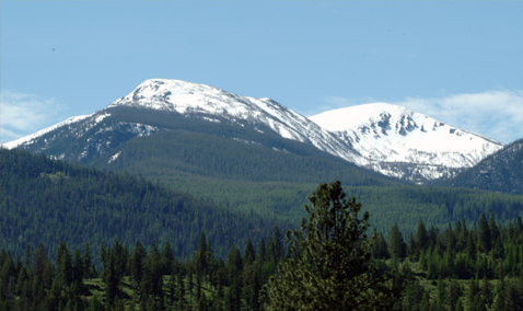
Two of the Corps’ horses strayed off during the night of September 10, 1805, and the search for them lasted until noon the next day, so the party didn’t leave camp until 3:00 on the “Verry worm” afternoon of the 11th. Nevertheless, they covered seven miles in what remained of the evening, noting the “hills on the right high and ruged, the mountains on the left high & Covered with Snow” that made them look like it was the middle of winter up there. The Corps “Encamped at Some old Indian Lodges” on the north bank of the creek, in full view of these peaks to the south. Although less jagged than some they had seen as they rode north down the Bitterroot Valley, this gently curving skyline could not have done much to lessen any sense of foreboding the men may have felt.
From the campsite they knew as “Travellers-rest,” they may have caught a glimpse of the mountaintop, but the view from their September 11th campsite is much more dramatic. From the latter perspective one can see that the summit actually is a narrow mountain crest formed of two peaks connected by a narrow ridge. The summit of the northern end of the crest reaches an altitude of 9,096 feet MSL; the peak at the southern end of the crest is a mere 44 feet higher, at 9,140 feet.[5]The Lolo National Forest, containing 2 million acres (8,000 square km; 3,125 square miles), was established in 1906. That is the summit that was officially named “Lolo Peak” in 1898 by the Board on Geographic Names of the USGS.
The press run of 2,000 copies of the initial issue of the History turned into a sale of only 1,417. That, and the ineffectual marketing that accompanied the publisher’s failing fortunes, limited its circulation among American readers. (Clark waited two years for his copy to reach him in St. Louis.) Printings in England, Ireland and on the Continent followed the Philadelphia premiere almost immediately, and for several decades they continued to feed an eager European audience, and even sifted into the trans-Atlantic readership at bloated import prices. But there wasn’t another American edition until 1842, when Harper and Brothers of New York came out with a “revised and abridged” version by Archibald M’Vickar (1785-1849) that was introduced into the voluminous, cheap Harper’s Family Library, which contained 187 different titles priced at 45 cents each. In its way, and via the more than 20 printings limited to about 250 copies each, M’Vickar’s tawdry effort satisfied an uncritical American popular market for Lewis and Clark for the next fifty years, and didn’t expire until 1917. Its fold-out map, a much-flawed knockoff of Clark’s masterpiece, was practically useless as a guide to the expedition’s route. “Travellers-rest” was iterated eleven times by M’Vickar, a reduction by two-thirds of the number in Biddle’s paraphrase.
By the time Elliott Coues’ studiously annotated reprint of the Biddle-Allen edition appeared in 1892, 10 of the 20 Indian place-names, and 111 of the 128 American names that the two captains had more or less thoughtfully consigned to history were replaced by later preferences, leaving only 27 of the originals on the map of Montana. One by one, either deliberately or from lack of awareness, the rest had been updated by fur trappers and traders with very personal standards of naming; by steamboat captains with narrower needs; by young surveyors, scientists and geographers with new perspectives on the land; and by emigrants, or “pilgrims,” whose final destinations were defined by their own sense of place–by whatever gave them comfort. In other words, most of the abandoned Lewis-and-Clark names were simply insubstantial or irrelevant. As Donald Jackson put it, “they deserved no better fate” than to be thrown away.
Lolo Etymology: A Diaphanous Fabric
In the words of the American poet Kim Robert Stafford, “a place is a story happening many times.” A prime example of that, and of Jackson’s epigraph in the heading of this page, is the four-letter word “Lolo,” which grew to be so important by 1900 that it became the keyword in any narrative of that crucial, do-or-die episode in Lewis and Clark’s journey, the crossing of the Bitterroot Mountains. Thus it has earned a permanent berth in their lexicon of place-names. In fact, Gary Moulton, the editor of the University of Nebraska Press edition of the journals, indexed “Travelers’ Rest” under “Lolo,” perhaps for the sake of clarity.
This study will lead us along numerous threads of a larger story, beginning with the name Lewis and Clark chose for the stream they followed and slept beside. They met some Nez Perce men at the start, but apparently none was named Lolo, so we must seek its earliest appearances elsewhere–in documents created by John Work and Father Pierre-Jean De Smet. We read the field notes and journals of David Thompson and John Mullan. We follow inexplicable tropes on the name through some of the cartographic monuments of the 19th century. Then we’ll turn to the ledgers and letters of pioneer John Owen, and the accounts of William Ashley. We’ll examine the sacramental records of the second of the two St. Mary’s Missions in the valley of the Bitterroot River, then repeat the story that Olin D. Wheeler ferreted out of the memories of some “old timers.” We’ll see that compulsive quests for rational explanations of the name and its owner’s life are colorful threads at best, although they held their own brief fascinations. Then we’ll browse through the records of the Geographic Names Information System. The short history of Chinuk Wawa (Chinook Trade Jargon) will reveal a surprising coincidence. Finally, we will meet one thoroughly believable Lolo, complete with a photograph to prove his existence.
It is hoped that a careful and thorough inquiry into the history of Lolo as a place-name will lead to a better appreciation of “the flux, the fragility, the role of happenstance, and the waywardness of human nature” that are woven into its diaphanous fabric.
Notes
| ↑1 | Donald Jackson, “Lewis and Clark Place-Names in Montana,” in Among the Sleeping Giants: Occasional Pieces on Lewis and Clark (Urbana: University of Illinois Press, 1987), 89. |
|---|---|
| ↑2 | Clark named the stream after the obscure but “Selibrated M. F” and immediately explained that her given name was “Marthey.” Lewis partially clarified Clark’s naming on the same date with the statement, “This stream my friend Capt. C. named Marthas river |
| ↑3 | Ibid., 83. |
| ↑4 | George R. Stewart, “A Classification of Place Names,” Names, vol. 2 (1954), 6, 9. |
| ↑5 | The Lolo National Forest, containing 2 million acres (8,000 square km; 3,125 square miles), was established in 1906. |
Experience the Lewis and Clark Trail
The Lewis and Clark Trail Experience—our sister site at lewisandclark.travel—connects the world to people and places on the Lewis and Clark Trail.
Discover More
- The Lewis and Clark Expedition: Day by Day by Gary E. Moulton (University of Nebraska Press, 2018). The story in prose, 14 May 1804–23 September 1806.
- The Lewis and Clark Journals: An American Epic of Discovery (abridged) by Gary E. Moulton (University of Nebraska Press, 2003). Selected journal excerpts, 14 May 1804–23 September 1806.
- The Lewis and Clark Journals. by Gary E. Moulton (University of Nebraska Press, 1983–2001). The complete story in 13 volumes.


