Wheeler’s Lolo Crossing
Photo attributed to Ralph DeCamp, 1902, for Olin D. Wheeler, The Trail of Lewis and Clark. See also Wheeler’s “Trail of Lewis and Clark”
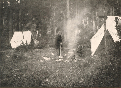
Olin Wheeler (seated beside the fire) and W. H. Wright are shown here in their camp at Weitas Meadows, the headwaters of Hungery Creek and Collins (Lolo) Creek in Idaho, in 1902. Since the artist and photographer Ralph DeCamp of Helena, Montana, was with them, it may have been he who took this picture.
One of Wheeler’s most successful efforts to amplify any part of Lewis and Clark’s route was his exploration of the Lolo Trail. For that he relied heavily on Elliott Coues’ 1893 annotations to the expedition’s narrative, where Clark’s courses and distances of the Bitterroot crossing were published for the first time. But that by itself didn’t suffice. “With half-a-dozen of the best modern maps of Idaho before me,” Coues explained, “there is not one on which I can dot the trail of the Expedition in detail. The country has not yet been sectionized [surveyed], and our topographical knowledge is still too vague to be of any exact use.”[1]The History of the Lewis and Clark Expedition by Meriwether Lewis and William Clark, Elliott Coues, ed., 4 vols., 1893; reprint, 3 vols. (New York: Dover, [1965]), 2:595n.
Wheeler also sought advice from C.C. Van Arsdol, a civil engineer for the Northern Pacific Railway, and James Stuart, a member of the Nez Perce Tribe. Most of all he relied on W. H. Wright of Spokane, Washington, who had himself studied and explored the Northern Nez Perce Trail over a period of years. In 1899, Wheeler and Wright started west from Lolo, Montana, but got only as far as White Sand Creek, just over the crest of the Bitterroot Divide, before an early autumn snowstorm interrupted their plans. Three years later Wheeler and Wright returned, accompanied by painter and photographer Ralph De Camp, this time proceeding eastward from Kamiah, Idaho, through Weippe Prairie and across the mountains to Travelers’ Rest. Wright was a man who, Wheeler wrote, had for years “intelligently explored nearly every square mile of the Clearwater [River] country,” and it was his guidance that had enabled him to be far more successful than he had had reason to expect in locating the original Indian trail. An anonymous reviewer for The Independent magazine agreed: “There has long been matter for dispute as to many portions of this trail, but is likely that Mr. Wheeler has closed the controversy.”[2]“The Pathfinders Again,” The Independent, 57 (15 September 1904), 621.
Methodology
Wheeler recorded his discoveries on a USGS topographic map based on 1,000-foot contours, the best available at the time. To generalize his impressions, Wheeler chose a timely analogy:
A great trail like the Lolo is much like a great trunk line of a railway. Here and there, at certain and favorable places, will be found lines of parallel trails, like parallel railway sidings, all merging, at some point, into the main track or trail; branch trails also, like branch lines, will now and again be found. So it was and is here.
Wheeler’s work represented a forward step in his time, but much was yet to be learned about the “face of the land” in the Bitterroot Mountains that had to await the advent of aerial photography, which began to evolve in the 1920s. Since the 1980s, studies using GPS resources, combined with extensive ground-truthing, have led to new and more detailed interpretations of the Northern Nez Perce Trail.
Lochsa River Controversy
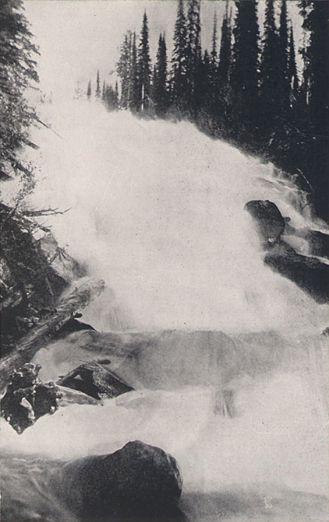
Hungery Creek, below the spot where Clark and his six hunters found a stray Indian horse, and killed it for food on 19 September 1805.
Editor’s Note: Wheeler seems to have confused the location of this waterfall with a different creek. Hungery Creek does not have any waterfalls such as the one in this photo.—Kristopher K. Townsend
Wheeler was puzzled by the Corps’ deviation from the Nez Perce Trail on 14-15 September 1805 when, after leaving their Glade Creek camp, they clambered over the highest and steepest mountain they had yet encountered, swiftly descended to the head of the Lochsa River, and camped at an Indian salmon-fishing hole. The next day they had to climb up Wendover Ridge back up to the main trail. Biddle had referred to the expedition’s Lemhi Shoshone guide only once, without naming him. But Wheeler had learned of “Toby” through study of the photographic copies of the original journals he had in hand.
What the old guide meant, if he really knew what he was doing, by taking the expedition down into this caÒon, and around by the old fishery, is inconceivable, for they were simply compelled to climb out again and regain the main trail on the high ridge to the north. It was a case of misleading, wholly, I think, unless, for some reason not specified, the Captains insisted upon this detour. Mr. Stuart and I discussed this détour at length, and he can see no occasion whatever for it.
It would yet require many eyes many years to comprehend certain passages in the original journals, and to agree that no certain answer would ever be found to conundrums like this.
Steven’s Opinion
Actually, at mid-century Isaac Stevens, who led the Pacific Railroad Surveys of 1853-55 had hit on a truth about Kuseyneiskit—The Road to the Buffalo—that should have helped to resolve all such questions. In his own words, this is what he learned:
An examination of Lewis and Clark’s narrative shows this curious incident: The Indians impressed them with the idea that the route which they pursued was altogether the most practicable of any route across these mountains, and yet it is unquestionably the worst route of the whole. They adopted the same policy in reference to these passes which they afterwards did in the Yakima country with the parties of [Stevens’s] exploration. Indeed, so tenacious not only are the Indians, but even the missionaries, of their right of occupation, that it is impossible for them to resist the inclination to underrate the country and the routes, in order to keep white people out of it. Now, this route of Lewis and Clark is frequently taken by Indians at the present day, not because it is a good route, but because salmon and [camas] roots are found higher up the stream than on any other route, and it is a route, therefore, which furnishes them their food. They get high up the Koos-koos-kia [i.e., the Lochsa River] on this route large stores of salmon, indispensable to their subsistence on their way to the plains of the Missouri.[3]Reports of Explorations and Surveys to ascertain the most practicable and economical route for a railroad from the Mississippi River to the Pacific Ocean, 1853-55 (Washington, D.C.: Thomas H. Ford, … Continue reading
Stevens’s observations suggest that Toby’s guidance, whether or not he fully understood the captains’ objectives, was motivated by one or both of two possible but conflicting motives. Either he was determined, as a tour guide par excellence, to impress the Americans with the values his people placed on K’useyneiskit, or he was bound, in the best interests of his people, to make the foreigners regret they had ever invited themselves to trespass on Indian lands.
Notes
| ↑1 | The History of the Lewis and Clark Expedition by Meriwether Lewis and William Clark, Elliott Coues, ed., 4 vols., 1893; reprint, 3 vols. (New York: Dover, [1965]), 2:595n. |
|---|---|
| ↑2 | “The Pathfinders Again,” The Independent, 57 (15 September 1904), 621. |
| ↑3 | Reports of Explorations and Surveys to ascertain the most practicable and economical route for a railroad from the Mississippi River to the Pacific Ocean, 1853-55 (Washington, D.C.: Thomas H. Ford, Printer, 1860), Vol. XII, Book I, p. 249. |
Experience the Lewis and Clark Trail
The Lewis and Clark Trail Experience—our sister site at lewisandclark.travel—connects the world to people and places on the Lewis and Clark Trail.
Discover More
- The Lewis and Clark Expedition: Day by Day by Gary E. Moulton (University of Nebraska Press, 2018). The story in prose, 14 May 1804–23 September 1806.
- The Lewis and Clark Journals: An American Epic of Discovery (abridged) by Gary E. Moulton (University of Nebraska Press, 2003). Selected journal excerpts, 14 May 1804–23 September 1806.
- The Lewis and Clark Journals. by Gary E. Moulton (University of Nebraska Press, 1983–2001). The complete story in 13 volumes.


