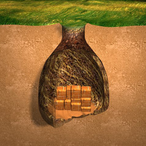
Lewis and his group open a cache made at the White Bear Islands above the Great Falls of the Missouri and discover it flooded over the winter. His plant specimens and several medicines are ruined. Drouillard has not yet returned from his quest to find missing horses.
At the headwaters of the Missouri, Sgt. Ordway and nine others head down the Missouri in the dugout canoes. Clark and those remaining in his group head up the Gallatin River valley on horses. Sacagawea recommends they head to present Bozeman Pass.[1]For more on the captains’ strategy and various groups, see Dividing Forces at Travelers’ Rest.
Ordway Sets Out for the Great Falls
by Yellowstone Public Radio[2]Originally aired weekdays by Yellowstone Public Radio during the Bicentennial observance of 2003-2006. Narrated by Hal Hansen. Scripts by Whit Hansen and Ed Jacobson. Produced by Leni Holliman. © … Continue reading
Lewis Finds a Flooded Cache
The White Bear Islands
removed above to my old station opposite the upper point of the white bear island. formed our camp and set Thompson &c at work to complete the geer for the horses.
—Meriwether Lewis
A Flooded Cache
had the cash opened found my bearskins entirly destroyed by the water, the river having risen so high that the water had penitrated. all my specimens of plants also lost. the Chart of the Missouri fortunately escaped.
—Meriwether Lewis
Wet Papers and Medicines
opened my trunks and boxes and exposed the articles to dry. found my papers damp and several articles damp. the stoper had come out of a phial of laudinum and the contents had run into the drawer and distroyed a gret part of my medicine in sucuh manner that it was past recovery.
—Meriwether Lewis
More Worries
waited very impatiently for the return of Drewyer he did not arrive. Musquetoes excessively troublesome insomuch that without the protection of my musquetoe bier I should have found it impossible to wright a moment.
—Meriwether Lewis
Weather Diary (Lewis)
State of the weather at rise
Wind at rise
State of the weather at 4 P. M. Wind at 4 P. M. fair N E fair N E —Meriwether Lewis
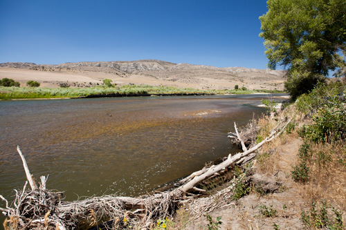
Mouth of the Gallatin
© 23 July 2013 by Kristopher K. Townsend. Permission to use granted under the Creative Commons Attribution-Share Alike 4.0 International license.
Above: The photographer is on the left bank of the Gallatin. The Missouri River flows from left to right below the white cliff.
Clark Goes Up the Gallatin
Reunion at the Headwaters
Set out early this morning and proceeded on very well to the enterance of Madicines [madison] river at our old Encampment of the 27th July last at 12 where I found Sergt. Pryor and party with the horses, they had arived at this place one hour before us. his party had killed 6 deer & a white bear
—William Clark
Up the Gallatin River
the horses feet are very sore and Several of them can Scercely proceed on. at 5. P. M I Set out from the head of Missouri at the 3 forks, and proceded on nearly East 4 miles and Encamped on the bank of Gallitines River which is a butifull navigable Stream.
—William Clark
Sacagawea Recommends a Pass
The indian woman [Sacagawea] who has been of great Service to me as a pilot through this Country recommends a gap in the mountain more South which I shall cross.—.
—William Clark
Weather Diary (Clark)
State of the weather at Sun rise Wind at Sun rise State of the weather at 4 P. M Wind at 4 P M. fair S S E fair N E —William Clark[3]To assist the reader of this web page, the date column is omitted and some abbreviations have been spelled out.
Missouri River below the Headwaters
© 23 July 2013 by Kristopher K. Townsend. Permission to use granted under the Creative Commons Attribution-Share Alike 4.0 International license.
Ordway Paddles the Missouri
we parted I and 9 more proceeded on down the river with the canoes verry well. the wind a head So we halted little before night.
—John Ordway
Experience the Lewis and Clark Trail
The Lewis and Clark Trail Experience—our sister site at lewisandclark.travel—connects the world to people and places on the Lewis and Clark Trail.
Plan a trip related to July 13, 1806:

The Great Falls Portage is a High Potential Historic Site along the Lewis and Clark National Historic Trail managed by the U.S. National Park Service. It includes Sulphur Springs (open to the public) and Lower Portage Camp site (private land), and the Upper Portage Camp Overlook.
Three Forks of the Missouri is a High Potential Historic Site along the Lewis and Clark National Historic Trail managed by the U.S. National Park Service. The site a Montana State Park.
Notes
| ↑1 | For more on the captains’ strategy and various groups, see Dividing Forces at Travelers’ Rest. |
|---|---|
| ↑2 | Originally aired weekdays by Yellowstone Public Radio during the Bicentennial observance of 2003-2006. Narrated by Hal Hansen. Scripts by Whit Hansen and Ed Jacobson. Produced by Leni Holliman. © 2003 by Yellowstone Public Radio. |
| ↑3 | To assist the reader of this web page, the date column is omitted and some abbreviations have been spelled out. |


