“Of all the terrains the Lewis and Clark expedition traversed between 1803 and 1806, the route down the Snake and Columbia Rivers, amongst dark menacing rocks and through ferocious whitewater rapids, was perhaps the most thrilling, dramatic, and geologically fascinating. What Sergeant Patrick Gass observed to be “so much uniformity in the appearance of the country,” belied an exceptionally active and relatively recent geologic history.”
Related Pages
Columbia Gorge Waterfalls
by John W. Jengo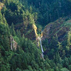
William Clark: “Saw 4 Cascades caused by Small Streams falling from the mountains on the Lard. Side.”
Columbia River Basalts
by John W. Jengo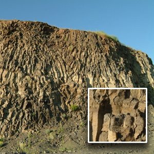
The region of the lower Snake River and the Columbia River’s course through the Columbia Plateau and Gorge experienced volcanic activity starting some 55 million years ago, although the expedition would primarily encounter rock units of Miocene-age.
Keffekill at Lake Lewis
A missing mineral specimen
by John W. Jengo
Near Wallula Gap, Meriwether Lewis apparently collected an enigmatic and long-missing mineral specimen that was never documented in the expedition journals.
The Sandy River
The "quicksand river"
by John W. Jengo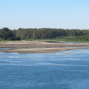
The expedition traveled out from under an ancient river channel frozen in time to a river discharging huge volumes of sediment in real time, the “quicksand river,” now known as the Sandy River.
A Submerged Forest
by John W. Jengo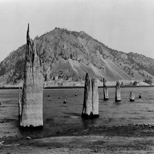
On 30 October 1805, Clark documented the presence of a submerged forest, which along with the burning bluffs of northeastern Nebraska, the “Burnt Hills” of North Dakota, and White Cliffs of the Missouri in central Montana, remain one of the expedition’s most famous geological observations.
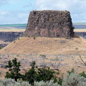
Monumental Rock
Clark's Ship Rock
by John W. Jengo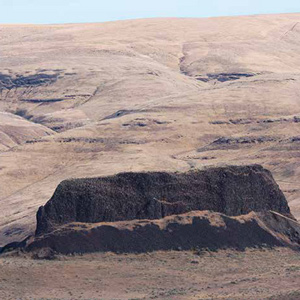
Dubbed “Ship Rock” on Clark’s route map, but now known as Monumental Rock, this distinct outcropping of the Lower Monumental Member of the Saddle Mountains Basalt is located on the south bank of the Snake River in Walla Walla County, Washington, just upriver of Lower Monumental Dam.
The Columbia River Gorge
Its geologic origin
by John W. Jengo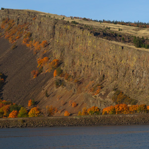
The consolidated rocks that compose the Gorge were formed by a complex interplay of Columbia River Basalt Group flood basalt deposition and basin subsidence, along with contemporaneous folding and faulting—not the Glacial Lake Missoula floods.
Beacon Rock
A remarkable, high and detached rock
by Joseph A. Mussulman![]()
“a remarkable high detached rock Stands in a bottom on the Stard [starboard, the navigator’s right] Side & about 800 feet high and 400 paces around”
Rooster Rock at Crown Point
by John W. Jengo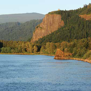
The promontory of Crown Point comes to mind when Clark mentions in his notebook journal that the expedition camped “under a high projecting rock.”
Hat Rock
The enlisted men must have recognized it at a glance, this pile of columnar basalt all together resembling a well-weathered gentleman’s hat with a work-worn brim. Two centuries later, it would be one of the few Lewis and Clark landmarks left above Columbia River.
Lake Missoula Floods
Route of the Lake Missoula Floods
by John W. Jengo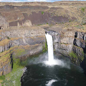
From the moment they dipped their paddles into the Snake River, the Lewis and Clark expedition would not only be following the path of multiple flood basalt flows, but also the route of the colossal Lake Missoula floods that so markedly scoured the basaltic landscape.
Geology of The Dalles
by John W. Jengo
Over four days (22-25 October 1805) the expedition would be navigating through one of the most exciting and difficult stretches of the entire water route to the Pacific. Several outstanding geological features were noted.
The Cliffs at John Day
Columbia River rock falls
by John W. Jengo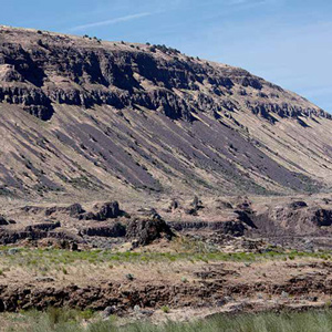
The 21 October 1805 rock fall geologic notation is likely referring to mass-wasting features along a fourteen-mile long stretch of dramatically steep slopes visible today between Blalock Canyon and the John Day River.
Phoca (Seal) Rock
by John W. Jengo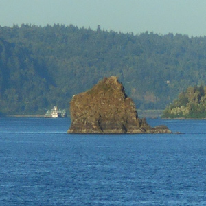
The mid-river island identified as “Phoca” and “Seal rock” on one of William Clark’s route maps is a compact landslide block that detached from the Cape Horn headland.
Experience the Lewis and Clark Trail
The Lewis and Clark Trail Experience—our sister site at lewisandclark.travel—connects the world to people and places on the Lewis and Clark Trail.
![]()
Discover More
- The Lewis and Clark Expedition: Day by Day by Gary E. Moulton (University of Nebraska Press, 2018). The story in prose, 14 May 1804–23 September 1806.
- The Lewis and Clark Journals: An American Epic of Discovery (abridged) by Gary E. Moulton (University of Nebraska Press, 2003). Selected journal excerpts, 14 May 1804–23 September 1806.
- The Lewis and Clark Journals. by Gary E. Moulton (University of Nebraska Press, 1983–2001). The complete story in 13 volumes.
This site is provided as a public service by the
![]()
Lewis and Clark Trail Alliance
with additional funding from the following:

