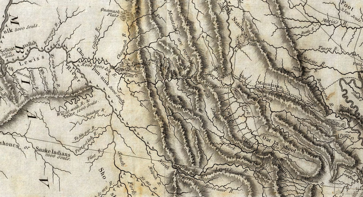
At Fort Clatsop, the captains worry about the enlisted men at the salt makers‘ camp in present Seaside, Oregon. Clark finishes a map of their route which according to Lewis includes “the most practicable and navigable passage” between the Great Falls of the Missouri and Travelers’ Rest—a trail they have not yet traveled.
A Few Sick Men
by Yellowstone Public Radio[1]Originally aired weekdays by Yellowstone Public Radio during the Bicentennial observance of 2003-2006. Narrated by Hal Hansen. Scripts by Whit Hansen and Ed Jacobson. Produced by Leni Holliman. © … Continue reading
Fort Clatsop Worries
We are very uneasy with rispect to our sick men at the salt works. Sergt. Pryor and party have not yet returned nor can we conceive what causes their delay.
—Meriwether Lewis
Map of Lewis and Clark’s Track, Across the Western Portion of North America
Clark’s 1814 Map (detail)
From Biddle’s paraphrase of the journals.[2]History Of The Expedition Under The Command Of Captains Lewis And Clark, To The Sources Of The Missouri, Thence Across The Rocky Mountains And Down The River Columbia To The Pacific Ocean. Performed … Continue reading
Above: This detail shows the shortcut Lewis took to reach to the Falls of the Missouri in 1806, over present-day Lewis and Clark Pass. No map as described in the captains’ journals on 14 February 1806 has been found. The missing map was likely used to create later maps such as Clark’s 1814 map.
Clark’s Map of the Country
I compleated a map of the Countrey through which we have been passing from the Mississippi at the Mouth of Missouri to this place. In the Map the Missouri Jefferson’s river the S. E. branch of the Columbia or Lewis’s river, Koos-koos-ke and Columbia from the enterance of the S. E fork to the pacific Ocian, as well as a part of Clark’s river and our track across the Rocky Mountains are laid down by celestial observations and Survey.
—William Clark
The Most Practical Route
we now discover that we have found the most practicable and navigable passage across the Continent of North America; it is that which we traveled with the exception of that part of our rout from the neighbourhood of the entrance of Dearborn’s River untill we arrived on Clarks river at the entrance of Traveler’s rest creek
—Meriwether Lewis
Weather Diary
aspect of the weather at rise
Wind at rise
aspect of the weather at 4 OC1 P.M. Wind at 4 O’Clock P.M. cloudy after fair & snow S. W. rain after rain, fair & rain S. W. very small quantity of snow fell last night not enough to cover the ground somewhat colder this morning. the sun shown only a few moments.
—Meriwether Lewis[3]To assist the reader, the editor of this web page has omitted the “Day of ye Month” column and spelled out some abbreviations.
Experience the Lewis and Clark Trail
The Lewis and Clark Trail Experience—our sister site at lewisandclark.travel—connects the world to people and places on the Lewis and Clark Trail.
Plan a trip related to February 14, 1806:

Fort Clatsop is a High Potential Historic Site along the Lewis and Clark National Historic Trail managed by the U.S. National Park Service. The site is managed by the Lewis and Clark National and State Historic Parks.
Notes
| ↑1 | Originally aired weekdays by Yellowstone Public Radio during the Bicentennial observance of 2003-2006. Narrated by Hal Hansen. Scripts by Whit Hansen and Ed Jacobson. Produced by Leni Holliman. © 2003 by Yellowstone Public Radio. |
|---|---|
| ↑2 | History Of The Expedition Under The Command Of Captains Lewis And Clark, To The Sources Of The Missouri, Thence Across The Rocky Mountains And Down The River Columbia To The Pacific Ocean. Performed During The Years 1804-5-6. By order of the Government Of The United States. Prepared For The Press By Paul Allen, Esquire. In Two Volumes. Vol. I. Philadelphia: Published By Bradford And Inskeep, New York. J. Maxwell, Printer. 1814 … Vol. II. |
| ↑3 | To assist the reader, the editor of this web page has omitted the “Day of ye Month” column and spelled out some abbreviations. |


