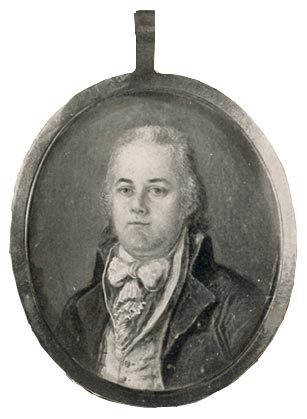
Miniature portraits were fashionable in America for more than a hundred years, from the middle of the 18th century until the photographic portrait eclipsed the old genre near the end of the 19th. The casual spirit of friendly intimacy was heightened by the oval shape and the small size—sometimes only a couple of inches in height.
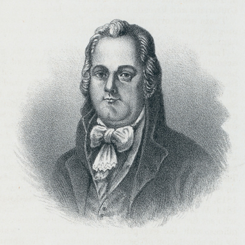
There are but few known portraits of Andrew Ellicott. He sent the original of this miniature to his wife Sally from New Orleans in February 1799. The artist, he told Sally, was “a spanish lady,” who had also produced several copies of it for him. Undoubtedly, all were in full color. Either the original or one of the copies, from which the above photograph was made, was in private ownership at the turn of the 20th century. Its present location is unknown.
The fact that he could afford the copies, plus the artist’s anonymity, suggest that the painter was a commercial artist who combined technical skill with speed and competitive pricing. Ellicott himself considered the result “an excellent likeness.”[1]Catharine Van Cortlandt Mathews, Andrew Ellicott: His Life and Letters (New York: Grafton Press, 1908), 164-65.
Ellicott’s life was busy in 1803.[2]This page has been condensed by Nancy Davis from her article, “Andrew Ellicott: Astronomer, Mathematician, Surveyor,” We Proceeded On, Vol. 24, No. 3 (August 1998), 28-32. He had moved from Philadelphia to Lancaster just the year before to undertake the office of Secretary of the Land Office, to which he had been appointed by Governor McKean. He was publishing his journals of a Florida survey including maps and observations. And now came a message from the President of the United States about a secret mission. Ellicott’s part was to welcome into his new home a young military officer who was to be instructed in the art of celestial and field observations.
President Jefferson and Ellicott knew each other well. In 1783, Ellicott had been part of the team surveying, planning and mapping the new Federal City. He served in the Maryland militia during the War for Independence, earning the rank of major.
No one could accuse Jefferson of favoritism. Ellicott was one of the best surveyors of his time, renowned today for the accuracy of his work. He was appointed Surveyor General of the United States in 1792. Ellicott’s personal history was particularly applicable to the mission at hand. Just seven years earlier, in 1796, Ellicott had traveled via the Ohio and Mississippi Rivers to survey the U.S. and Spanish Florida border. In 1798, still on the Florida survey, Ellicott sent a coded letter to the State Department describing information he had secretly received of payoffs by Spain to four Americans, including Lewis’s own commanding officer, General James Wilkinson.[3]On the subject of coded letters, see Jefferson-Lewis Cryptology.
Training Lewis
In a letter to Jefferson on 6 March 1803, Ellicott agreed to train Lewis. For the Expedition, he recommended an Arnold chronometer, artificial horizons and methodologies for determining accurate latitude and longitude, noting that the calculations should be made after the return of the Expedition.[4]Donald Jackson, ed., Letters of the Lewis and Clark Expedition with Related Documents, 1783-1854, 2nd ed., 2 vols. (Urbana: University of Illinois Press, 1962), 1:23-25. Ellicott and Jefferson arranged for the construction of a sextant and portable horizon to be made with Ellicott’s supervision. On 20 April 1803, Lewis wrote Jefferson from Lancaster that he had begun taking observations with Ellicott’s guidance. Lewis described Ellicott as “extremely friendly and attentive, . . . and is disposed to render me every aid in his power.”[5]Ibid., 40.
By May 1803, both Ellicott and Robert Patterson had become convinced that a sextant would be more accurate in obtaining longitude than the more fragile theodolite. They recommended that Lewis secure two sextants, two artificial horizons, one good Arnold’s chronometer, one surveyor’s compass (with a ball and socket), a two-pole chain and one set of plotting instruments.[6]For illustrated discussions of the uses of these instruments, see “Measuring the Falls.”
Lewis left Ellicott’s company sometime after 7 May with a letter of introduction to Robert Patterson. Lewis writes Ellicott on 27 May advising him that Mr. Barton would deliver to him the Expedition’s chronometer for examination. Ellicott would serve five more years as the Secretary of the Pennsylvania Land Office.[7]Jackson, Letters, 1:36-37. In 1808, incoming Governor Snyder, backed by supporters of General Wilkinson, removed Ellicott from office.
Related Pages
April 12, 1805
Little Missouri River


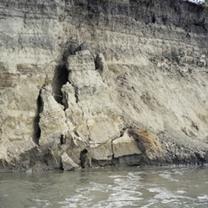
Early in the day, a crumbling bank threatens the red pirogue. They spend most of the day at the Little Missouri River and see beaver, empty Assiniboine camps, creeping juniper, and wild onions.
January 28, 1805
Ellicott's artificial horizon


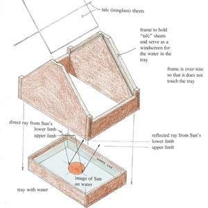
The weather is so cold at Fort Mandan among the Knife River Villages that Lewis must substitute spirituous liquor for water to make an artificial horizon for his sextant. The boats are trapped in ice.
March 6, 1803
Ellicott helps out


In Lancaster, Pennsylvania, preeminent surveyor Andrew Ellicott writes to President Jefferson accepting his request to tutor Meriwether Lewis to make accurate celestial observations during the expedition.
Notes
| ↑1 | Catharine Van Cortlandt Mathews, Andrew Ellicott: His Life and Letters (New York: Grafton Press, 1908), 164-65. |
|---|---|
| ↑2 | This page has been condensed by Nancy Davis from her article, “Andrew Ellicott: Astronomer, Mathematician, Surveyor,” We Proceeded On, Vol. 24, No. 3 (August 1998), 28-32. |
| ↑3 | On the subject of coded letters, see Jefferson-Lewis Cryptology. |
| ↑4 | Donald Jackson, ed., Letters of the Lewis and Clark Expedition with Related Documents, 1783-1854, 2nd ed., 2 vols. (Urbana: University of Illinois Press, 1962), 1:23-25. |
| ↑5 | Ibid., 40. |
| ↑6 | For illustrated discussions of the uses of these instruments, see “Measuring the Falls.” |
| ↑7 | Jackson, Letters, 1:36-37. |
Experience the Lewis and Clark Trail
The Lewis and Clark Trail Experience—our sister site at lewisandclark.travel—connects the world to people and places on the Lewis and Clark Trail.
Discover More
- The Lewis and Clark Expedition: Day by Day by Gary E. Moulton (University of Nebraska Press, 2018). The story in prose, 14 May 1804–23 September 1806.
- The Lewis and Clark Journals: An American Epic of Discovery (abridged) by Gary E. Moulton (University of Nebraska Press, 2003). Selected journal excerpts, 14 May 1804–23 September 1806.
- The Lewis and Clark Journals. by Gary E. Moulton (University of Nebraska Press, 1983–2001). The complete story in 13 volumes.


