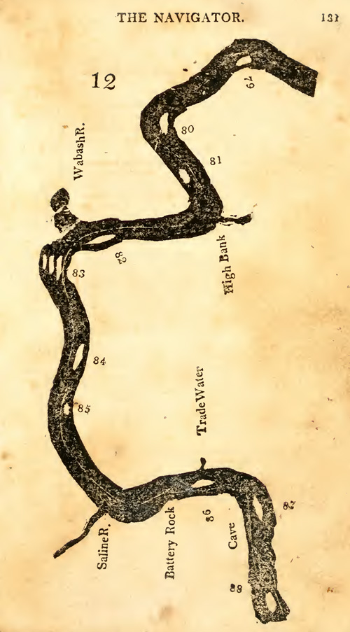
On or near this date, the expedition passes the Saline River. In 1807, Fortescue Cuming would describe the river’s mouth and a salt works about 20 miles up the river.[1]No daily record of expedition’s travel between Louisville and Fort Massac is known to exist. Locating them near Illinois’ Saline River on this date is an estimate based on information from … Continue reading
Notable locations on this map include the Wabash River, Saline River, and Cave-in-Rock opposite Cave-in-Rock Island (87), and Hurricane Island (88). The channel with the wrecked ship nearly hit by Rodney (See November 5, 1803) was likely between one of the three large islands (83) below the Wabash River.[2]Zadok Cramer, The Navigator: Containing Directions for Navigating the Monongahela, Allegheny, Ohio and Mississippi Rivers . . . (Pittsburgh: Cramer, Spear and Eichbaum, 1814), 131–136. Any edition of The Navigator available to the captains in 1803 did not include this map.
The Saline River
proceeded nine miles to Saline river on. the right. This is a fine stream, fifty yards wide, navigable for keels and batteaux. The salt-works are about twenty miles up it with the turnings of the river, though not over ten in a right line. There is a considerable hill on the right, on the lower bank of this river where it joins the Ohio.
—Fortescue Cuming (1807)[3]Fortescue Cuming, Sketches of a Tour to the Western Country: Through the States of Ohio and Kentucky, a voyage down the Ohio and Mississippi rivers, and a trip through the Mississippi territory, and … Continue reading
Experience the Lewis and Clark Trail
The Lewis and Clark Trail Experience—our sister site at lewisandclark.travel—connects the world to people and places on the Lewis and Clark Trail.
Plan a trip related to November 6, 1803:

Notes
| ↑1 | No daily record of expedition’s travel between Louisville and Fort Massac is known to exist. Locating them near Illinois’ Saline River on this date is an estimate based on information from travelers of the period and Cramer’s 1802 river guide, The Navigator. |
|---|---|
| ↑2 | Zadok Cramer, The Navigator: Containing Directions for Navigating the Monongahela, Allegheny, Ohio and Mississippi Rivers . . . (Pittsburgh: Cramer, Spear and Eichbaum, 1814), 131–136. |
| ↑3 | Fortescue Cuming, Sketches of a Tour to the Western Country: Through the States of Ohio and Kentucky, a voyage down the Ohio and Mississippi rivers, and a trip through the Mississippi territory, and part of West Florida, commenced at Philadelphia in the winter of 1807 . . . (Pittsburgh: Cramer, Spear, & Eichbaum, 1810), 246. |

