The expedition leaves the mouth of the Ohio River and turns the boats against the Mississippi current. They make ten or eleven miles and encamp on the Illinois shore within the ‘Grand Bend’.
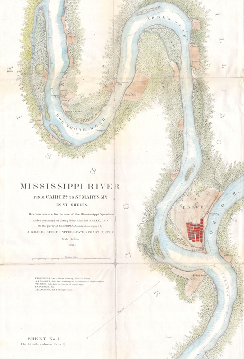
Mississippi River
from Cairo, Ill. to St. Mary’s, Mo. (1865)
Wikimedia Commons, provided by Geographicus Rare Antique Maps.
Text on map:
Mississippi River from Cairo Illinois to St. Mary’s Missouri in VI Sheets. Reconnaissance for the use of the Mississippi Squadron under the command of Acting Rear Admiral S.P.L.E.E, U.S.N. By the part of E. H. Gerdes, Assistant; assigned by A.D. Bache, Supdt. United States Coast Survey.
Turning up the Mississippi
Left our mouring on the Ohio side of the point at 10 OC. and after geting out well into the stream our course, time, and estimated distances were as follow
Course Time Estd. dist Remark or refferences h mils miles S. 70° W 1 50 3 Isld. Star. 1¼ long N. 20 W. 3 50 4½ 2 Isd. 3 m long N. 53 W 2 00 3 to point Starbd
Illinois Camp
we came too on the Starbd side and stayed all night: oposite our landing is the lower pt. of an Island on the Larbd. we came by my estimate 10½ miles today.
—Meriwether Lewis
Experience the Lewis and Clark Trail
The Lewis and Clark Trail Experience—our sister site at lewisandclark.travel—connects the world to people and places on the Lewis and Clark Trail.
Plan a trip related to November 20, 1803: