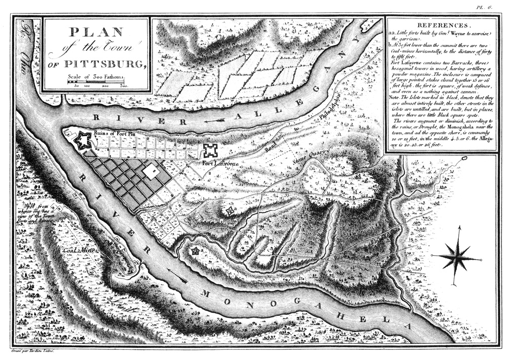
Meriwether Lewis is at Fort Fayette having a military barge built prior to departing down the Ohio River. Pittsburgh was mapped and the fort was described by French spy Victor Collot after his 1796 visit.
Pittsburgh in 1796
Plan of the Town of Pittsburgh
by Georges Henri Victor Collot (1750–1805) and Joseph Warin (unknown to 1796)
Courtesy Bibliothèque nationale de France.[1]Originally from Victor Collot, A Journey in North America, Containing a Survey of the Countries Watered by the Mississippi, Ohio, Missouri, and Other Affluing Rivers : With Exact Observations on the … Continue reading
Map Text
On the above map, Collot gives the following description:
REFERENCES.
a-a. Little forts built by Genl Wayne to exercise the garrison.
b. At 30 feet lower than the summit there are two Coal-mines horizontally, to the distance of forty to fifti feet.
Fort Lafayette contains two Barracks, three hexagonal towers in a wood, having artillery a powder magazine. the inclosure is composed of large pointed stakes closed together 15 or 16 feet high, the fort is square, of weak defence, and even as a nothing against cannon.
Fort Lafayette contains two Barracks, three hexagonal towers in wood, having artillery a powder magazine. The inclosure is composed of large pointed stakes closed together 15 or 15 feet high, the fort is square, of weak defence, and even as a nothing against cannon.
Note, the Islots marked in black, denote that they are almost intirely built, the other streets in the islots [small islands; pron. eye-lut] are untilled, and are built, but in places, where there are little black square spots.
The rivers augment or diminish, according to the rains, or Drought, the Monogahela near the town, and at the opposite shore, is commonly 10 or 12 feet, in the middle 4, 5, or 6, the Allegany is 20, 25, or 26 feet.
*This map was prepared by Collot’s French cartographer, Joseph Warin, which may account for the errors in English spelling and grammar.
Collot’s Fort Fayette
Georges Henri Victor Collot (1750–1805) was a French military officer sent to gather intelligence on the American and Spanish territories. His trip down the Ohio and Mississippi in 1796 aroused suspicion, and he was arrested separately by both the American Zebulon Pike and the Spanish Governor, Francisco Luis Héctor de Carondelet. Collot’s maps, illustrations, and written descriptions contained a wealth of information, but they were not published until 1826.
Of Fort Fayette, Collot’s opinion appears, at the least, unfavorable:
The reasons which determined Major Craig, who was the planner of this work, to build it in this spot were, that the Indians of the Six Nations, with whom the Americans were then at war, occupied a part of the Allegany river, which is situated on the right of the town, and that it was therefore necessary to place the fort on the right, and as near as possible to the town, which was punctually executed. He did not reflect, that if, by chance, the Indians should contrive to land two miles above the fort, on the left of the Allegany, and take possession of the heights, by which manoeuvre they could reach the foot of the town without being seen, they might kill the inhabitants, and burn the place, before any intelligence could reach the spot, or a cannon or musket be fired.
Fort La Fayette is merely a square with four bastions, on the platforms of which are erected-block houses or barracks. In each of these block-houses is an embrasure on the side next the country, on which are placed pieces of cannon; on that which looks towards the town a small powder magazine is built, covered only with planks. Palisades from ten to eleven feet, placed on a kind of parapet, which is only three feet in height, including the depth of the ditch already half filled up, surround this fort, and give it the form of a bullock-pen. ln a dark night four grenadiers, with a dozen faggots of dry wood, might burn the fort and all the garrison, and not a single individual escape.[2]Victor Collot, A Journey in North America, 40–41.
There is little doubt that by the time Lewis arrived in the summer of 1803, fortifications and security at Fort Fayette had improved significantly. Originally meant to be named for the famous Revolutionary War hero, the Marquis de Lafayette, Fort Fayette was built in 1792 as a response to St. Clair’s defeat—one of the worst defeats in U.S. Army in history. The garrison protected Pittsburgh from Indian attacks, supplied the western posts with ammunition, and for a time served as the headquarters of the U.S. Army.[3]Mrs. Elvert M. Davis, “Fort Fayette,” Western Pennsylvania Historical Magazine, April 1927, 10:2 accessed at https://journals.psu.edu/wph/article/view/1430/1278 on 27 April 2022.
Experience the Lewis and Clark Trail
The Lewis and Clark Trail Experience—our sister site at lewisandclark.travel—connects the world to people and places on the Lewis and Clark Trail.
Plan a trip related to August 11, 1803:

Notes
| ↑1 | Originally from Victor Collot, A Journey in North America, Containing a Survey of the Countries Watered by the Mississippi, Ohio, Missouri, and Other Affluing Rivers : With Exact Observations on the Course And Soundings of these Rivers, and on the Towns, Villages, Hamlets and Farms of that Part of the New-World, Followed by Philosophical, Political, Military and Commercial Remarks and by a Projected Line of Frontiers and General Limits, Illustrated by 36 Maps, Plans, View and Divers Cuts (Paris: Arthus Bertrand, 1826), Plate 6. |
|---|---|
| ↑2 | Victor Collot, A Journey in North America, 40–41. |
| ↑3 | Mrs. Elvert M. Davis, “Fort Fayette,” Western Pennsylvania Historical Magazine, April 1927, 10:2 accessed at https://journals.psu.edu/wph/article/view/1430/1278 on 27 April 2022. |

