Omp-he-hara-ra—Black Moccasin of Metaharta—and another Hidatsa—likely Ta-tuck-co-pin-re-ha (White Buffalo Robe Unfolded) of Mahawha visit Fort Mandan. They tell the captains how the Mandans and Awaxawi Hidatsas were decimated by wars and smallpox—the reasons they banded together into five villages.
Bands of Minnetare
by Yellowstone Public Radio[1]Originally aired weekdays by Yellowstone Public Radio during the Bicentennial observance of 2003-2006. Narrated by Hal Hansen. Scripts by Whit Hansen and Ed Jacobson. Produced by Leni Holliman. © … Continue reading
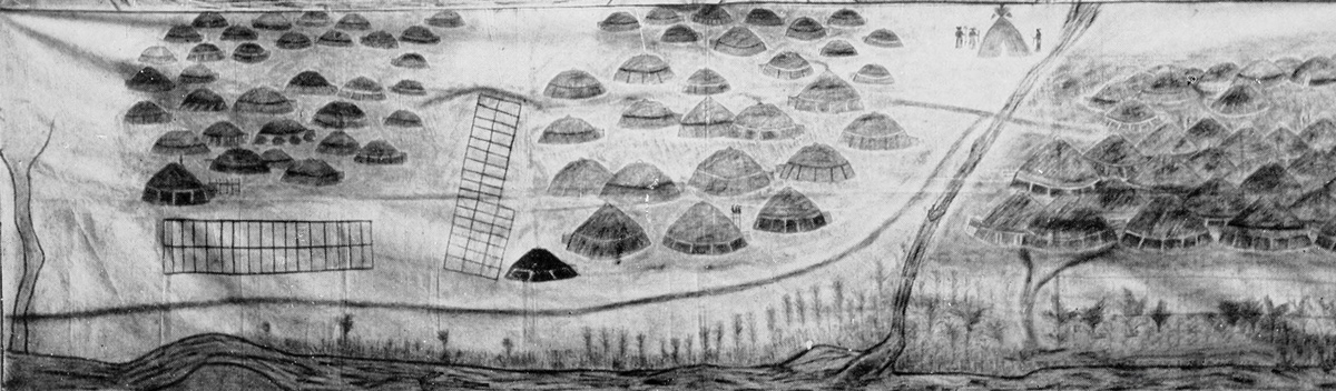
Three Hidatsa Villages
This work is considered to be in the Public Domain.
Mandan artist Sitting Rabbit shows the three Hidatsa villages at the Knife River much as they were in the winter of 1804–1805. The villages left to right are Mahawha, Metaharta—the Sakakawea Site, and Menetarra.
Awaxawi Hidatsa Migration
this Little tribe or band of Menitaraies [Hidatsas] Call themselves Ah-nah-hâ-way or people whose village is on the hill. nation formerleyed lived about 30 miles below this but beeing oppressed by the Asinniboins [Assiniboines] & Sous were Compelled to move . . . . those remaining built a village verry near to the Minitarries at the mouth of Knife R where they now live and Can raise about 50 men, they are intermixed with the Mandans & Minatariers—
—William Clark
Mandan Migration
the Mandans formerly lived in 6 [Nicholas Biddle: nine] large villages at and above the mouth of Chischeter or Heart River five [NB: six] Villages on the West Side & two [NB: three] on the East one of those Villages on the East Side of the Missouri & the larges was intirely Cut off by the Sioux & the greater part of the others and the Small Pox reduced the others.
—William Clark
Weather Diary
State of Ther. at rise
Weather wind at State of Thermt. at 4 OClock Weather at 4 Ock Wind at 4 OClock State of the River 2 [below 0] fair N W 12 [above 0] fair N W rise 3½ in.
—Meriwether Lewis[2]To assist the reader, the editor of this web page has omitted the “Day of Month 1805” column and spelled out some abbreviations.
Experience the Lewis and Clark Trail
The Lewis and Clark Trail Experience—our sister site at lewisandclark.travel—connects the world to people and places on the Lewis and Clark Trail.
Plan a trip related to March 10, 1805:


Fort Mandan is a High Potential Historic Site along the Lewis and Clark National Historic Trail managed by the U.S. National Park Service. The North Dakota Department of Parks and Recreation manages a modern reconstruction and the Lewis and Clark Interpretive Center located at US Hwy 83 and ND Hwy 200A.
Knife River Indian Villages National Historic Site is a High Potential Historic Site along the Lewis and Clark National Historic Trail managed by the U.S. National Park Service. A unit of the National Park System, the site is located at 564 County Road 37, one-half mile north of Stanton, North Dakota. It has exhibits, trails, and a visitor center.
Notes
| ↑1 | Originally aired weekdays by Yellowstone Public Radio during the Bicentennial observance of 2003-2006. Narrated by Hal Hansen. Scripts by Whit Hansen and Ed Jacobson. Produced by Leni Holliman. © 2003 by Yellowstone Public Radio. |
|---|---|
| ↑2 | To assist the reader, the editor of this web page has omitted the “Day of Month 1805” column and spelled out some abbreviations. |

